TopoQuest Logo
Do you find TopoQuest useful?
Help keep TopoQuest running and adding new maps/features by donating!
Bitcoin:  19c7KJd3qBynnjoSw5npx9KScwjBe4ifkT
Litecoin:  LXs6TkuXGGXo1vDsWCkWVdjQX94eUKd6ui
Home View Maps Find Maps Find Places Resources & Links


Quincy, Florida Topographic Map

USGS Map Title: Quincy, FL
USGS Map MRC: 30084E5
DRG (GeoTIFF) Download: o30084e5.tif


Neighboring USGS Topographic Map Quads:


  Mount Pleasant, FL  
30084F6
 

  Dogtown, FL  
30084F5
 

  Havana North, FL  
30084F4
 

  Gretna, FL  
30084E6
 

  Quincy, FL  
30084E5
 

  Havana South, FL  
30084E4
 

  Bloxham, FL  
30084D6
 

  Lake Talquin, FL  
30084D5
 

  Midway, FL  
30084D4


Map MRC Location:

N31°
W85°
N31°
W84°
H8 H7 H6 H5 H4 H3 H2 H1
G8 G7 G6 G5 G4 G3 G2 G1
F8 F7 F6 F5 F4 F3 F2 F1
E8 E7 E6 E5 E4 E3 E2 E1
D8 D7 D6 D5 D4 D3 D2 D1
C8 C7 C6 C5 C4 C3 C2 C1
B8 B7 B6 B5 B4 B3 B2 B1
A8 A7 A6 A5 A4 A3 A2 A1
N30°
W85°
N30°
W84°

Quincy, FL USGS 1:24K Topographic Map Preview:
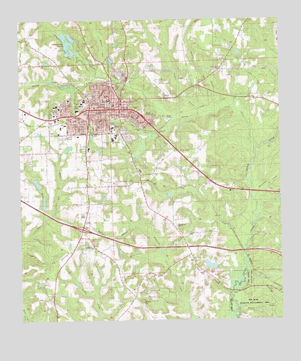
Quincy, FL USGS Topographic Map
Click on map above to begin viewing in our Map Viewer.

This topographic map contains these locations and features:
Feature Name Type Latitude Longitude GNIS ID View Map
Attapulgas (historical)Populated PlaceN30.6169°W84.5666°294508View Map
Bethlehem ChurchChurchN30.6177°W84.6230°278571View Map
Campground CemeteryCemeteryN30.5394°W84.5499°279955View Map
Cane CreekStreamN30.5030°W84.6238°279969View Map
Carter-Parramore Junior High SchoolSchoolN30.5808°W84.5802°297883View Map
City of QuincyCivilN30.5659°W84.5856°2404581View Map
Cox CreekStreamN30.5430°W84.6127°280961View Map
Eastern CemeteryCemeteryN30.5888°W84.5705°282039View Map
G CreekStreamN30.5271°W84.5177°282864View Map
Gadsden Adult Education CenterSchoolN30.5766°W84.5785°297882View Map
Gadsden Community HospitalHospitalN30.5688°W84.5488°298564View Map
Gadsden CountyCivilN30.5795°W84.6136°306918View Map
Gadsden County Emergency Medical Services Station 1 HeadquartersBuildingN30.5874°W84.5683°2661719View Map
Gadsden County Sheriff's OfficeBuildingN30.5541°W84.5909°2754470View Map
Gadsden County Sheriff's OfficeBuildingN30.5873°W84.5712°2754529View Map
Gadsden Medical CenterHospitalN30.5806°W84.5492°2094846View Map
Gadsden Memorial Hospital HeliportAirportN30.5705°W84.5496°309851View Map
Hickory Hill ChurchChurchN30.6049°W84.5288°283962View Map
Holman BranchStreamN30.5991°W84.5757°284189View Map
Hubbert BranchStreamN30.5866°W84.5366°284363View Map
Hurricane CreekStreamN30.5505°W84.5130°284425View Map
Interlocking LakesReservoirN30.6112°W84.6022°284578View Map
James A Shanks High SchoolSchoolN30.5919°W84.5938°297884View Map
Lake Talquin State ParkParkN30.5127°W84.5216°303996View Map
Little River ChurchChurchN30.5969°W84.5357°285785View Map
LittmanPopulated PlaceN30.5921°W84.5144°295410View Map
Love Street SchoolSchoolN30.5846°W84.5713°301576View Map
Monroe CreekStreamN30.5055°W84.5216°287069View Map
Mount Olive ChurchChurchN30.5074°W84.5666°287270View Map
Mount Pilgrim CemeteryCemeteryN30.5252°W84.5427°300191View Map
Mount Pilgrim ChurchChurchN30.5252°W84.5427°287284View Map
Mount Sinai ChurchChurchN30.5216°W84.6071°287317View Map
Munroe SchoolSchoolN30.5913°W84.6013°287469View Map
New Bethel ChurchChurchN30.5708°W84.5471°287599View Map
New Zion ChurchChurchN30.5260°W84.5805°287706View Map
New Zion Primitive Baptist ChurchChurchN30.5252°W84.5819°300598View Map
QuincyPopulated PlaceN30.5871°W84.5832°289404View Map
Quincy Annex Correctional InstitutionBuildingN30.5530°W84.5904°2753072View Map
Quincy CreekStreamN30.5719°W84.5113°289405View Map
Quincy Day SchoolSchoolN30.5819°W84.5977°301577View Map
Quincy DivisionCivilN30.5620°W84.6192°1935911View Map
Quincy Fire DepartmentBuildingN30.5889°W84.5817°2644084View Map
Quincy High SchoolSchoolN30.5913°W84.5827°289406View Map
Quincy Middle SchoolSchoolN30.5919°W84.5827°297885View Map
Quincy Municipal AirportAirportN30.5986°W84.5556°309850View Map
Quincy PlazaLocaleN30.5858°W84.5957°295834View Map
Quincy Police DepartmentBuildingN30.5880°W84.5748°2754530View Map
Quincy Post OfficePost OfficeN30.5754°W84.5938°2783415View Map
Robert F Munroe Day SchoolSchoolN30.5913°W84.5999°301578View Map
Robinson BranchStreamN30.5391°W84.5707°289796View Map
Saint Louis Catholic ChurchChurchN30.5752°W84.6221°300595View Map
Saint Marks ChurchChurchN30.5302°W84.5944°290290View Map
Saint Matthews ChurchChurchN30.6074°W84.5188°290318View Map
Santa ClaraPopulated PlaceN30.5838°W84.5621°290650View Map
Shiloh ChurchChurchN30.5413°W84.5935°291038View Map
Smith CemeteryCemeteryN30.5610°W84.5607°291248View Map
Stewart Street Elementary SchoolSchoolN30.5752°W84.5802°297881View Map
Tanyard BranchStreamN30.5833°W84.5499°292027View Map
Western CemeteryCemeteryN30.5924°W84.5832°293133View Map
WFHT-FM (Quincy)TowerN30.5821°W84.5996°309115View Map
WGWD-FM (Gretna)TowerN30.5569°W84.6013°309000View Map
Williams CemeteryCemeteryN30.5799°W84.5663°293323View Map
Winkley BranchStreamN30.5880°W84.5263°293412View Map
WMLO-FM (Havana)TowerN30.6224°W84.5199°309003View Map
WWSD-AM (Quincy)TowerN30.5821°W84.5996°308871View Map

Note: Coordinates in the location and feature list above are referenced to NAD83 datum.


Copyright (C) 2008-2025 Ryan Niemi / Sunset Dynamics ... All Rights Reserved