TopoQuest Logo
Do you find TopoQuest useful?
Help keep TopoQuest running and adding new maps/features by donating!
Bitcoin:  19c7KJd3qBynnjoSw5npx9KScwjBe4ifkT
Litecoin:  LXs6TkuXGGXo1vDsWCkWVdjQX94eUKd6ui
Home View Maps Find Maps Find Places Resources & Links


Rapidan, Virginia Topographic Map

USGS Map Title: Rapidan, VA
USGS Map MRC: 38078C1
DRG (GeoTIFF) Download: o38078c1.tif


Neighboring USGS Topographic Map Quads:


  Brightwood, VA  
38078D2
 

  Culpeper West, VA  
38078D1
 

  Culpeper East, VA  
38077D8
 

  Madison Mills, VA  
38078C2
 

  Rapidan, VA  
38078C1
 

  Unionville, VA  
38077C8
 

  Gordonsville, VA  
38078B2
 

  Orange, VA  
38078B1
 

  Lahore, VA  
38077B8


Map MRC Location:

N39°
W79°
N39°
W78°
H8 H7 H6 H5 H4 H3 H2 H1
G8 G7 G6 G5 G4 G3 G2 G1
F8 F7 F6 F5 F4 F3 F2 F1
E8 E7 E6 E5 E4 E3 E2 E1
D8 D7 D6 D5 D4 D3 D2 D1
C8 C7 C6 C5 C4 C3 C2 C1
B8 B7 B6 B5 B4 B3 B2 B1
A8 A7 A6 A5 A4 A3 A2 A1
N38°
W79°
N38°
W78°

Rapidan, VA USGS 1:24K Topographic Map Preview:
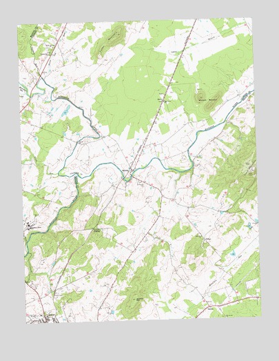
Rapidan, VA USGS Topographic Map
Click on map above to begin viewing in our Map Viewer.

This topographic map contains these locations and features:
Feature Name Type Latitude Longitude GNIS ID View Map
Arrowpoint AirportAirportN38.3057°W78.0977°2675624View Map
Aston QuarryMineN38.3433°W78.0492°2724916View Map
Beaverdam RunStreamN38.3462°W78.1208°1462971View Map
BuenaPopulated PlaceN38.3415°W78.0481°1499180View Map
Burrus DamDamN38.2768°W78.0131°1490532View Map
Burrus LakeReservoirN38.2769°W78.0136°1490533View Map
Buzzard MountainSummitN38.3421°W78.0289°1464196View Map
Cedar Grove ChurchChurchN38.3412°W78.0481°1464620View Map
Cedar MountainSummitN38.3696°W78.0714°1499230View Map
Clark MountainSummitN38.3115°W78.0025°1500064View Map
CliftonPopulated PlaceN38.2835°W78.0281°1499271View Map
Coffeewood Correctional CenterBuildingN38.3620°W78.0252°2741357View Map
Crooked RunStreamN38.3526°W78.1125°1465469View Map
Crooked Run ChurchChurchN38.3621°W78.1081°1465474View Map
District 3CivilN38.2886°W78.0349°1927230View Map
Emmanuel CemeteryCemeteryN38.3075°W78.0598°1466279View Map
Emmanuel ChurchChurchN38.3135°W78.0639°1497849View Map
Emmanuel Episcopal ChurchChurchN38.3082°W78.0625°1494743View Map
Faith Tabernacle Pentecostal Holiness ChurchChurchN38.2515°W78.1200°1496477View Map
Great RunStreamN38.3126°W78.1056°1467448View Map
Hartland-Hall Dam Number TwoDamN38.3385°W78.0997°1490378View Map
Hopewell ChurchChurchN38.2846°W78.0300°1468231View Map
Jerdone MountainSummitN38.2590°W78.0658°1468687View Map
LarmondPopulated PlaceN38.2668°W78.1206°1494748View Map
Linden DamDamN38.2785°W78.0497°1490528View Map
Linden PondReservoirN38.2759°W78.0495°1490529View Map
Mitchell QuarryMineN38.3631°W78.0486°2724891View Map
Mount Calvary CemeteryCemeteryN38.2507°W78.0192°1494751View Map
Mount Calvary ChurchChurchN38.2507°W78.0183°1470832View Map
NasonsPopulated PlaceN38.2551°W78.0267°1499789View Map
Orange Church of the NazareneChurchN38.2507°W78.1153°1496483View Map
Orange Village Shopping CenterLocaleN38.2565°W78.1147°1496486View Map
RapidanPopulated PlaceN38.3126°W78.0658°1499933View Map
Rapidan Post OfficePost OfficeN38.3140°W78.0664°2766274View Map
Rapidan Volunteer Fire and Rescue DepartmentBuildingN38.3150°W78.0669°2075457View Map
Rapidian Historic DistrictParkN38.3126°W78.0658°1497894View Map
Robinson RiverStreamN38.3112°W78.0944°1477930View Map
Saint Johns Catholic ChurchChurchN38.2507°W78.1142°1496487View Map
Trimmers CrossingPopulated PlaceN38.2890°W78.0878°1500237View Map
Upper LakeReservoirN38.3377°W78.1008°1490379View Map
Virginia Black Granite QuarryMineN38.3464°W78.0294°2724917View Map
White Oak RunStreamN38.3518°W78.1111°1476619View Map
White Oak Run ChurchChurchN38.3651°W78.1061°1476621View Map
Willis BridgeBridgeN38.3204°W78.0358°1494786View Map
WJMA-AM (Orange)TowerN38.2540°W78.1206°1502528View Map
WJMA-FM (Orange)TowerN38.2540°W78.1206°1502684View Map
Woodberry Forest Plantation (historical)LocaleN38.2912°W78.1219°1738263View Map
Woodberry Forest Post OfficePost OfficeN38.2912°W78.1218°2766509View Map
Woodberry Forest SchoolSchoolN38.2912°W78.1217°1476932View Map

Note: Coordinates in the location and feature list above are referenced to NAD83 datum.


Copyright (C) 2008-2025 Ryan Niemi / Sunset Dynamics ... All Rights Reserved