TopoQuest Logo
Do you find TopoQuest useful?
Help keep TopoQuest running and adding new maps/features by donating!
Bitcoin:  19c7KJd3qBynnjoSw5npx9KScwjBe4ifkT
Litecoin:  LXs6TkuXGGXo1vDsWCkWVdjQX94eUKd6ui
Home View Maps Find Maps Find Places Resources & Links


Ravenna, Michigan Topographic Map

USGS Map Title: Ravenna, MI
USGS Map MRC: 43085B8
DRG (GeoTIFF) Download: o43085b8.tif


Neighboring USGS Topographic Map Quads:


  Wolf Lake, MI  
43086C1
 

  Bridgeton, MI  
43085C8
 

  Grant, MI  
43085C7
 

  Sullivan, MI  
43086B1
 

  Ravenna, MI  
43085B8
 

  Casnovia, MI  
43085B7
 

  Nunica, MI  
43086A1
 

  Coopersville, MI  
43085A8
 

  Marne, MI  
43085A7


Map MRC Location:

N44°
W86°
N44°
W85°
H8 H7 H6 H5 H4 H3 H2 H1
G8 G7 G6 G5 G4 G3 G2 G1
F8 F7 F6 F5 F4 F3 F2 F1
E8 E7 E6 E5 E4 E3 E2 E1
D8 D7 D6 D5 D4 D3 D2 D1
C8 C7 C6 C5 C4 C3 C2 C1
B8 B7 B6 B5 B4 B3 B2 B1
A8 A7 A6 A5 A4 A3 A2 A1
N43°
W86°
N43°
W85°

Ravenna, MI USGS 1:24K Topographic Map Preview:
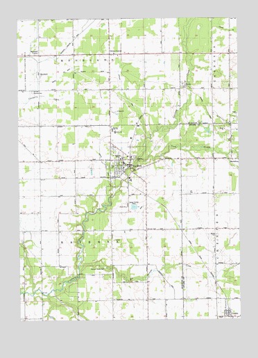
Ravenna, MI USGS Topographic Map
Click on map above to begin viewing in our Map Viewer.

This topographic map contains these locations and features:
Feature Name Type Latitude Longitude GNIS ID View Map
Beechnau Elementary SchoolSchoolN43.1900°W85.9397°2571862View Map
Bell Place CemeteryCemeteryN43.2278°W85.8794°2572006View Map
Big and Outlet DrainCanalN43.2403°W85.9698°621281View Map
Canada DrainCanalN43.2450°W85.8781°622677View Map
Champion SchoolSchoolN43.2206°W85.8800°623059View Map
Chester Township Fire DepartmentBuildingN43.1270°W85.8801°2636199View Map
ConklinPopulated PlaceN43.1289°W85.8814°623697View Map
Conklin High SchoolSchoolN43.1334°W85.8892°623699View Map
Conklin Post OfficePost OfficeN43.1272°W85.8825°2573056View Map
Conklin Reformed ChurchChurchN43.1264°W85.8825°2573057View Map
Conklin Station (historical)LocaleN43.1289°W85.8814°2573113View Map
Crickelwood Court Mobile Home ParkPopulated PlaceN43.1994°W85.8783°2571663View Map
Eastland DrainCanalN43.2208°W85.9397°2106881View Map
First Baptist Church of PaloChurchN43.1486°W85.9800°2561683View Map
First Reformed Church of RavennaChurchN43.1928°W85.9383°2571860View Map
Fisher SchoolSchoolN43.1267°W85.9870°626075View Map
Frank SchoolSchoolN43.2242°W85.9470°626404View Map
Free Methodist ChurchChurchN43.2053°W85.9472°2571857View Map
Hoogstraat SchoolSchoolN43.1622°W85.9270°628537View Map
Kellys CornersPopulated PlaceN43.2356°W85.9475°2106584View Map
Kinne DrainCanalN43.2464°W85.9448°629733View Map
Lakes Community ChurchChurchN43.2258°W85.9039°2571856View Map
McNitt CemeteryCemeteryN43.1600°W85.8881°632013View Map
McNitt SchoolSchoolN43.1636°W85.8884°632014View Map
MoorlandPopulated PlaceN43.2284°W85.9878°632663View Map
Moorland CemeteryCemeteryN43.2200°W85.9917°632664View Map
Moorland Post Office (historical)Post OfficeN43.2283°W85.9878°2571690View Map
Moorland Township Fire DepartmentBuildingN43.2356°W85.9452°2636047View Map
Morland CornerPopulated PlaceN43.2353°W85.9878°2106585View Map
Moss Ridge Golf ClubLocaleN43.2356°W85.8833°2571868View Map
North Branch Crockery CreekStreamN43.1911°W85.9309°633504View Map
Patterson ParkParkN43.1464°W85.9495°634473View Map
Porter DrainCanalN43.2236°W85.9809°635301View Map
Price SchoolSchoolN43.1914°W85.9892°635452View Map
RavennaPopulated PlaceN43.1895°W85.9370°1618856View Map
Ravenna Area Fire DepartmentBuildingN43.1847°W85.9483°2571867View Map
Ravenna Baptist ChurchChurchN43.1944°W85.9458°2571855View Map
Ravenna CemeteryCemeteryN43.1914°W85.9347°2106581View Map
Ravenna Creek Golf CourseLocaleN43.2000°W85.9528°2571869View Map
Ravenna Family PracticeHospitalN43.1847°W85.9425°2571865View Map
Ravenna High SchoolSchoolN43.2036°W85.9464°2106583View Map
Ravenna Middle SchoolSchoolN43.2028°W85.9450°2571870View Map
Ravenna Post OfficePost OfficeN43.1844°W85.9425°2571864View Map
Ravenna Station (historical)LocaleN43.1842°W85.9458°2571861View Map
Ravenna Township Public LibraryBuildingN43.1892°W85.9428°2571866View Map
Ravenna United Methodist ChurchChurchN43.1894°W85.9397°2571859View Map
Rio Grande CreekStreamN43.1456°W85.9662°635945View Map
Saint Catherine's CemeteryCemeteryN43.1928°W85.9411°2106582View Map
Saint Catherine's ChurchChurchN43.1917°W85.9419°2571858View Map
Saint Catherine's SchoolSchoolN43.1903°W85.9403°2571863View Map
Six Corners Post Office (historical)Post OfficeN43.1336°W85.9069°2572854View Map
SlocumPopulated PlaceN43.2222°W85.9098°1623192View Map
Slocum Post Office (historical)Post OfficeN43.2222°W85.9097°2571687View Map
Tidioute DrainCanalN43.1914°W85.9517°1614852View Map
Township of MoorlandCivilN43.2495°W85.9679°1626765View Map
Township of RavennaCivilN43.1622°W85.9677°1626954View Map
Village of RavennaCivilN43.1889°W85.9415°2399046View Map
Wayside ChapelChurchN43.1625°W85.9275°2106580View Map
Zoll SchoolSchoolN43.1625°W85.9781°1616965View Map

Note: Coordinates in the location and feature list above are referenced to NAD83 datum.


Copyright (C) 2008-2024 Ryan Niemi / Sunset Dynamics ... All Rights Reserved