TopoQuest Logo
Do you find TopoQuest useful?
Help keep TopoQuest running and adding new maps/features by donating!
Bitcoin:  19c7KJd3qBynnjoSw5npx9KScwjBe4ifkT
Litecoin:  LXs6TkuXGGXo1vDsWCkWVdjQX94eUKd6ui
Home View Maps Find Maps Find Places Resources & Links


Red Rock, Oklahoma Topographic Map

USGS Map Title: Red Rock, OK
USGS Map MRC: 36097D2
DRG (GeoTIFF) Download: o36097d2.tif


Neighboring USGS Topographic Map Quads:


  Tonkawa SE, OK  
36097E3
 

  Marland, OK  
36097E2
 

  Ponca City SE, OK  
36097E1
 

  Ceres, OK  
36097D3
 

  Red Rock, OK  
36097D2
 

  Morrison NE, OK  
36097D1
 

  Perry, OK  
36097C3
 

  Black Bear, OK  
36097C2
 

  Morrison, OK  
36097C1


Map MRC Location:

N37°
W98°
N37°
W97°
H8 H7 H6 H5 H4 H3 H2 H1
G8 G7 G6 G5 G4 G3 G2 G1
F8 F7 F6 F5 F4 F3 F2 F1
E8 E7 E6 E5 E4 E3 E2 E1
D8 D7 D6 D5 D4 D3 D2 D1
C8 C7 C6 C5 C4 C3 C2 C1
B8 B7 B6 B5 B4 B3 B2 B1
A8 A7 A6 A5 A4 A3 A2 A1
N36°
W98°
N36°
W97°

Red Rock, OK USGS 1:24K Topographic Map Preview:
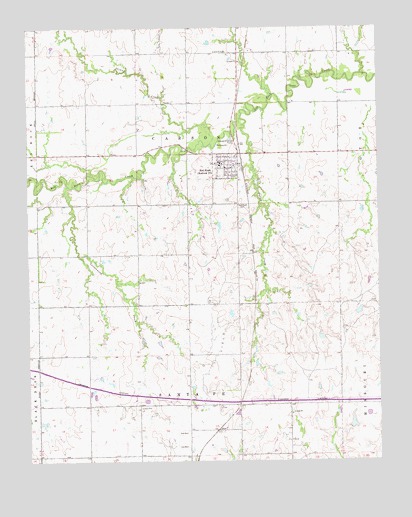
Red Rock, OK USGS Topographic Map
Click on map above to begin viewing in our Map Viewer.

This topographic map contains these locations and features:
Feature Name Type Latitude Longitude GNIS ID View Map
Cottonwood CreekStreamN36.4545°W97.2359°1091714View Map
Frontier Elementary SchoolSchoolN36.4617°W97.1587°1790768View Map
Frontier High SchoolSchoolN36.4624°W97.1592°1790446View Map
Legend CreekStreamN36.4737°W97.1739°1098470View Map
Lower Red Rock Creek Site 18 DamDamN36.4167°W97.2237°1752219View Map
Lower Red Rock Creek Site 18 ReservoirReservoirN36.4156°W97.2230°1752220View Map
Lower Red Rock Creek Site 21 DamDamN36.4484°W97.1887°1752221View Map
Lower Red Rock Creek Site 21 ReservoirReservoirN36.4461°W97.1889°1752222View Map
Lower Red Rock Creek Site 23 DamDamN36.4600°W97.1353°1752223View Map
Lower Red Rock Creek Site 23 ReservoirReservoirN36.4595°W97.1364°1752224View Map
Noble CountyCivilN36.3886°W97.2305°1101839View Map
Oknoname 103006 DamDamN36.4434°W97.1820°1753511View Map
Oknoname 103006 ReservoirReservoirN36.4429°W97.1821°1753512View Map
OtoePopulated PlaceN36.3839°W97.1834°1100711View Map
Red RockPopulated PlaceN36.4592°W97.1789°1097121View Map
Red Rock CemeteryCemeteryN36.4485°W97.1743°1097123View Map
Red Rock Rural Fire AssociationBuildingN36.4613°W97.1817°2658268View Map
Redrock Post OfficePost OfficeN36.4592°W97.1789°1721362View Map
Skinny CreekStreamN36.4664°W97.1856°1098097View Map
Town of Red RockCivilN36.4601°W97.1796°2412538View Map
Township of CarsonCivilN36.4667°W97.1920°1824794View Map
Township of Santa FeCivilN36.3778°W97.1920°1824797View Map

Note: Coordinates in the location and feature list above are referenced to NAD83 datum.


Copyright (C) 2008-2025 Ryan Niemi / Sunset Dynamics ... All Rights Reserved