TopoQuest Logo
Do you find TopoQuest useful?
Help keep TopoQuest running and adding new maps/features by donating!
Bitcoin:  19c7KJd3qBynnjoSw5npx9KScwjBe4ifkT
Litecoin:  LXs6TkuXGGXo1vDsWCkWVdjQX94eUKd6ui
Home View Maps Find Maps Find Places Resources & Links


Red Wing, Colorado Topographic Map

USGS Map Title: Red Wing, CO
USGS Map MRC: 37105F3
DRG (GeoTIFF) Download: o37105f3.tif


Neighboring USGS Topographic Map Quads:


  Medano Pass, CO  
37105G4
 

  Creager Reservoir, CO  
37105G3
 

  Gardner, CO  
37105G2
 

  Mosca Pass, CO  
37105F4
 

  Red Wing, CO  
37105F3
 

  Little Sheep Mountain, CO  
37105F2
 

  Blanca Peak, CO  
37105E4
 

  Russell, CO  
37105E3
 

  La Veta Pass, CO  
37105E2


Map MRC Location:

N38°
W106°
N38°
W105°
H8 H7 H6 H5 H4 H3 H2 H1
G8 G7 G6 G5 G4 G3 G2 G1
F8 F7 F6 F5 F4 F3 F2 F1
E8 E7 E6 E5 E4 E3 E2 E1
D8 D7 D6 D5 D4 D3 D2 D1
C8 C7 C6 C5 C4 C3 C2 C1
B8 B7 B6 B5 B4 B3 B2 B1
A8 A7 A6 A5 A4 A3 A2 A1
N37°
W106°
N37°
W105°

Red Wing, CO USGS 1:24K Topographic Map Preview:
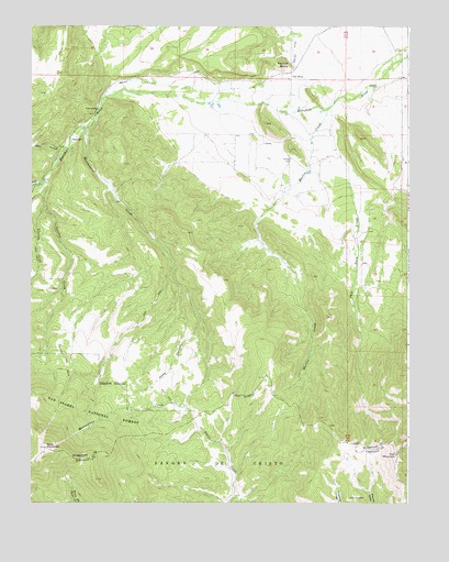
Red Wing, CO USGS Topographic Map
Click on map above to begin viewing in our Map Viewer.

This topographic map contains these locations and features:
Feature Name Type Latitude Longitude GNIS ID View Map
Cascade TrailTrailN37.6531°W105.3700°203609View Map
ChamaPopulated PlaceN37.7189°W105.2989°192667View Map
Chama CemeteryCemeteryN37.7149°W105.2891°192671View Map
Copper King MineMineN37.6275°W105.2600°1735741View Map
Deep CanyonValleyN37.6748°W105.3202°192675View Map
Deus Pioneer DitchCanalN37.7260°W105.2834°2711863View Map
Gonzales CemeteryCemeteryN37.7342°W105.2600°192670View Map
Iron MountainSummitN37.6375°W105.2539°192679View Map
Manzanares CreekStreamN37.7256°W105.3547°192665View Map
Manzanares Ditch Number 1CanalN37.7316°W105.3079°2723498View Map
Manzanares Ditch Number 2CanalN37.7307°W105.3124°2723499View Map
Martin CreekStreamN37.7286°W105.2767°192672View Map
May CreekStreamN37.7178°W105.3636°192645View Map
McIntire DamDamN37.7133°W105.2572°201236View Map
McIntire MineMineN37.6858°W105.2614°1735096View Map
McIntire ReservoirReservoirN37.7133°W105.2572°201237View Map
Montez DitchCanalN37.7342°W105.3019°203601View Map
Pala Dura DamDamN37.6883°W105.2639°201244View Map
Pala Dura ReservoirReservoirN37.6874°W105.2640°201245View Map
Palo Duro CreekStreamN37.7292°W105.2756°192673View Map
Point of RocksSummitN37.7400°W105.2919°192668View Map
Red WingPopulated PlaceN37.7361°W105.2900°192669View Map
Santa Rosa MineMineN37.7014°W105.2592°1735097View Map
Sefton Ditch Number 2CanalN37.7288°W105.3201°2724198View Map
SharpsdaleLocaleN37.7194°W105.3617°192664View Map
Sheep CreekStreamN37.7083°W105.3717°192648View Map
Slide MountainSummitN37.6394°W105.3703°192676View Map
South Side DitchCanalN37.7371°W105.2582°2724273View Map
Stanley CreekStreamN37.7097°W105.3711°192666View Map
Stanton CreekStreamN37.7028°W105.3703°192674View Map
Upper Huerfano DitchCanalN37.7308°W105.2968°2724380View Map
Upper Huerfano Fire Protection District Redwing StationBuildingN37.7355°W105.2895°2667170View Map

Note: Coordinates in the location and feature list above are referenced to NAD83 datum.


Copyright (C) 2008-2024 Ryan Niemi / Sunset Dynamics ... All Rights Reserved