TopoQuest Logo
Do you find TopoQuest useful?
Help keep TopoQuest running and adding new maps/features by donating!
Bitcoin:  19c7KJd3qBynnjoSw5npx9KScwjBe4ifkT
Litecoin:  LXs6TkuXGGXo1vDsWCkWVdjQX94eUKd6ui
Home View Maps Find Maps Find Places Resources & Links


Republican City, Nebraska Topographic Map

USGS Map Title: Republican City, NE
USGS Map MRC: 40099A2
DRG (GeoTIFF) Download: o40099a2.tif


Neighboring USGS Topographic Map Quads:


  Huntley, NE  
40099B3
 

  Republican City NW, NE  
40099B2
 

  Republican City NE, NE  
40099B1
 

  Alma, NE  
40099A3
 

  Republican City, NE  
40099A2
 

  Bloomington, NE  
40099A1
 

  Stuttgart NE, KS  
39099H3
 

  Kensington NW, KS  
39099H2
 

  Kensington NE, KS  
39099H1


Map MRC Location:

N41°
W100°
N41°
W99°
H8 H7 H6 H5 H4 H3 H2 H1
G8 G7 G6 G5 G4 G3 G2 G1
F8 F7 F6 F5 F4 F3 F2 F1
E8 E7 E6 E5 E4 E3 E2 E1
D8 D7 D6 D5 D4 D3 D2 D1
C8 C7 C6 C5 C4 C3 C2 C1
B8 B7 B6 B5 B4 B3 B2 B1
A8 A7 A6 A5 A4 A3 A2 A1
N40°
W100°
N40°
W99°

Republican City, NE USGS 1:24K Topographic Map Preview:
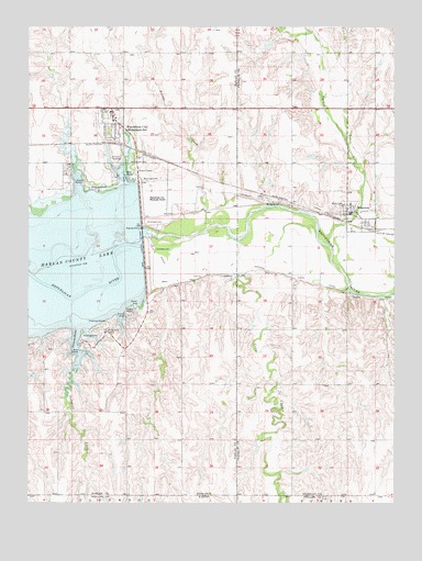
Republican City, NE USGS Topographic Map
Click on map above to begin viewing in our Map Viewer.

This topographic map contains these locations and features:
Feature Name Type Latitude Longitude GNIS ID View Map
Cedar PointCapeN40.0497°W99.2148°828011View Map
Crow CreekStreamN40.0686°W99.1786°471783View Map
Eureka CreekStreamN40.0725°W99.1893°829156View Map
Gremlin CoveBayN40.0858°W99.2179°829694View Map
Gremlin Cove CampgroundLocaleN40.0853°W99.2145°1875541View Map
Harlan County DamDamN40.0708°W99.2114°829806View Map
Harlan County DamDamN40.0696°W99.2113°1768796View Map
Hunter Cove CampgroundLocaleN40.0889°W99.2315°1875540View Map
Midland Co-op ElevatorLocaleN40.0767°W99.1415°1875411View Map
Midland Co-op ElevatorLocaleN40.0997°W99.2204°1875557View Map
NaponeeLocaleN40.0722°W99.1365°1875412View Map
NaponeePopulated PlaceN40.0767°W99.1415°831562View Map
Naponee CanalCanalN40.0561°W99.1418°831563View Map
Naponee Post OfficePost OfficeN40.0763°W99.1406°1875409View Map
Naponee Volunteer Fire DepartmentBuildingN40.0755°W99.1408°2553288View Map
North Shore MarinaLocaleN40.0833°W99.2309°1875560View Map
Outlet CampgroundLocaleN40.0742°W99.2093°1875542View Map
Patterson CreekStreamN40.0347°W99.2340°471785View Map
Patterson HarborBayN40.0433°W99.2337°831994View Map
Patterson Harbor CampgroundLocaleN40.0450°W99.2240°1875544View Map
Patterson Harbor Marina CampgroundLocaleN40.0439°W99.2309°1875543View Map
Republican CityPopulated PlaceN40.0997°W99.2204°835013View Map
Republican City Fire and Rescue DepartmentBuildingN40.0999°W99.2210°2553343View Map
Republican City Municipal Airport (historical)AirportN40.0806°W99.2095°1875554View Map
Republican City Post OfficePost OfficeN40.1028°W99.2219°1875556View Map
Republican City School (historical)SchoolN40.1006°W99.2215°1875558View Map
Republican StationLocaleN40.0942°W99.2184°835025View Map
Saathoff DamDamN40.1133°W99.1254°1767967View Map
Saint Mary Catholic ChurchChurchN40.0767°W99.1415°1875410View Map
Taylor Manor Trailer CourtPopulated PlaceN40.0997°W99.2204°1875555View Map
Township of Republican CityCivilN40.0456°W99.2356°838208View Map
Turkey CreekStreamN40.0675°W99.1476°834211View Map
United Methodist ChurchChurchN40.0995°W99.2212°1875559View Map
Village of NaponeeCivilN40.0747°W99.1386°2399436View Map
Village of Republican CityCivilN40.0987°W99.2223°2399060View Map

Note: Coordinates in the location and feature list above are referenced to NAD83 datum.


Copyright (C) 2008-2025 Ryan Niemi / Sunset Dynamics ... All Rights Reserved