TopoQuest Logo
Do you find TopoQuest useful?
Help keep TopoQuest running and adding new maps/features by donating!
Bitcoin:  19c7KJd3qBynnjoSw5npx9KScwjBe4ifkT
Litecoin:  LXs6TkuXGGXo1vDsWCkWVdjQX94eUKd6ui
Home View Maps Find Maps Find Places Resources & Links


Resseaus Crossroads, Georgia Topographic Map

USGS Map Title: Resseaus Crossroads, GA
USGS Map MRC: 33083B4
DRG (GeoTIFF) Download: o33083b4.tif


Neighboring USGS Topographic Map Quads:


  Smithboro, GA  
33083C5
 

  Eatonton, GA  
33083C4
 

  Meda, GA  
33083C3
 

  Stanfordville, GA  
33083B5
 

  Resseaus Crossroads, GA  
33083B4
 

  Lake Sinclair West, GA  
33083B3
 

  Gray, GA  
33083A5
 

  Haddock, GA  
33083A4
 

  Browns Crossing, GA  
33083A3


Map MRC Location:

N34°
W84°
N34°
W83°
H8 H7 H6 H5 H4 H3 H2 H1
G8 G7 G6 G5 G4 G3 G2 G1
F8 F7 F6 F5 F4 F3 F2 F1
E8 E7 E6 E5 E4 E3 E2 E1
D8 D7 D6 D5 D4 D3 D2 D1
C8 C7 C6 C5 C4 C3 C2 C1
B8 B7 B6 B5 B4 B3 B2 B1
A8 A7 A6 A5 A4 A3 A2 A1
N33°
W84°
N33°
W83°

Resseaus Crossroads, GA USGS 1:24K Topographic Map Preview:
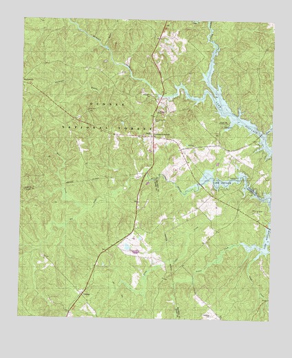
Resseaus Crossroads, GA USGS Topographic Map
Click on map above to begin viewing in our Map Viewer.

This topographic map contains these locations and features:
Feature Name Type Latitude Longitude GNIS ID View Map
Baker BranchStreamN33.2385°W83.4582°326994View Map
Bear CreekStreamN33.2029°W83.3779°327028View Map
Bethleham ChurchChurchN33.2182°W83.4368°354657View Map
Big Cedar CreekStreamN33.1804°W83.4113°354243View Map
Clopton (historical)Populated PlaceN33.2237°W83.4304°347194View Map
Cold BranchStreamN33.2182°W83.4313°347195View Map
EthridgePopulated PlaceN33.1346°W83.4682°331670View Map
Eton Church (historical)ChurchN33.2201°W83.4513°347202View Map
Freeman Grove School (historical)SchoolN33.2015°W83.4388°347206View Map
Hitchcock BranchStreamN33.2271°W83.4460°328172View Map
Humphries CemeteryCemeteryN33.1268°W83.4040°328253View Map
Key CemeteryCemeteryN33.2026°W83.4352°328393View Map
Lake Shore ChurchChurchN33.1976°W83.4135°328428View Map
Little Cedar CreekStreamN33.1768°W83.3893°328527View Map
Little River DivisionCivilN33.2356°W83.4282°1936367View Map
Lower Hawkins LakeReservoirN33.1532°W83.4418°340153View Map
Lower Hawkins Lake DamDamN33.1535°W83.4416°340152View Map
Mount Calvary ChurchChurchN33.1710°W83.3821°328868View Map
Murder CreekStreamN33.2174°W83.4046°328957View Map
Murder Creek Falls Hunt CampLocaleN33.2293°W83.4457°330652View Map
Neriah ChurchChurchN33.1710°W83.3829°345305View Map
Pierces Chapel ChurchChurchN33.2082°W83.4332°329199View Map
Pleasant Grove ChurchChurchN33.2115°W83.4666°329252View Map
Raymouth ChurchChurchN33.2115°W83.4318°329375View Map
Resseaus CrossroadsPopulated PlaceN33.2012°W83.4343°329403View Map
Rock CreekStreamN33.1707°W83.4671°329453View Map
Rock Creek Hunt CampLocaleN33.1912°W83.4941°330653View Map
Sand CreekStreamN33.1507°W83.3829°329584View Map
Sinclair Lake Recreation AreaLocaleN33.2065°W83.3985°329715View Map
Stanfordville Church (historical)ChurchN33.2199°W83.4971°347261View Map
Stiles CemeteryCemeteryN33.1571°W83.4071°345321View Map
Twin Bridges Hunt CampLocaleN33.2026°W83.3846°330651View Map
Twin Bridges TrailTrailN33.2115°W83.4077°350743View Map
Upper Hawkins LakeReservoirN33.1551°W83.4460°336162View Map
Upper Hawkins Lake DamDamN33.1535°W83.4482°336161View Map
Wiles Chapel (historical)ChurchN33.1532°W83.4566°345403View Map

Note: Coordinates in the location and feature list above are referenced to NAD83 datum.


Copyright (C) 2008-2024 Ryan Niemi / Sunset Dynamics ... All Rights Reserved