TopoQuest Logo
Do you find TopoQuest useful?
Help keep TopoQuest running and adding new maps/features by donating!
Bitcoin:  19c7KJd3qBynnjoSw5npx9KScwjBe4ifkT
Litecoin:  LXs6TkuXGGXo1vDsWCkWVdjQX94eUKd6ui
Home View Maps Find Maps Find Places Resources & Links


Reyes Peak, California Topographic Map

USGS Map Title: Reyes Peak, CA
USGS Map MRC: 34119F3
DRG (GeoTIFF) Download: o34119f3.tif


Neighboring USGS Topographic Map Quads:


  Cuyama Peak, CA  
34119G4
 

  Apache Canyon, CA  
34119G3
 

  Sawmill Mountain, CA  
34119G2
 

  Rancho Nuevo Creek, CA  
34119F4
 

  Reyes Peak, CA  
34119F3
 

  San Guillermo Mountain, CA  
34119F2
 

  Old Man Mountain, CA  
34119E4
 

  Wheeler Springs, CA  
34119E3
 

  Lion Canyon, CA  
34119E2


Map MRC Location:

N35°
W120°
N35°
W119°
H8 H7 H6 H5 H4 H3 H2 H1
G8 G7 G6 G5 G4 G3 G2 G1
F8 F7 F6 F5 F4 F3 F2 F1
E8 E7 E6 E5 E4 E3 E2 E1
D8 D7 D6 D5 D4 D3 D2 D1
C8 C7 C6 C5 C4 C3 C2 C1
B8 B7 B6 B5 B4 B3 B2 B1
A8 A7 A6 A5 A4 A3 A2 A1
N34°
W120°
N34°
W119°

Reyes Peak, CA USGS 1:24K Topographic Map Preview:
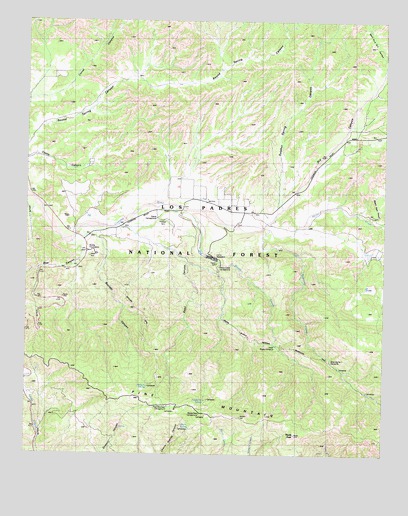
Reyes Peak, CA USGS Topographic Map
Click on map above to begin viewing in our Map Viewer.

This topographic map contains these locations and features:
Feature Name Type Latitude Longitude GNIS ID View Map
Alamo CreekStreamN34.6903°W119.2926°269461View Map
Bear CanyonValleyN34.6850°W119.3579°269724View Map
Beartrap CreekStreamN34.6903°W119.2926°269766View Map
Beartrap Number 1 CampsiteLocaleN34.6519°W119.2690°254454View Map
Beartrap Number One CampgroundLocaleN34.6508°W119.2671°275242View Map
Beartrap Number Two CampgroundLocaleN34.6422°W119.2562°275243View Map
Boulder CanyonValleyN34.6880°W119.3504°269980View Map
Camp ScheideckLocaleN34.6814°W119.3093°273601View Map
Chorro SpringSpringN34.7008°W119.3187°254457View Map
Chorro Springs CampgroundLocaleN34.6314°W119.3173°275241View Map
Dry CanyonValleyN34.6903°W119.2926°270920View Map
Los Padres National ForestForestN34.6825°W119.2576°1655276View Map
McGuire SpringSpringN34.6444°W119.3329°254459View Map
McGuire Spring Rustic CampsiteLocaleN34.6489°W119.3351°275262View Map
McGuire TrailTrailN34.6625°W119.3340°254449View Map
McGurie SpringSpringN34.6519°W119.3333°275261View Map
Ozena CampgroundLocaleN34.6930°W119.3301°254450View Map
Ozena Guard StationLocaleN34.6839°W119.3546°275253View Map
Ozena Recreation SiteLocaleN34.6950°W119.3298°275252View Map
Pine MountainRidgeN34.6342°W119.2882°272992View Map
Pine Mountain CampgroundLocaleN34.6380°W119.3268°275260View Map
Raspberry rustic CampsiteLocaleN34.6436°W119.3146°275258View Map
Raspberry SpringLocaleN34.6436°W119.3129°275259View Map
Raspberry SpringSpringN34.6432°W119.3121°254458View Map
Reyes CampgroundLocaleN34.6367°W119.3146°275240View Map
Reyes CampgroundLocaleN34.6789°W119.3076°275254View Map
Reyes CreekStreamN34.6972°W119.3262°273269View Map
Reyes Creek CampgroundLocaleN34.6792°W119.3082°254452View Map
Reyes PeakSummitN34.6308°W119.2815°273270View Map
Reyes Peak CampgroundLocaleN34.6369°W119.3146°254455View Map
Snail CanyonValleyN34.6905°W119.3432°273771View Map
Sulphur Spring CanyonValleyN34.6961°W119.2865°273951View Map
United States Forest Service Los Padres National Forest Station 72 OzenaBuildingN34.6835°W119.3540°254451View Map
Upper Reyes CampgroundLocaleN34.6569°W119.2882°275263View Map
Wagon Road CanyonValleyN34.6941°W119.2548°274362View Map
West Fork Dry CanyonValleyN34.7386°W119.2515°274430View Map

Note: Coordinates in the location and feature list above are referenced to NAD83 datum.


Copyright (C) 2008-2024 Ryan Niemi / Sunset Dynamics ... All Rights Reserved