TopoQuest Logo
Do you find TopoQuest useful?
Help keep TopoQuest running and adding new maps/features by donating!
Bitcoin:  19c7KJd3qBynnjoSw5npx9KScwjBe4ifkT
Litecoin:  LXs6TkuXGGXo1vDsWCkWVdjQX94eUKd6ui
Home View Maps Find Maps Find Places Resources & Links


Reynolds Bend, Texas Topographic Map

USGS Map Title: Reynolds Bend, TX
USGS Map MRC: 33099A3
DRG (GeoTIFF) Download: o33099a3.tif


Neighboring USGS Topographic Map Quads:


  Reynolds Bend NW, TX  
33099B4
 

  Tonk Creek, TX  
33099B3
 

  Throckmorton, TX  
33099B2
 

  Hoover Mountain, TX  
33099A4
 

  Reynolds Bend, TX  
33099A3
 

  Sibley Creek, TX  
33099A2
 

  Antelope Hills, TX  
32099H4
 

  Collins Creek, TX  
32099H3
 

  Fort Griffin, TX  
32099H2


Map MRC Location:

N34°
W100°
N34°
W99°
H8 H7 H6 H5 H4 H3 H2 H1
G8 G7 G6 G5 G4 G3 G2 G1
F8 F7 F6 F5 F4 F3 F2 F1
E8 E7 E6 E5 E4 E3 E2 E1
D8 D7 D6 D5 D4 D3 D2 D1
C8 C7 C6 C5 C4 C3 C2 C1
B8 B7 B6 B5 B4 B3 B2 B1
A8 A7 A6 A5 A4 A3 A2 A1
N33°
W100°
N33°
W99°

Reynolds Bend, TX USGS 1:24K Topographic Map Preview:
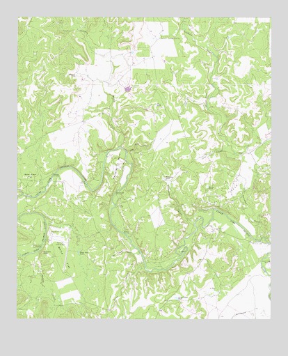
Reynolds Bend, TX USGS Topographic Map
Click on map above to begin viewing in our Map Viewer.

This topographic map contains these locations and features:
Feature Name Type Latitude Longitude GNIS ID View Map
Bake Oven FlatFlatN33.0587°W99.3709°1329940View Map
Bartholomew CrossingPopulated PlaceN33.0523°W99.3267°1377973View Map
Buzzard PeakSummitN33.0279°W99.3626°1331773View Map
Buzzard Peak CorralLocaleN33.0351°W99.3592°1378077View Map
Buzzard Peak CrossingCrossingN33.0301°W99.3634°1378076View Map
Camp Cooper RuinsLocaleN33.0448°W99.2812°1331959View Map
Camp Cooper TankReservoirN33.0089°W99.2966°1331960View Map
Clay TankReservoirN33.0889°W99.3073°1332914View Map
Gentry CrossingPopulated PlaceN33.0559°W99.3409°1378347View Map
Graveyard CanyonValleyN33.0418°W99.2854°1336872View Map
Hayford CrossingPopulated PlaceN33.0598°W99.3570°1378430View Map
Hittson BluffCliffN33.0909°W99.2817°1337848View Map
John House CanyonValleyN33.0279°W99.3148°1338762View Map
Lime Kiln CanyonValleyN33.0691°W99.3212°1339928View Map
Lime Kiln CanyonValleyN33.0709°W99.2734°1339929View Map
McKeichan CrossingPopulated PlaceN33.0151°W99.2501°1378655View Map
Paint CreekStreamN33.0518°W99.3726°1343433View Map
Paint CrossingPopulated PlaceN33.0507°W99.3709°1378818View Map
Ranger CreekStreamN33.0715°W99.3245°1375630View Map
Reynolds BendBendN33.0693°W99.3245°1345131View Map
Reynolds Bend CemeteryCemeteryN33.0640°W99.3262°1345132View Map
Reynolds CrossingPopulated PlaceN33.0357°W99.3231°1378955View Map
Rocky CreekStreamN33.0209°W99.3120°1345451View Map
Rocky TankReservoirN33.0546°W99.2812°1345496View Map
S BendBendN33.0279°W99.2940°1345793View Map
Tecumseh CreekStreamN33.0329°W99.2570°1376404View Map
Tecumseh RuinsLocaleN33.0684°W99.2640°1348325View Map
Telephone TankReservoirN33.0580°W99.3023°1348344View Map
Treadwell CemeteryCemeteryN33.0459°W99.2645°1348739View Map
Walnut CreekStreamN33.0279°W99.3654°1349433View Map
White FlatFlatN33.0254°W99.3523°1349946View Map
White Flat TankReservoirN33.0267°W99.3447°1349949View Map
Wildcat TankReservoirN33.1011°W99.3467°1350075View Map

Note: Coordinates in the location and feature list above are referenced to NAD83 datum.


Copyright (C) 2008-2025 Ryan Niemi / Sunset Dynamics ... All Rights Reserved