TopoQuest Logo
Do you find TopoQuest useful?
Help keep TopoQuest running and adding new maps/features by donating!
Bitcoin:  19c7KJd3qBynnjoSw5npx9KScwjBe4ifkT
Litecoin:  LXs6TkuXGGXo1vDsWCkWVdjQX94eUKd6ui
Home View Maps Find Maps Find Places Resources & Links


Rhems, South Carolina Topographic Map

USGS Map Title: Rhems, SC
USGS Map MRC: 33079E4
DRG (GeoTIFF) Download: o33079e4.tif


Neighboring USGS Topographic Map Quads:


  Indiantown, SC  
33079F5
 

  Henry, SC  
33079F4
 

  Outland, SC  
33079F3
 

  Warsaw, SC  
33079E5
 

  Rhems, SC  
33079E4
 

  Carvers Bay, SC  
33079E3
 

  Andrews, SC  
33079D5
 

  Olin, SC  
33079D4
 

  Georgetown North, SC  
33079D3


Map MRC Location:

N34°
W80°
N34°
W79°
H8 H7 H6 H5 H4 H3 H2 H1
G8 G7 G6 G5 G4 G3 G2 G1
F8 F7 F6 F5 F4 F3 F2 F1
E8 E7 E6 E5 E4 E3 E2 E1
D8 D7 D6 D5 D4 D3 D2 D1
C8 C7 C6 C5 C4 C3 C2 C1
B8 B7 B6 B5 B4 B3 B2 B1
A8 A7 A6 A5 A4 A3 A2 A1
N33°
W80°
N33°
W79°

Rhems, SC USGS 1:24K Topographic Map Preview:
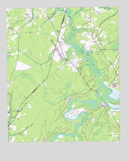
Rhems, SC USGS Topographic Map
Click on map above to begin viewing in our Map Viewer.

This topographic map contains these locations and features:
Feature Name Type Latitude Longitude GNIS ID View Map
Antioch ChurchChurchN33.5679°W79.4203°1220215View Map
Barnes School (historical)SchoolN33.5691°W79.4212°1232251View Map
Beach Swamp ChurchChurchN33.6057°W79.4956°1241371View Map
Black Mingo CemeteryCemeteryN33.6196°W79.4478°1241381View Map
Black Mingo ChurchChurchN33.6193°W79.4478°1246901View Map
Black Mingo CreekStreamN33.5532°W79.3914°1246902View Map
Black Steer SwampSwampN33.5474°W79.4448°1220777View Map
Brightman SwampStreamN33.5068°W79.4992°1220961View Map
Browns BranchStreamN33.6146°W79.4287°1221018View Map
Browns FerryLocaleN33.5466°W79.4017°1247023View Map
Browns Ferry (historical)CrossingN33.5343°W79.3881°1232515View Map
Browns Ferry BridgeBridgeN33.5468°W79.4012°1232271View Map
Browns Ferry ParkParkN33.5466°W79.4026°1232273View Map
Cedar Patch BranchStreamN33.5174°W79.4864°1221463View Map
ChoppeePopulated PlaceN33.5713°W79.3828°1221576View Map
Choppee School (historical)SchoolN33.5718°W79.3837°1232292View Map
Cold CreekStreamN33.5866°W79.4184°1221667View Map
Cow Head LandingPopulated PlaceN33.5754°W79.4089°1231200View Map
Dorsey Town SchoolSchoolN33.6191°W79.4756°1222068View Map
DorseytownPopulated PlaceN33.6166°W79.4748°1241408View Map
Easterlin PlantationLocaleN33.5285°W79.3812°1232313View Map
Francis Marion EstatesPopulated PlaceN33.5285°W79.4220°1232320View Map
Georgetown Fire Department Station 13BuildingN33.5474°W79.4034°2368272View Map
Jacks CreekStreamN33.6249°W79.4417°1223488View Map
Mill Grove CreekStreamN33.5513°W79.3889°1246667View Map
Millgrove Meeting House (historical)ChurchN33.5621°W79.3776°1232523View Map
Mingo SwampSwampN33.5707°W79.4072°1224591View Map
Mount Arat ChurchChurchN33.6027°W79.4734°1249539View Map
Mount Arat School (historical)SchoolN33.6029°W79.4728°1241466View Map
Mount Carmel ChurchChurchN33.5396°W79.4351°1224699View Map
Mount Pleasant PlantationLocaleN33.5016°W79.4573°1232406View Map
Munlin PlantationLocaleN33.5357°W79.3845°1232410View Map
Peters CreekStreamN33.6035°W79.4231°1225385View Map
Rames Farm PondReservoirN33.5794°W79.4392°1238727View Map
Red HillPopulated PlaceN33.5735°W79.4284°1231709View Map
Red Hill ChurchChurchN33.5727°W79.4323°1232439View Map
RhemsPopulated PlaceN33.5929°W79.4412°1227971View Map
Rhems PlantationLocaleN33.6021°W79.4423°1225848View Map
Roper BranchStreamN33.5288°W79.4953°1226007View Map
Rose HillPopulated PlaceN33.5996°W79.4042°1226018View Map
Rose Hill ChurchChurchN33.5927°W79.4014°1226023View Map
Saint Johns ChurchChurchN33.6060°W79.4995°1241501View Map
Saint Lukes ChurchChurchN33.6149°W79.4062°1250573View Map
Saint Lukes ParkParkN33.6160°W79.4056°1232458View Map
Saint Lukes School (historical)SchoolN33.6149°W79.4064°1232459View Map
Schoolhouse BranchStreamN33.5724°W79.4051°1250811View Map
Sleeper BranchStreamN33.5277°W79.4959°1226673View Map
Smith SwampStreamN33.5866°W79.4439°1250936View Map
South Carolina Noname 45001 D-3101 DamDamN33.5768°W79.4381°1238726View Map
Tara HallLocaleN33.5852°W79.4081°1232483View Map
Tara Hall SchoolSchoolN33.5850°W79.4090°2486465View Map
Wallace CemeteryCemeteryN33.5165°W79.4956°1227379View Map
Wee Nee PlantationLocaleN33.5341°W79.3931°1227458View Map
Weldon ChurchChurchN33.5424°W79.4773°1227468View Map
Willie TownePopulated PlaceN33.5404°W79.4331°1232506View Map
Willtown (historical)Populated PlaceN33.6182°W79.4503°1241542View Map
Wilson CemeteryCemeteryN33.5515°W79.4023°1227637View Map

Note: Coordinates in the location and feature list above are referenced to NAD83 datum.


Copyright (C) 2008-2025 Ryan Niemi / Sunset Dynamics ... All Rights Reserved