TopoQuest Logo
Do you find TopoQuest useful?
Help keep TopoQuest running and adding new maps/features by donating!
Bitcoin:  19c7KJd3qBynnjoSw5npx9KScwjBe4ifkT
Litecoin:  LXs6TkuXGGXo1vDsWCkWVdjQX94eUKd6ui
Home View Maps Find Maps Find Places Resources & Links


Richardsville, Virginia Topographic Map

USGS Map Title: Richardsville, VA
USGS Map MRC: 38077D6
DRG (GeoTIFF) Download: o38077d6.tif


Neighboring USGS Topographic Map Quads:


  Remington, VA  
38077E7
 

  Midland, VA  
38077E6
 

  Somerville, VA  
38077E5
 

  Germanna Bridge, VA  
38077D7
 

  Richardsville, VA  
38077D6
 

  Storck, VA  
38077D5
 

  Mine Run, VA  
38077C7
 

  Chancellorsville, VA  
38077C6
 

  Salem Church, VA  
38077C5


Map MRC Location:

N39°
W78°
N39°
W77°
H8 H7 H6 H5 H4 H3 H2 H1
G8 G7 G6 G5 G4 G3 G2 G1
F8 F7 F6 F5 F4 F3 F2 F1
E8 E7 E6 E5 E4 E3 E2 E1
D8 D7 D6 D5 D4 D3 D2 D1
C8 C7 C6 C5 C4 C3 C2 C1
B8 B7 B6 B5 B4 B3 B2 B1
A8 A7 A6 A5 A4 A3 A2 A1
N38°
W78°
N38°
W77°

Richardsville, VA USGS 1:24K Topographic Map Preview:
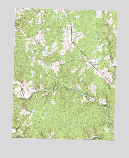
Richardsville, VA USGS Topographic Map
Click on map above to begin viewing in our Map Viewer.

This topographic map contains these locations and features:
Feature Name Type Latitude Longitude GNIS ID View Map
Alcotti RunStreamN38.4468°W77.6300°1462390View Map
Camp HappylandLocaleN38.4004°W77.7117°1464327View Map
Clevers Oak ChurchChurchN38.4718°W77.6480°1464980View Map
Deep RunStreamN38.4107°W77.6355°1465718View Map
Deerfield EstatesPopulated PlaceN38.4871°W77.7303°1749247View Map
Embrey CemeteryCemeteryN38.4561°W77.7256°1749250View Map
Embrey ChurchChurchN38.4568°W77.7267°1466276View Map
Flat RunStreamN38.3751°W77.7325°1466660View Map
Gills RunStreamN38.3756°W77.6552°2760317View Map
Golden HillsPopulated PlaceN38.4896°W77.7192°1749261View Map
GoldveinPopulated PlaceN38.4490°W77.6553°1477359View Map
Goldvein Baptist ChurchChurchN38.4473°W77.6519°1749262View Map
Goldvein Post OfficePost OfficeN38.4462°W77.6522°1749263View Map
Goldvein School (historical)SchoolN38.4768°W77.6497°1749264View Map
Goldvein Volunteer Fire and Rescue Company 8BuildingN38.4471°W77.6512°2075399View Map
Green BranchStreamN38.4673°W77.6339°1467456View Map
Grove Baptist ChurchChurchN38.4479°W77.6514°1749269View Map
Grove ChurchesChurchN38.4482°W77.6517°1467572View Map
Oakland ChurchChurchN38.4043°W77.7403°1471784View Map
Oders CornerLocaleN38.4557°W77.6622°1749304View Map
Pine BranchStreamN38.4985°W77.6425°1472329View Map
Pine ViewPopulated PlaceN38.4479°W77.6944°1499874View Map
Queens GuardPopulated PlaceN38.4691°W77.6258°2459184View Map
RichardsvillePopulated PlaceN38.4001°W77.7289°1477681View Map
Richardsville SouthPopulated PlaceN38.3899°W77.7325°1497895View Map
Richardsville United Methodist ChurchChurchN38.4010°W77.7267°1497896View Map
Richardsville Volunteer Fire and RescueBuildingN38.3946°W77.7266°2075459View Map
Rock RunStreamN38.4193°W77.6611°1473387View Map
Sherwood EstatesPopulated PlaceN38.4151°W77.6262°2459230View Map
Silver HillPopulated PlaceN38.4829°W77.6961°1477754View Map
Silver Hill Baptist ChurchChurchN38.4826°W77.6953°1749321View Map
SumerduckPopulated PlaceN38.4601°W77.7280°1477790View Map
Sumerduck Post OfficePost OfficeN38.4552°W77.7263°1749325View Map
Sumerduck RunStreamN38.4251°W77.6775°1475319View Map
Thompsons MillLocaleN38.4496°W77.6297°1749328View Map
Union ChurchChurchN38.4607°W77.7278°1476060View Map

Note: Coordinates in the location and feature list above are referenced to NAD83 datum.


Copyright (C) 2008-2025 Ryan Niemi / Sunset Dynamics ... All Rights Reserved