TopoQuest Logo
Do you find TopoQuest useful?
Help keep TopoQuest running and adding new maps/features by donating!
Bitcoin:  19c7KJd3qBynnjoSw5npx9KScwjBe4ifkT
Litecoin:  LXs6TkuXGGXo1vDsWCkWVdjQX94eUKd6ui
Home View Maps Find Maps Find Places Resources & Links


Richland, Washington Topographic Map

USGS Map Title: Richland, WA
USGS Map MRC: 46119C3
DRG (GeoTIFF) Download: o46119c3.tif


Neighboring USGS Topographic Map Quads:


  Horn Rapids Dam, WA  
46119D4
 

  Wooded Island, WA  
46119D3
 

  Mathews Corner, WA  
46119D2
 

  Benton City, WA  
46119C4
 

  Richland, WA  
46119C3
 

  Columbia Point, WA  
46119C2
 

  Webber Canyon, WA  
46119B4
 

  Badger Mountain, WA  
46119B3
 

  Kennewick, WA  
46119B2


Map MRC Location:

N47°
W120°
N47°
W119°
H8 H7 H6 H5 H4 H3 H2 H1
G8 G7 G6 G5 G4 G3 G2 G1
F8 F7 F6 F5 F4 F3 F2 F1
E8 E7 E6 E5 E4 E3 E2 E1
D8 D7 D6 D5 D4 D3 D2 D1
C8 C7 C6 C5 C4 C3 C2 C1
B8 B7 B6 B5 B4 B3 B2 B1
A8 A7 A6 A5 A4 A3 A2 A1
N46°
W120°
N46°
W119°

Richland, WA USGS 1:24K Topographic Map Preview:
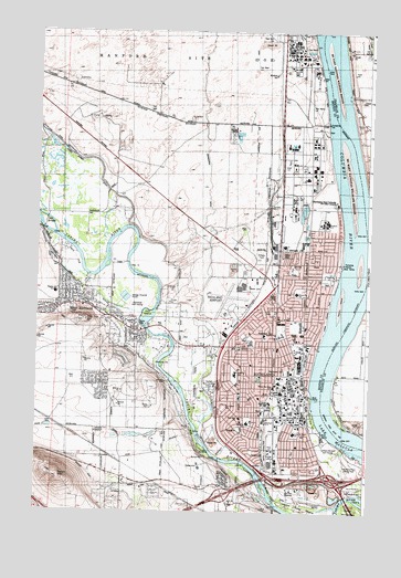
Richland, WA USGS Topographic Map
Click on map above to begin viewing in our Map Viewer.

This topographic map contains these locations and features:
Feature Name Type Latitude Longitude GNIS ID View Map
Benton County Fire Protection District 4BuildingN46.2765°W119.3461°2619364View Map
Benton County Fire Protection District 4 Station 410BuildingN46.3138°W119.3676°2619704View Map
Buckskin Golf ClubLocaleN46.2970°W119.3114°2608346View Map
Candy MountainSummitN46.2590°W119.3664°1503769View Map
Carmichael Middle SchoolSchoolN46.2740°W119.2894°1503811View Map
Chamna Natural PreserveParkN46.2501°W119.2697°1513439View Map
Chief Joseph Middle SchoolSchoolN46.2960°W119.2829°1503954View Map
Christ the King SchoolSchoolN46.2826°W119.2850°1503970View Map
City of RichlandCivilN46.2826°W119.2938°2410937View Map
Columbia Point Golf CourseLocaleN46.2613°W119.2578°2608386View Map
Columbia Point Marina ParkParkN46.2629°W119.2542°1513431View Map
Flat Top HillSummitN46.2996°W119.3561°1513366View Map
Fox IslandIslandN46.3015°W119.3328°1505013View Map
Hanford Fire Department Station 93 - Department of Energy Hanford Site Fire - Rescue - EMSBuildingN46.3683°W119.2822°2643389View Map
Hanford High SchoolSchoolN46.3254°W119.2676°1530919View Map
Horn Rapids Desert Style Golf CourseLocaleN46.3275°W119.3290°2608410View Map
Horn Rapids DitchCanalN46.3385°W119.3509°1513376View Map
Howard Amon ParkParkN46.2743°W119.2709°1513433View Map
James J Lawless ParkParkN46.2660°W119.2878°1513438View Map
Jason Lee Elementary SchoolSchoolN46.2953°W119.2944°1513377View Map
Jefferson Elementary SchoolSchoolN46.2929°W119.2730°1505799View Map
Jefferson ParkParkN46.2896°W119.2736°1513441View Map
Kadlec Regional Medical CenterHospitalN46.2812°W119.2820°1513451View Map
Ledbeder SubstationLocaleN46.2715°W119.3486°1533157View Map
Leslie Groves ParkParkN46.3004°W119.2661°1513372View Map
Lewis and Clark SchoolSchoolN46.2704°W119.2778°1506133View Map
Liberty Christian SchoolSchoolN46.2857°W119.3002°1508575View Map
Lourdes Counseling CenterHospitalN46.2831°W119.2813°2625483View Map
Marcus Whitman Elementary SchoolSchoolN46.2732°W119.2955°1509483View Map
Nelson IslandIslandN46.3043°W119.2609°1506956View Map
Paul Liddell ParkParkN46.2768°W119.3039°1513421View Map
Resthaven CemeteryCemeteryN46.2865°W119.2806°1507784View Map
RichlandPopulated PlaceN46.2857°W119.2845°1513395View Map
Richland AirportAirportN46.3056°W119.3042°1533921View Map
Richland Fire and Emergency Services Station 71BuildingN46.2805°W119.2733°2619416View Map
Richland Fire and Emergency Services Station 72BuildingN46.3006°W119.2809°2619551View Map
Richland High SchoolSchoolN46.2782°W119.2889°1530843View Map
Richland Police DepartmentBuildingN46.2784°W119.2746°2768896View Map
Richland Post OfficePost OfficeN46.2739°W119.2775°2769209View Map
Riverview Natural PreserveParkN46.2554°W119.2567°1513440View Map
Sacajawea SchoolSchoolN46.3068°W119.2772°1513397View Map
Sham-na-pum Golf CourseLocaleN46.2665°W119.2664°1533021View Map
Sunset Memorial GardensCemeteryN46.2829°W119.3075°1508842View Map
Twin BridgesBridgeN46.3249°W119.3722°1509141View Map
W E Johnson ParkParkN46.2801°W119.3134°1513442View Map
West RichlandPopulated PlaceN46.3043°W119.3614°1512794View Map
West Richland Municipal Golf CourseLocaleN46.3015°W119.3384°1513396View Map
West Richland Police DepartmentBuildingN46.2966°W119.3373°2721918View Map
West Richland Post OfficePost OfficeN46.3009°W119.3518°2781610View Map
West Side ChurchChurchN46.2746°W119.2984°1513452View Map
Westgate Shopping CenterLocaleN46.2926°W119.2986°1513790View Map
Westwood ParkParkN46.2974°W119.2917°1509439View Map

Note: Coordinates in the location and feature list above are referenced to NAD83 datum.


Copyright (C) 2008-2024 Ryan Niemi / Sunset Dynamics ... All Rights Reserved