TopoQuest Logo
Do you find TopoQuest useful?
Help keep TopoQuest running and adding new maps/features by donating!
Bitcoin:  19c7KJd3qBynnjoSw5npx9KScwjBe4ifkT
Litecoin:  LXs6TkuXGGXo1vDsWCkWVdjQX94eUKd6ui
Home View Maps Find Maps Find Places Resources & Links


Richtex, South Carolina Topographic Map

USGS Map Title: Richtex, SC
USGS Map MRC: 34081B2
DRG (GeoTIFF) Download: o34081b2.tif


Neighboring USGS Topographic Map Quads:


  Jenkinsville, SC  
34081C3
 

  Rion, SC  
34081C2
 

  Winnsboro Mills, SC  
34081C1
 

  Chapin, SC  
34081B3
 

  Richtex, SC  
34081B2
 

  Irmo NE, SC  
34081B1
 

  Lake Murray East, SC  
34081A3
 

  Irmo, SC  
34081A2
 

  Columbia North, SC  
34081A1


Map MRC Location:

N35°
W82°
N35°
W81°
H8 H7 H6 H5 H4 H3 H2 H1
G8 G7 G6 G5 G4 G3 G2 G1
F8 F7 F6 F5 F4 F3 F2 F1
E8 E7 E6 E5 E4 E3 E2 E1
D8 D7 D6 D5 D4 D3 D2 D1
C8 C7 C6 C5 C4 C3 C2 C1
B8 B7 B6 B5 B4 B3 B2 B1
A8 A7 A6 A5 A4 A3 A2 A1
N34°
W82°
N34°
W81°

Richtex, SC USGS 1:24K Topographic Map Preview:
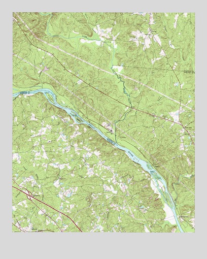
Richtex, SC USGS Topographic Map
Click on map above to begin viewing in our Map Viewer.

This topographic map contains these locations and features:
Feature Name Type Latitude Longitude GNIS ID View Map
Ashley BridgeBridgeN34.1960°W81.1684°1245676View Map
Ballentine Post OfficePost OfficeN34.1308°W81.2492°1248915View Map
Big Cedar CreekStreamN34.1390°W81.1384°1227858View Map
BookmanPopulated PlaceN34.1629°W81.1531°1227869View Map
Bookman CreekStreamN34.1490°W81.1776°1220891View Map
Bookman IslandIslandN34.1460°W81.1451°1245689View Map
Bookman ShoalsBarN34.1588°W81.1534°1220892View Map
Boone CreekStreamN34.2035°W81.2409°1220893View Map
Boyd BranchStreamN34.1518°W81.2295°1220914View Map
Browns BridgeBridgeN34.2329°W81.1868°1221019View Map
Calla (historical)Populated PlaceN34.1271°W81.1765°1248979View Map
Cedar CreekPopulated PlaceN34.1846°W81.1318°1227880View Map
Cedar Creek CemeteryCemeteryN34.1801°W81.1276°1248991View Map
Cedar Creek ChurchChurchN34.1804°W81.1273°1249461View Map
Cedar Creek School (historical)SchoolN34.1874°W81.1379°1248993View Map
Chapel ShoalsBarN34.1924°W81.2076°1245700View Map
Columbia - Richland Fire Station Dutch Fork BallentineBuildingN34.1255°W81.2164°2578366View Map
County Grove ChurchChurchN34.2360°W81.1656°1247402View Map
Crooked Run ChurchChurchN34.2368°W81.1551°1247428View Map
Dutch Fork DivisionCivilN34.1370°W81.2114°1938251View Map
Freshley BranchStreamN34.2068°W81.2293°1222562View Map
Freshley ShoalsBarN34.2051°W81.2268°1247834View Map
Gibson BranchStreamN34.2343°W81.1895°1222694View Map
Gibson CemeteryCemeteryN34.2454°W81.2051°1222695View Map
Haltiwanger IslandIslandN34.2018°W81.2234°1245885View Map
Hawkins Pond D-1569 DamDamN34.2168°W81.2298°1239010View Map
Hickory IslandIslandN34.1568°W81.1504°1223144View Map
Hollinshead CreekStreamN34.1529°W81.1512°1249502View Map
Home BranchStreamN34.1899°W81.1729°1249504View Map
Hope CreekStreamN34.1488°W81.1801°1223276View Map
Huffman IslandIslandN34.1893°W81.2040°1246093View Map
Interchange 97CrossingN34.1460°W81.2462°1228196View Map
JenningsPopulated PlaceN34.2404°W81.1554°1223542View Map
Leitner Grove School (historical)SchoolN34.2363°W81.1651°1237037View Map
Lindler CemeteryCemeteryN34.1274°W81.2181°1249200View Map
Line School (historical)SchoolN34.1307°W81.2279°1249201View Map
Little RiverStreamN34.1757°W81.1781°1229931View Map
LittletonPopulated PlaceN34.1790°W81.1756°1231494View Map
Mann CemeteryCemeteryN34.2349°W81.1759°1224293View Map
Manns BranchStreamN34.2371°W81.1918°1246523View Map
Meetze PondReservoirN34.1758°W81.2087°1237623View Map
Metz BranchStreamN34.1513°W81.2298°1224461View Map
MontgomeryPopulated PlaceN34.1338°W81.1343°1227949View Map
Mussel CreekStreamN34.1868°W81.2054°1224906View Map
Nicholas School (historical)SchoolN34.1335°W81.1470°1249249View Map
Piedmont School (historical)SchoolN34.1271°W81.2179°1249273View Map
RichtexPopulated PlaceN34.1835°W81.1818°1250376View Map
Robinson CemeteryCemeteryN34.2426°W81.1609°1225917View Map
Saint Johns ChurchChurchN34.1665°W81.2009°1226157View Map
Saint Johns School (historical)SchoolN34.1671°W81.2006°1249324View Map
Saint Pauls CemeteryCemeteryN34.1272°W81.1755°1226239View Map
Shady Grove ChurchChurchN34.1557°W81.2176°1226516View Map
Shavers CreekStreamN34.2021°W81.1698°1249351View Map
Shiloh Church (historical)ChurchN34.2082°W81.1970°1237087View Map
Shiloh School (historical)SchoolN34.2085°W81.1973°1237090View Map
South Carolina Noname 24007 D-1263 DamDamN34.2035°W81.1798°1239037View Map
Van CemeteryCemeteryN34.2388°W81.1626°1227332View Map
Wallaceville School (historical)SchoolN34.2332°W81.2373°1237101View Map
Wateree CreekStreamN34.2024°W81.2470°1227423View Map
Wayside School (historical)SchoolN34.1863°W81.1304°1249410View Map
Wetze Pond D-0540 DamDamN34.1751°W81.2082°1237622View Map
Wildhorse BranchStreamN34.1504°W81.2307°1227598View Map
Zion Pilgrim ChurchChurchN34.1910°W81.1520°1227767View Map

Note: Coordinates in the location and feature list above are referenced to NAD83 datum.


Copyright (C) 2008-2025 Ryan Niemi / Sunset Dynamics ... All Rights Reserved