TopoQuest Logo
Do you find TopoQuest useful?
Help keep TopoQuest running and adding new maps/features by donating!
Bitcoin:  19c7KJd3qBynnjoSw5npx9KScwjBe4ifkT
Litecoin:  LXs6TkuXGGXo1vDsWCkWVdjQX94eUKd6ui
Home View Maps Find Maps Find Places Resources & Links


Riley Canyon, Colorado Topographic Map

USGS Map Title: Riley Canyon, CO
USGS Map MRC: 37103F5
DRG (GeoTIFF) Download: o37103f5.tif


Neighboring USGS Topographic Map Quads:


  La Junta SW, CO  
37103G6
 

  La Junta SE, CO  
37103G5
 

  Higbee, CO  
37103G4
 

  Packers Gap, CO  
37103F6
 

  Riley Canyon, CO  
37103F5
 

  Corbin Canyon, CO  
37103F4
 

  O V Mesa, CO  
37103E6
 

  Beaty Canyon, CO  
37103E5
 

  Lost Canyon, CO  
37103E4


Map MRC Location:

N38°
W104°
N38°
W103°
H8 H7 H6 H5 H4 H3 H2 H1
G8 G7 G6 G5 G4 G3 G2 G1
F8 F7 F6 F5 F4 F3 F2 F1
E8 E7 E6 E5 E4 E3 E2 E1
D8 D7 D6 D5 D4 D3 D2 D1
C8 C7 C6 C5 C4 C3 C2 C1
B8 B7 B6 B5 B4 B3 B2 B1
A8 A7 A6 A5 A4 A3 A2 A1
N37°
W104°
N37°
W103°

Riley Canyon, CO USGS 1:24K Topographic Map Preview:
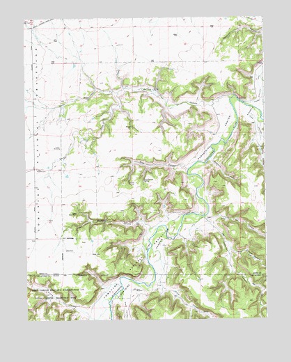
Riley Canyon, CO USGS Topographic Map
Click on map above to begin viewing in our Map Viewer.

This topographic map contains these locations and features:
Feature Name Type Latitude Longitude GNIS ID View Map
Anderson CanyonValleyN37.6676°W103.5326°195845View Map
Antone SpringSpringN37.6814°W103.5711°195838View Map
Clark CanyonValleyN37.6335°W103.5761°195848View Map
Comanche National GrasslandForestN37.6548°W103.5648°203883View Map
Girard WindmillLocaleN37.6961°W103.6072°195834View Map
Good Pasture SpringSpringN37.6828°W103.5633°195839View Map
Horse CanyonValleyN37.7004°W103.5021°195843View Map
Jack CanyonValleyN37.7162°W103.5177°195831View Map
Last Chance CanyonValleyN37.6539°W103.5185°195850View Map
Little WindmillLocaleN37.6875°W103.6194°195835View Map
Martinez CemeteryCemeteryN37.7303°W103.5008°195833View Map
Miller CanyonValleyN37.6384°W103.5544°195849View Map
Minnie CanyonValleyN37.6268°W103.5924°195829View Map
North Fork Jack CanyonValleyN37.7192°W103.5765°195830View Map
Penitenta CanyonValleyN37.6917°W103.5283°195841View Map
Penitenta ChurchChurchN37.6997°W103.5233°195840View Map
Purgatoire CanyonValleyN37.7160°W103.5178°195851View Map
Riley CanyonValleyN37.6870°W103.5403°195837View Map
River WindmillLocaleN37.6372°W103.5683°195847View Map
Rock WaterholeSpringN37.6689°W103.5988°195836View Map
San Jose CemeteryCemeteryN37.7194°W103.5075°2485951View Map
South Fork Jack CanyonValleyN37.7192°W103.5766°195827View Map
Terrel CanyonValleyN37.6680°W103.5309°195844View Map
Vose CanyonValleyN37.7077°W103.5019°195842View Map
Withers CanyonValleyN37.6629°W103.5602°195846View Map

Note: Coordinates in the location and feature list above are referenced to NAD83 datum.


Copyright (C) 2008-2025 Ryan Niemi / Sunset Dynamics ... All Rights Reserved