TopoQuest Logo
Do you find TopoQuest useful?
Help keep TopoQuest running and adding new maps/features by donating!
Bitcoin:  19c7KJd3qBynnjoSw5npx9KScwjBe4ifkT
Litecoin:  LXs6TkuXGGXo1vDsWCkWVdjQX94eUKd6ui
Home View Maps Find Maps Find Places Resources & Links


Big Pine Mountain, California Topographic Map

USGS Map Title: Big Pine Mountain, CA
USGS Map MRC: 34119F6
DRG (GeoTIFF) Download: o34119f6.tif


Neighboring USGS Topographic Map Quads:


  Hurricane Deck, CA  
34119G7
 

  Salisbury Potrero, CA  
34119G6
 

  Fox Mountain, CA  
34119G5
 

  San Rafael Mountain, CA  
34119F7
 

  Big Pine Mountain, CA  
34119F6
 

  Madulce Peak, CA  
34119F5
 

  San Marcos Pass, CA  
34119E7
 

  Little Pine Mountain, CA  
34119E6
 

  Hildreth Peak, CA  
34119E5


Map MRC Location:

N35°
W120°
N35°
W119°
H8 H7 H6 H5 H4 H3 H2 H1
G8 G7 G6 G5 G4 G3 G2 G1
F8 F7 F6 F5 F4 F3 F2 F1
E8 E7 E6 E5 E4 E3 E2 E1
D8 D7 D6 D5 D4 D3 D2 D1
C8 C7 C6 C5 C4 C3 C2 C1
B8 B7 B6 B5 B4 B3 B2 B1
A8 A7 A6 A5 A4 A3 A2 A1
N34°
W120°
N34°
W119°

Big Pine Mountain, CA USGS 1:24K Topographic Map Preview:
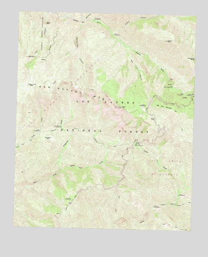
Big Pine Mountain, CA USGS Topographic Map
Click on map above to begin viewing in our Map Viewer.

This topographic map contains these locations and features:
Feature Name Type Latitude Longitude GNIS ID View Map
Alamar Guard StationLocaleN34.7039°W119.6271°269455View Map
Bear CampgroundLocaleN34.7042°W119.6337°269718View Map
Big Pine CampgroundLocaleN34.6972°W119.6601°269835View Map
Big Pine CanyonValleyN34.7303°W119.6746°269836View Map
Big Pine MountainSummitN34.6969°W119.6543°1660333View Map
Bluff Camp Forest Service FaciltiyLocaleN34.6725°W119.6674°275393View Map
Bluff CampgroundLocaleN34.6739°W119.6665°269941View Map
Chokecherry SpringSpringN34.7248°W119.6265°270443View Map
Coche CampgroundLocaleN34.6811°W119.7340°270520View Map
Cottonwood CampgroundLocaleN34.7455°W119.6974°270618View Map
Fall CanyonValleyN34.7492°W119.7329°271094View Map
Grapevine CreekStreamN34.6592°W119.7190°271404View Map
Grapevine TrailTrailN34.6739°W119.6885°271408View Map
Heath CampgroundLocaleN34.7375°W119.6835°271530View Map
Jackrabbit FlatFlatN34.6769°W119.7282°271752View Map
Judell CanyonValleyN34.7389°W119.6849°271835View Map
Logan CanyonValleyN34.7458°W119.7029°272159View Map
Lower Bear CampgroundLocaleN34.7083°W119.6412°272251View Map
Lower Grapevine CampgroundLocaleN34.6839°W119.7187°272257View Map
Mansfield CampgroundLocaleN34.7467°W119.7140°275391View Map
Mission Pine BasinBasinN34.7069°W119.7407°272503View Map
Mission Pine Basin CampgroundLocaleN34.7105°W119.7465°275390View Map
Mission Pine TrailTrailN34.7067°W119.7068°272504View Map
Narrows CampgroundLocaleN34.6386°W119.6524°272623View Map
Pelch Cabin (historical)BuildingN34.6780°W119.7115°1693284View Map
Pelch CampLocaleN34.6800°W119.7129°275394View Map
Pens CampgroundLocaleN34.6405°W119.6368°275392View Map
Poplar CampgroundLocaleN34.6453°W119.6354°273077View Map
Rattlesnake CanyonValleyN34.7455°W119.7060°247990View Map
Samon PeakSummitN34.7344°W119.6457°273430View Map
Sisquoc Condor SanctuaryParkN34.7394°W119.7343°273725View Map
Sisquoc FallsFallsN34.7425°W119.7312°273727View Map
The Pines CampgroundLocaleN34.6419°W119.7112°250400View Map
Upper Grapevine CampgroundLocaleN34.6905°W119.7115°275389View Map

Note: Coordinates in the location and feature list above are referenced to NAD83 datum.


Copyright (C) 2008-2025 Ryan Niemi / Sunset Dynamics ... All Rights Reserved