TopoQuest Logo
Do you find TopoQuest useful?
Help keep TopoQuest running and adding new maps/features by donating!
Bitcoin:  19c7KJd3qBynnjoSw5npx9KScwjBe4ifkT
Litecoin:  LXs6TkuXGGXo1vDsWCkWVdjQX94eUKd6ui
Home View Maps Find Maps Find Places Resources & Links


Ringgold, Virginia Topographic Map

USGS Map Title: Ringgold, VA
USGS Map MRC: 36079E3
DRG (GeoTIFF) Download: o36079e3.tif


Neighboring USGS Topographic Map Quads:


  Mount Hermon, VA  
36079F4
 

  Blairs, VA  
36079F3
 

  Ingram, VA  
36079F2
 

  Danville, VA  
36079E4
 

  Ringgold, VA  
36079E3
 

  Milton, NC  
36079E2
 

  Park Spring, NC  
36079D4
 

  Yanceyville, NC  
36079D3
 

  Leasburg, NC  
36079D2


Map MRC Location:

N37°
W80°
N37°
W79°
H8 H7 H6 H5 H4 H3 H2 H1
G8 G7 G6 G5 G4 G3 G2 G1
F8 F7 F6 F5 F4 F3 F2 F1
E8 E7 E6 E5 E4 E3 E2 E1
D8 D7 D6 D5 D4 D3 D2 D1
C8 C7 C6 C5 C4 C3 C2 C1
B8 B7 B6 B5 B4 B3 B2 B1
A8 A7 A6 A5 A4 A3 A2 A1
N36°
W80°
N36°
W79°

Ringgold, VA USGS 1:24K Topographic Map Preview:
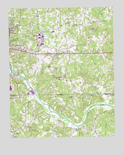
Ringgold, VA USGS Topographic Map
Click on map above to begin viewing in our Map Viewer.

This topographic map contains these locations and features:
Feature Name Type Latitude Longitude GNIS ID View Map
Barkers BranchStreamN36.5699°W79.3717°1462790View Map
Bethel ChurchChurchN36.5551°W79.3047°1463156View Map
BlanchPopulated PlaceN36.5079°W79.2950°981582View Map
Blanch ChurchChurchN36.5046°W79.2722°981583View Map
Bryant DamDamN36.5668°W79.3181°1490600View Map
Buck Hollar AirportAirportN36.6211°W79.3567°2675585View Map
Cain Creek Shopping CenterLocaleN36.5815°W79.3392°1738308View Map
Camp Shawnee LakeReservoirN36.6035°W79.2714°1490575View Map
Cane CreekStreamN36.5313°W79.2603°982588View Map
Cane Creek ChurchChurchN36.6146°W79.3025°1464402View Map
Christ ChurchChurchN36.5890°W79.3597°1464876View Map
Coy CreekStreamN36.5148°W79.2863°983679View Map
Crags IslandIslandN36.5671°W79.3725°1465395View Map
Dan River Mills Noname DamDamN36.6035°W79.3331°1490602View Map
Danville Airside Industrial ParkLocaleN36.5729°W79.3117°1738316View Map
Danville and Pittsylvania County Regional Training CenterBuildingN36.5739°W79.3457°2721087View Map
Danville Fire Department Station 7BuildingN36.5754°W79.3397°2721086View Map
Danville Industrial Development AreaLocaleN36.5976°W79.3403°1465599View Map
Danville Regional AirportAirportN36.5743°W79.3398°1498653View Map
East New Hope Baptist ChurchChurchN36.5832°W79.3428°1466110View Map
East New Hope School (historical)SchoolN36.5835°W79.3436°1738560View Map
Ebenzer ChurchChurchN36.5113°W79.3542°984616View Map
FallLocaleN36.6246°W79.3684°1466439View Map
Ferguson School (historical)SchoolN36.6196°W79.3389°1738562View Map
Floral Hill ChurchChurchN36.5796°W79.3203°1466730View Map
Floral Hill Memorial GardenCemeteryN36.5824°W79.3286°1466731View Map
Glasby BranchStreamN36.5393°W79.2639°985718View Map
Glen Hill ChurchChurchN36.5601°W79.3211°1467157View Map
GlenwoodPopulated PlaceN36.5887°W79.3661°1499479View Map
Glenwood Magnet Elementary SchoolSchoolN36.5869°W79.3533°1738325View Map
Glenwood Memorial Baptist ChurchChurchN36.5868°W79.3561°1738326View Map
Golden BranchStreamN36.5596°W79.2739°1467192View Map
Green AcresPopulated PlaceN36.5787°W79.3503°1738327View Map
Grubb DamDamN36.5468°W79.3431°1490599View Map
Hances BranchStreamN36.5465°W79.3450°1467698View Map
Hogans CreekStreamN36.5321°W79.3345°986902View Map
LakewoodPopulated PlaceN36.5807°W79.3050°1469104View Map
Lindsay School (historical)SchoolN36.5649°W79.2503°1738568View Map
Little Fall CreekStreamN36.6040°W79.3595°1469536View Map
Little Rattlesnake CreekStreamN36.5282°W79.2525°988746View Map
Lockerman DamDamN36.6218°W79.3647°1490601View Map
Long BranchStreamN36.5724°W79.3170°1469754View Map
Moon CreekStreamN36.5254°W79.3261°990167View Map
Mount Zion CemeteryCemeteryN36.6110°W79.2711°1471110View Map
Mount Zion ChurchChurchN36.5951°W79.2784°1471114View Map
Mountain HillPopulated PlaceN36.5568°W79.3186°1471171View Map
Mountain HillSummitN36.5568°W79.3211°1738572View Map
Northside Wastewater Treatment PlantLocaleN36.5621°W79.3636°1738336View Map
ProvidencePopulated PlaceN36.5051°W79.3703°1022094View Map
Providence Post OfficePost OfficeN36.5019°W79.3718°2774153View Map
Pumpkin CreekStreamN36.5637°W79.3717°992900View Map
Pumpkin CreekStreamN36.5637°W79.3717°1472856View Map
Rattlesnake CreekStreamN36.5107°W79.2934°993051View Map
Rigis SchoolSchoolN36.5526°W79.3622°1473227View Map
RinggoldPopulated PlaceN36.6082°W79.2953°1499962View Map
Ringgold Baptist ChurchChurchN36.6121°W79.2970°1738346View Map
Ringgold Golf ClubLocaleN36.5915°W79.2970°1738347View Map
Ringgold Post OfficePost OfficeN36.6108°W79.2958°2766280View Map
Ringgold Volunteer Fire and RescueBuildingN36.5850°W79.3038°2075243View Map
River Bend ChurchChurchN36.5393°W79.3000°993372View Map
River Zion ChurchChurchN36.5065°W79.2772°993382View Map
Shady Oak ChurchChurchN36.5390°W79.3709°994562View Map
Skyline Girl Scouts DamDamN36.6035°W79.2714°1490574View Map
Southside Wastewater Treatment PlantLocaleN36.5599°W79.3692°1738359View Map
Sunny ChurchChurchN36.5765°W79.2586°1475333View Map
Sunny Level School (historical)SchoolN36.5763°W79.2584°1738577View Map
Taylorville School (historical)SchoolN36.5940°W79.2767°1738578View Map
Tom ForkStreamN36.5704°W79.2845°1475759View Map
Victory ChurchChurchN36.5835°W79.2634°1476183View Map
Wallace MillPopulated PlaceN36.5343°W79.3520°1006398View Map
Wesley ChapelChurchN36.6174°W79.3381°1476453View Map
White Rock ChurchChurchN36.5571°W79.3150°1476634View Map
Williamson Memorial ChurchChurchN36.5679°W79.3270°1476772View Map
WVOV-AM (Danville)TowerN36.5596°W79.3670°1502454View Map

Note: Coordinates in the location and feature list above are referenced to NAD83 datum.


Copyright (C) 2008-2024 Ryan Niemi / Sunset Dynamics ... All Rights Reserved