TopoQuest Logo
Do you find TopoQuest useful?
Help keep TopoQuest running and adding new maps/features by donating!
Bitcoin:  19c7KJd3qBynnjoSw5npx9KScwjBe4ifkT
Litecoin:  LXs6TkuXGGXo1vDsWCkWVdjQX94eUKd6ui
Home View Maps Find Maps Find Places Resources & Links


Robert S Kerr Dam, Oklahoma Topographic Map

USGS Map Title: Robert S Kerr Dam, OK
USGS Map MRC: 35094C7
DRG (GeoTIFF) Download: o35094c7.tif


Neighboring USGS Topographic Map Quads:


  Vian, OK  
35094D8
 

  Sallisaw, OK  
35094D7
 

  Gans, OK  
35094D6
 

  Keota, OK  
35094C8
 

  Robert S Kerr Dam, OK  
35094C7
 

  Muldrow SW, OK  
35094C6
 

  McCurtain, OK  
35094B8
 

  Bokoshe, OK  
35094B7
 

  Panama, OK  
35094B6


Map MRC Location:

N36°
W95°
N36°
W94°
H8 H7 H6 H5 H4 H3 H2 H1
G8 G7 G6 G5 G4 G3 G2 G1
F8 F7 F6 F5 F4 F3 F2 F1
E8 E7 E6 E5 E4 E3 E2 E1
D8 D7 D6 D5 D4 D3 D2 D1
C8 C7 C6 C5 C4 C3 C2 C1
B8 B7 B6 B5 B4 B3 B2 B1
A8 A7 A6 A5 A4 A3 A2 A1
N35°
W95°
N35°
W94°

Robert S Kerr Dam, OK USGS 1:24K Topographic Map Preview:
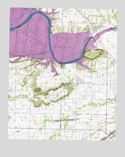
Robert S Kerr Dam, OK USGS Topographic Map
Click on map above to begin viewing in our Map Viewer.

This topographic map contains these locations and features:
Feature Name Type Latitude Longitude GNIS ID View Map
Blaine BottomBendN35.3448°W94.8536°1090244View Map
BrentCivilN35.3640°W94.7881°2631075View Map
BrentPopulated PlaceN35.3679°W94.7936°1853457View Map
Brent CemeteryCemeteryN35.3737°W94.7727°1090466View Map
Brent Census Designated PlaceCensusN35.3640°W94.7880°2407901View Map
Brent Volunteer Fire DepartmentBuildingN35.3669°W94.7865°2657213View Map
Brushy KnobSummitN35.2970°W94.8402°1090576View Map
Cache CemeteryCemeteryN35.2536°W94.8217°2724213View Map
Cowlington CemeteryCemeteryN35.3104°W94.7783°1091785View Map
Cowlington Volunteer Fire DepartmentBuildingN35.3069°W94.7875°2657254View Map
Gingle MountainSummitN35.2923°W94.8186°1093190View Map
McCann CreekStreamN35.3301°W94.8255°1095209View Map
McCann MountainSummitN35.3209°W94.8499°1095210View Map
Negro CreekStreamN35.3657°W94.7513°1095772View Map
Robert S Kerr DamDamN35.3498°W94.7802°1097252View Map
Robert S Kerr Lock and Dam 15DamN35.3468°W94.7769°1751386View Map
Robert S Kerr Lock and Dam 15ReservoirN35.3468°W94.7769°1751387View Map
Sallisaw CreekStreamN35.3723°W94.8433°1097663View Map
Sans BoisCivilN35.2918°W94.8572°1101899View Map
Short MountainSummitN35.3282°W94.7794°1098023View Map
Short Mountain CemeteryCemeteryN35.3151°W94.7736°1098026View Map
StarPopulated PlaceN35.3112°W94.8650°1100851View Map
Star CemeteryCemeteryN35.3133°W94.8630°2709106View Map
Town of CowlingtonCivilN35.3106°W94.7879°2412380View Map
Township of BrentCivilN35.3668°W94.7808°1824617View Map
Township of CowlingtonCivilN35.2945°W94.7613°1824666View Map

Note: Coordinates in the location and feature list above are referenced to NAD83 datum.


Copyright (C) 2008-2024 Ryan Niemi / Sunset Dynamics ... All Rights Reserved