TopoQuest Logo
Do you find TopoQuest useful?
Help keep TopoQuest running and adding new maps/features by donating!
Bitcoin:  19c7KJd3qBynnjoSw5npx9KScwjBe4ifkT
Litecoin:  LXs6TkuXGGXo1vDsWCkWVdjQX94eUKd6ui
Home View Maps Find Maps Find Places Resources & Links


Rochester, Wisconsin Topographic Map

USGS Map Title: Rochester, WI
USGS Map MRC: 42088F2
DRG (GeoTIFF) Download: o42088f2.tif


Neighboring USGS Topographic Map Quads:


  Mukwonago, WI  
42088G3
 

  Waterford, WI  
42088G2
 

  North Cape, WI  
42088G1
 

  Burlington, WI  
42088F3
 

  Rochester, WI  
42088F2
 

  Union Grove, WI  
42088F1
 

  Genoa City, WI  
42088E3
 

  Silver Lake, WI  
42088E2
 

  Paddock Lake, WI  
42088E1


Map MRC Location:

N43°
W89°
N43°
W88°
H8 H7 H6 H5 H4 H3 H2 H1
G8 G7 G6 G5 G4 G3 G2 G1
F8 F7 F6 F5 F4 F3 F2 F1
E8 E7 E6 E5 E4 E3 E2 E1
D8 D7 D6 D5 D4 D3 D2 D1
C8 C7 C6 C5 C4 C3 C2 C1
B8 B7 B6 B5 B4 B3 B2 B1
A8 A7 A6 A5 A4 A3 A2 A1
N42°
W89°
N42°
W88°

Rochester, WI USGS 1:24K Topographic Map Preview:
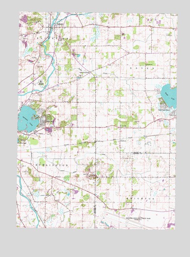
Rochester, WI USGS Topographic Map
Click on map above to begin viewing in our Map Viewer.

This topographic map contains these locations and features:
Feature Name Type Latitude Longitude GNIS ID View Map
420 ReservoirReservoirN42.6617°W88.2268°1793460View Map
Brightonwoods OrchardLocaleN42.6433°W88.1611°2516917View Map
Browns LakePopulated PlaceN42.6925°W88.2312°1867654View Map
Browns LakeLakeN42.6877°W88.2425°1562273View Map
Browns Lake Census Designated PlaceCensusN42.6908°W88.2309°2393353View Map
Browns Lake Mobile Home ParkPopulated PlaceN42.6786°W88.2353°2508613View Map
Camp MacLeanLocaleN42.6759°W88.2479°1562633View Map
Cedar ParkPopulated PlaceN42.6889°W88.2306°1562862View Map
Cherry Lake Sedge Meadow State Natural AreaParkN42.7261°W88.2426°2059255View Map
Duckett SchoolSchoolN42.6545°W88.2198°1564158View Map
Eagle CreekStreamN42.7203°W88.2220°1564237View Map
Eagle LakePopulated PlaceN42.7070°W88.1281°1867656View Map
Eagle LakeLakeN42.7033°W88.1252°1564252View Map
Eagle Lake Census Designated PlaceCensusN42.7014°W88.1291°2392983View Map
Eagle Lake ManorPopulated PlaceN42.6984°W88.1351°1564253View Map
Eagle Lake TerracePopulated PlaceN42.7047°W88.1390°1850936View Map
Ela OrchardLocaleN42.7439°W88.2331°2516920View Map
English Settlement SchoolSchoolN42.7161°W88.1923°1564668View Map
Fischer ParkParkN42.6811°W88.2370°1564981View Map
Flaglor AirportAirportN42.6609°W88.1359°1582031View Map
Hillside School at LakeviewSchoolN42.7377°W88.1679°2716323View Map
Hoosier Branch CanalCanalN42.6439°W88.2204°1566669View Map
Hoosier CreekStreamN42.6339°W88.2343°1566670View Map
Hoosier Creek CanalCanalN42.6686°W88.1876°1566671View Map
Lakeview Rehabilitation CenterBuildingN42.7378°W88.1680°1850973View Map
Lewislynn Landing Field (historical)AirportN42.7375°W88.1348°1850963View Map
Lorimar EstatesPopulated PlaceN42.7114°W88.1273°1850964View Map
Mount TomSummitN42.6547°W88.1893°1569850View Map
Pan-Yak Golf CourseLocaleN42.7084°W88.1281°1850979View Map
Richard Bong Air Force Base (historical)MilitaryN42.6278°W88.1583°1850144View Map
Richard Bong State Recreation AreaParkN42.6316°W88.1385°2726405View Map
RochesterPopulated PlaceN42.7414°W88.2243°1572420View Map
Rochester 2WP427 DamDamN42.6617°W88.2268°1793459View Map
Rochester CemeteryCemeteryN42.7447°W88.2379°1572421View Map
Rochester Volunteer Fire and Rescue CompanyBuildingN42.7390°W88.2296°2697629View Map
Rodgers LakeLakeN42.6448°W88.2091°2764478View Map
RosewoodPopulated PlaceN42.6759°W88.1687°1572615View Map
Rosewood SchoolSchoolN42.6845°W88.1684°1572616View Map
Saint Francis MonasteryChurchN42.7100°W88.2318°1572940View Map
Sunnyside Elementary SchoolSchoolN42.7209°W88.1493°1575097View Map
Town of BrightonCivilN42.6262°W88.1296°1582859View Map
Town of BurlingtonCivilN42.6589°W88.2420°1582889View Map
Town of DoverCivilN42.7132°W88.1302°1583094View Map
Town of Rochester (historical)CivilN42.7409°W88.2440°1584047View Map
Village of RochesterCivilN42.7338°W88.2488°1584046View Map
Western Racine Wastewater Treatment PlantLocaleN42.7261°W88.2261°2354995View Map

Note: Coordinates in the location and feature list above are referenced to NAD83 datum.


Copyright (C) 2008-2024 Ryan Niemi / Sunset Dynamics ... All Rights Reserved