TopoQuest Logo
Do you find TopoQuest useful?
Help keep TopoQuest running and adding new maps/features by donating!
Bitcoin:  19c7KJd3qBynnjoSw5npx9KScwjBe4ifkT
Litecoin:  LXs6TkuXGGXo1vDsWCkWVdjQX94eUKd6ui
Home View Maps Find Maps Find Places Resources & Links


Rock Harbor, Florida Topographic Map

USGS Map Title: Rock Harbor, FL
USGS Map MRC: 25080A4
DRG (GeoTIFF) Download: o25080a4.tif


Neighboring USGS Topographic Map Quads:


  Blackwater Sound, FL  
25080B4
 

  Garden Cove, FL  
25080B3


  Rock Harbor, FL  
25080A4


Map MRC Location:

N26°
W81°
N26°
W80°
H8 H7 H6 H5 H4 H3 H2 H1
G8 G7 G6 G5 G4 G3 G2 G1
F8 F7 F6 F5 F4 F3 F2 F1
E8 E7 E6 E5 E4 E3 E2 E1
D8 D7 D6 D5 D4 D3 D2 D1
C8 C7 C6 C5 C4 C3 C2 C1
B8 B7 B6 B5 B4 B3 B2 B1
A8 A7 A6 A5 A4 A3 A2 A1
N25°
W81°
N25°
W80°

Rock Harbor, FL USGS 1:24K Topographic Map Preview:
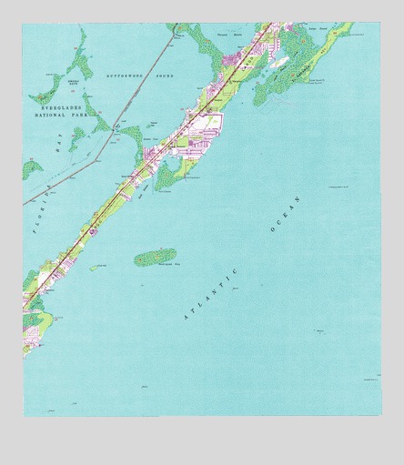
Rock Harbor, FL USGS Topographic Map
Click on map above to begin viewing in our Map Viewer.

This topographic map contains these locations and features:
Feature Name Type Latitude Longitude GNIS ID View Map
American Outdoors MarinaHarborN25.0748°W80.4651°2449920View Map
Baker CutChannelN25.0910°W80.4673°278051View Map
Blue Fin Rock Harbor MarinaHarborN25.0735°W80.4599°2449921View Map
Burton Memorial United Methodist ChurchChurchN25.0504°W80.4789°301895View Map
Buttonwood SoundBayN25.1110°W80.4580°279757View Map
Church of GodChurchN25.1032°W80.4359°301900View Map
Church of the NazareneChurchN25.0851°W80.4359°301894View Map
Coastal Waterway Park Mobile Home ParkPopulated PlaceN25.1141°W80.4257°2449936View Map
Coral Isles ChurchChurchN25.0351°W80.4914°301892View Map
Dove CreekGutN25.0357°W80.4953°281731View Map
Dove KeyIslandN25.0476°W80.4751°281732View Map
El Radabob KeyIslandN25.1235°W80.3881°282133View Map
First Baptist ChurchChurchN25.0935°W80.4498°301902View Map
First Baptist Church of Key LargoChurchN25.0881°W80.4463°2449938View Map
Getman Memorial ChurchChurchN25.0860°W80.4492°283046View Map
Grouper CreekGutN25.1240°W80.4456°283469View Map
Immanuel Lutheran ChurchChurchN25.0837°W80.4539°301896View Map
Jehovahs Witnesses ChurchChurchN25.0865°W80.4359°301897View Map
John Pennekamp Coral Reef State ParkParkN25.1207°W80.4045°1946107View Map
Key LargoPopulated PlaceN25.0865°W80.4473°294458View Map
Key Largo Baptist TempleChurchN25.0990°W80.4414°301901View Map
Key Largo Census Designated PlaceCensusN25.1230°W80.4113°2403172View Map
Key Largo Christian AcademySchoolN25.0832°W80.4567°303761View Map
Key Largo ParkPopulated PlaceN25.1046°W80.4331°299996View Map
Key Largo Post OfficePost OfficeN25.0993°W80.4365°2783379View Map
Key Largo Volunteer Ambulance CorpsBuildingN25.0841°W80.4520°2131722View Map
Key Largo Volunteer Ambulance CorpsBuildingN25.0840°W80.4520°2661744View Map
Key Largo Volunteer Fire Rescue Station 24BuildingN25.0896°W80.4445°2131725View Map
Long PointCapeN25.0324°W80.4898°286029View Map
Lower Sound PointCapeN25.1071°W80.4001°286177View Map
Mandalay MarinaHarborN25.0735°W80.4599°2449926View Map
Mariners ClubHarborN25.0729°W80.4614°2449927View Map
Molasses Reef ChannelChannelN25.0237°W80.3814°308482View Map
Molasses Reef LightLocaleN25.0118°W80.3762°287050View Map
Monroe County Public Library System Key Largo BranchBuildingN25.1124°W80.4219°2449917View Map
Mosquito Bank Light Number 35LocaleN25.0732°W80.3928°287172View Map
NewportPopulated PlaceN25.1040°W80.4312°287720View Map
Paradise Point Mobile Home ParkPopulated PlaceN25.0437°W80.4898°2449937View Map
Pelican KeyIslandN25.0929°W80.4553°288674View Map
Pilot House MarinaHarborN25.0878°W80.4411°2449930View Map
Point CharlesCapeN25.0726°W80.4526°289118View Map
Riptide Trailer ParkPopulated PlaceN25.0767°W80.4618°2449933View Map
Rock HarborBayN25.0737°W80.4564°289819View Map
Rock HarborPopulated PlaceN25.0768°W80.4603°289820View Map
Rock Harbor MarinaHarborN25.0735°W80.4600°2449931View Map
Rock Harbor Marina East Mobile Home ParkPopulated PlaceN25.0741°W80.4607°2449934View Map
Rodriguez KeyIslandN25.0510°W80.4539°289919View Map
Saint James the Fisherman ChurchChurchN25.0879°W80.4303°301899View Map
Saint James the Fisherman Episcopal ChurchChurchN25.0754°W80.4914°301898View Map
Saint Justin Martyr Catholic ChurchChurchN25.1046°W80.4151°301903View Map
Saint Margarets ChurchChurchN25.1068°W80.4278°290280View Map
Shell KeyIslandN25.1023°W80.4906°290980View Map
South CreekGutN25.1110°W80.4073°291362View Map
South Sound CreekStreamN25.1026°W80.4142°294391View Map
Sunset CoveBayN25.0915°W80.4516°291862View Map
Sunset PointCapeN25.0504°W80.4914°299998View Map
Sunset PointPopulated PlaceN25.0476°W80.4901°304729View Map
Swash KeysIslandN25.1104°W80.4834°291928View Map
Tarpon BasinBasinN25.1235°W80.4276°292033View Map
Tavernier Towne II Shopping CenterLocaleN25.0746°W80.4626°296372View Map
ThompsonPopulated PlaceN25.0424°W80.4926°292218View Map
Travel Trailer TownPopulated PlaceN25.0591°W80.4752°2449935View Map
TrianglesBarN25.0087°W80.4498°294380View Map
Universal Life ChurchChurchN25.0504°W80.4817°301893View Map
Upper Keys DivisionCivilN25.0829°W80.4507°1935959View Map
Waldorf PlazaLocaleN25.1148°W80.4214°296371View Map
White Bank Dry RocksBarN25.0387°W80.3831°308483View Map
WKEB-TV (Islamorada)TowerN25.0918°W80.4434°309180View Map
WKLG-FM (Rock Harbor)TowerN25.0918°W80.4434°309118View Map
WZMQ-FM (Key Largo)TowerN25.0918°W80.4434°309027View Map

Note: Coordinates in the location and feature list above are referenced to NAD83 datum.


Copyright (C) 2008-2025 Ryan Niemi / Sunset Dynamics ... All Rights Reserved