TopoQuest Logo
Do you find TopoQuest useful?
Help keep TopoQuest running and adding new maps/features by donating!
Bitcoin:  19c7KJd3qBynnjoSw5npx9KScwjBe4ifkT
Litecoin:  LXs6TkuXGGXo1vDsWCkWVdjQX94eUKd6ui
Home View Maps Find Maps Find Places Resources & Links


Big Sandy Opening, Wyoming Topographic Map

USGS Map Title: Big Sandy Opening, WY
USGS Map MRC: 42109F3
DRG (GeoTIFF) Download: o42109f3.tif


Neighboring USGS Topographic Map Quads:


  Raid Lake, WY  
42109G4
 

  Mount Bonneville, WY  
42109G3
 

  Lizard Head Peak, WY  
42109G2
 

  Pocket Creek Lake, WY  
42109F4
 

  Big Sandy Opening, WY  
42109F3
 

  Temple Peak, WY  
42109F2
 

  Leckie SW, WY  
42109E4
 

  Leckie, WY  
42109E3
 

  Jensen Meadows, WY  
42109E2


Map MRC Location:

N43°
W110°
N43°
W109°
H8 H7 H6 H5 H4 H3 H2 H1
G8 G7 G6 G5 G4 G3 G2 G1
F8 F7 F6 F5 F4 F3 F2 F1
E8 E7 E6 E5 E4 E3 E2 E1
D8 D7 D6 D5 D4 D3 D2 D1
C8 C7 C6 C5 C4 C3 C2 C1
B8 B7 B6 B5 B4 B3 B2 B1
A8 A7 A6 A5 A4 A3 A2 A1
N42°
W110°
N42°
W109°

Big Sandy Opening, WY USGS 1:24K Topographic Map Preview:
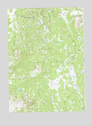
Big Sandy Opening, WY USGS Topographic Map
Click on map above to begin viewing in our Map Viewer.

This topographic map contains these locations and features:
Feature Name Type Latitude Longitude GNIS ID View Map
Beaver CreekStreamN42.6733°W109.3251°1598051View Map
Beaver LakeLakeN42.7077°W109.3150°1598077View Map
Big Sandy CampgroundLocaleN42.6869°W109.2718°1598165View Map
Big Sandy LodgeLocaleN42.6827°W109.2779°1608741View Map
Big Sandy OpeningSwampN42.6651°W109.2690°1598168View Map
Boulter DamDamN42.7249°W109.3124°1607883View Map
Boulter LakeLakeN42.7253°W109.3112°1598328View Map
Boulter ReservoirReservoirN42.7253°W109.3112°1607884View Map
Boundary CreekStreamN42.7238°W109.3449°1598329View Map
Boundary Creek TrailTrailN42.7458°W109.3632°1604843View Map
Dads CreekStreamN42.7449°W109.2968°1599102View Map
Diamond Lake TrailTrailN42.7152°W109.2585°1597578View Map
Divide LakeLakeN42.7313°W109.2724°1599269View Map
Fish CreekStreamN42.7472°W109.3201°1599717View Map
Fish Creek ParkFlatN42.7433°W109.2826°1599727View Map
Fish LakeLakeN42.7406°W109.2626°1599728View Map
Francis LakeLakeN42.7465°W109.3081°1599840View Map
Francis Lake TailTrailN42.7452°W109.3051°1604750View Map
Fremout DrivewayTrailN42.6277°W109.2757°1604749View Map
Highline TrailTrailN42.7497°W109.3254°1600335View Map
Irish CanyonValleyN42.6649°W109.3454°1600521View Map
Iron CreekStreamN42.6741°W109.2729°1600527View Map
Iron Creek MeadowsSwampN42.6986°W109.2740°1600531View Map
Johnson LakeLakeN42.6760°W109.2897°1600644View Map
Lamreaux MeadowsSwampN42.6562°W109.3039°1600826View Map
Legion LakeLakeN42.7408°W109.3090°1600885View Map
Meeks LakeLakeN42.7033°W109.2675°1601348View Map
Mirror LakeLakeN42.7473°W109.2831°1601489View Map
Mud LakeLakeN42.6839°W109.2799°1601603View Map
Muddy LakeLakeN42.6510°W109.3575°1601620View Map
Poston LakeLakeN42.7394°W109.3355°1602284View Map
Poston MeadowsSwampN42.7332°W109.3203°1602285View Map
South Temple CreekStreamN42.6619°W109.2699°1603203View Map
Temple Creek Summer Home AreaPopulated PlaceN42.6672°W109.2632°1604741View Map
Twin LakesLakeN42.7089°W109.2907°1603830View Map
V LakeLakeN42.7113°W109.2569°1603893View Map
Wheeler Ranch TrailTrailN42.7119°W109.3635°1604117View Map
Willow CreekStreamN42.6719°W109.3246°1604196View Map

Note: Coordinates in the location and feature list above are referenced to NAD83 datum.


Copyright (C) 2008-2024 Ryan Niemi / Sunset Dynamics ... All Rights Reserved