TopoQuest Logo
Do you find TopoQuest useful?
Help keep TopoQuest running and adding new maps/features by donating!
Bitcoin:  19c7KJd3qBynnjoSw5npx9KScwjBe4ifkT
Litecoin:  LXs6TkuXGGXo1vDsWCkWVdjQX94eUKd6ui
Home View Maps Find Maps Find Places Resources & Links


Rockvale, Tennessee Topographic Map

USGS Map Title: Rockvale, TN
USGS Map MRC: 35086G5
DRG (GeoTIFF) Download: o35086g5.tif


Neighboring USGS Topographic Map Quads:


  Nolensville, TN  
35086H6
 

  Smyrna, TN  
35086H5
 

  Walterhill, TN  
35086H4
 

  College Grove, TN  
35086G6
 

  Rockvale, TN  
35086G5
 

  Murfreesboro, TN  
35086G4
 

  Chapel Hill, TN  
35086F6
 

  Rover, TN  
35086F5
 

  Fosterville, TN  
35086F4


Map MRC Location:

N36°
W87°
N36°
W86°
H8 H7 H6 H5 H4 H3 H2 H1
G8 G7 G6 G5 G4 G3 G2 G1
F8 F7 F6 F5 F4 F3 F2 F1
E8 E7 E6 E5 E4 E3 E2 E1
D8 D7 D6 D5 D4 D3 D2 D1
C8 C7 C6 C5 C4 C3 C2 C1
B8 B7 B6 B5 B4 B3 B2 B1
A8 A7 A6 A5 A4 A3 A2 A1
N35°
W87°
N35°
W86°

Rockvale, TN USGS 1:24K Topographic Map Preview:
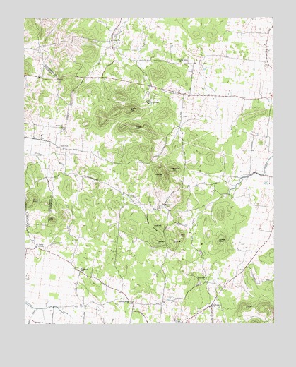
Rockvale, TN USGS Topographic Map
Click on map above to begin viewing in our Map Viewer.

This topographic map contains these locations and features:
Feature Name Type Latitude Longitude GNIS ID View Map
AlmavillePopulated PlaceN35.8653°W86.5811°1275629View Map
Almaville Fire Department Station 1BuildingN35.8683°W86.5797°2654037View Map
Almaville School (historical)SchoolN35.8684°W86.5797°1323450View Map
Baskin CemeteryCemeteryN35.8220°W86.5555°1645522View Map
Batey CemeteryCemeteryN35.8423°W86.5153°1645524View Map
Batey CemeteryCemeteryN35.8517°W86.5164°1645525View Map
Blackman CemeteryCemeteryN35.8703°W86.5072°1645538View Map
Blackman CemeteryCemeteryN35.8598°W86.5133°1645539View Map
Blue SinkBasinN35.7976°W86.6217°1645542View Map
Bowen-Snell CemeteryCemeteryN35.8317°W86.6122°1645545View Map
Brothers CemeteryCemeteryN35.8092°W86.5005°1645555View Map
Burns CemeteryCemeteryN35.7639°W86.5755°1645561View Map
Carlton CemeteryCemeteryN35.7662°W86.5330°1645567View Map
Carlton CemeteryCemeteryN35.7606°W86.5533°1279680View Map
Cedar GrovePopulated PlaceN35.7812°W86.6194°1280028View Map
Cedar Grove ChurchChurchN35.8567°W86.5475°1280044View Map
Cedar Grove School (historical)SchoolN35.7842°W86.6208°1323466View Map
Cocke CemeteryCemeteryN35.7823°W86.5019°1645584View Map
Cole KnobSummitN35.7928°W86.6108°1280933View Map
Comer CemeteryCemeteryN35.7901°W86.5447°1645585View Map
Comer CemeteryCemeteryN35.7537°W86.5283°1645586View Map
Commissioner District 20CivilN35.8560°W86.5334°2463993View Map
Concord CreekStreamN35.7565°W86.6189°1281072View Map
CrestwoodPopulated PlaceN35.8420°W86.5378°1313045View Map
Downing CemeteryCemeteryN35.8223°W86.6075°1645613View Map
Downing CemeteryCemeteryN35.7687°W86.6236°1645614View Map
Dyer CemeteryCemeteryN35.7837°W86.5697°1283257View Map
Eagleville Division (historical)CensusN35.7503°W86.6111°1648934View Map
Ellis FieldAirportN35.7794°W86.5830°2675510View Map
Fain HillSummitN35.7862°W86.5472°1283965View Map
FoxridgePopulated PlaceN35.8417°W86.5186°1313063View Map
Freeman CemeteryCemeteryN35.8312°W86.6028°1645653View Map
Garrett KnobSummitN35.7567°W86.5147°1285202View Map
Gibson AirportAirportN35.7682°W86.5487°2675511View Map
Glen CemeteryCemeteryN35.8648°W86.5875°1645660View Map
Glenn-Windrow CemeteryCemeteryN35.8353°W86.6036°1645661View Map
Haley CemeteryCemeteryN35.7889°W86.6244°1645669View Map
Harris CemeteryCemeteryN35.8006°W86.5200°1645680View Map
Haynes CemeteryCemeteryN35.8564°W86.5353°1645685View Map
Haynes CemeteryCemeteryN35.8612°W86.5347°1645686View Map
Haynes CemeteryCemeteryN35.8376°W86.5722°1645687View Map
Hill CemeteryCemeteryN35.8134°W86.5950°1645692View Map
Indian MountainSummitN35.8301°W86.5692°1288995View Map
Jackson CemeteryCemeteryN35.7526°W86.5792°1645710View Map
Jackson CemeteryCemeteryN35.7573°W86.6000°1645711View Map
Jackson RidgePopulated PlaceN35.7603°W86.5736°1647689View Map
Jackson Ridge Camp Ground (historical)LocaleN35.7590°W86.5714°1323505View Map
Jackson Ridge CemeteryCemeteryN35.7587°W86.5722°1645712View Map
Jackson Ridge ChurchChurchN35.7587°W86.5722°1289244View Map
Jarratt CemeteryCemeteryN35.7837°W86.5044°1645720View Map
Jarrett KnobSummitN35.7834°W86.5278°1289308View Map
Kelly CreekStreamN35.7565°W86.6192°1290031View Map
Kingwood School (historical)SchoolN35.8367°W86.5014°1323510View Map
Lawrence Chapel School (historical)SchoolN35.7984°W86.5130°1323518View Map
Lawrence-Yeargin CemeteryCemeteryN35.8284°W86.6180°1645750View Map
Leathers HillSummitN35.7834°W86.5589°1290879View Map
Lock SchoolSchoolN35.8653°W86.5881°1291756View Map
Lockwood LakeLakeN35.8403°W86.5615°1291780View Map
Love CemeteryCemeteryN35.7539°W86.5392°1645758View Map
Lytlel-Banks CemeteryCemeteryN35.8417°W86.5305°1645766View Map
Manire CemeteryCemeteryN35.7701°W86.5975°1645775View Map
Manning CemeteryCemeteryN35.7551°W86.5505°1645778View Map
McClaren-Marable CemeteryCemeteryN35.8392°W86.5978°1645791View Map
McCord KnobSummitN35.7998°W86.6219°1293189View Map
McNeil FarmsPopulated PlaceN35.8420°W86.5272°1313117View Map
OakwoodPopulated PlaceN35.8415°W86.5042°1313132View Map
Overall SpringsSpringN35.8028°W86.5222°1645850View Map
Palmore CemeteryCemeteryN35.8742°W86.6175°1296704View Map
Pate CemeteryCemeteryN35.8139°W86.6100°1645857View Map
PattersonPopulated PlaceN35.8231°W86.6094°1315682View Map
Patterson Baptist ChurchChurchN35.8215°W86.6053°1645858View Map
Patterson School (historical)SchoolN35.8215°W86.6039°1652157View Map
Pleasant HillPopulated PlaceN35.7715°W86.5972°1315733View Map
Primm CemeteryCemeteryN35.8084°W86.5447°1645879View Map
Raney CemeteryCemeteryN35.8267°W86.6019°1645885View Map
Ransom CemeteryCemeteryN35.7987°W86.5061°1645886View Map
Red HillSummitN35.7898°W86.5558°1299053View Map
Rehobeth ChurchChurchN35.8306°W86.6056°1299199View Map
RockvalePopulated PlaceN35.7573°W86.5314°1299832View Map
Rockvale Census Designated PlaceCensusN35.7681°W86.5197°2584591View Map
Rockvale ChurchChurchN35.7678°W86.5347°1299833View Map
Rockvale Elementary SchoolSchoolN35.7501°W86.5464°1648480View Map
Rockvale Post OfficePost OfficeN35.7686°W86.5214°1652161View Map
Rockvale Volunteer Fire Department Station 1 HeadquartersBuildingN35.7579°W86.5307°2653687View Map
Rowland Hill CemeteryCemeteryN35.7803°W86.5508°1645906View Map
Rowling HillSummitN35.7831°W86.5511°1300207View Map
Rutledge HollowValleyN35.7966°W86.5647°1300366View Map
Scales MountainSummitN35.8376°W86.5728°1300862View Map
Snail Shell Cave SpringSpringN35.7826°W86.5361°1652166View Map
Snell (historical)Populated PlaceN35.8434°W86.5417°1313170View Map
Snell CemeteryCemeteryN35.8345°W86.5450°1645947View Map
Snell CemeteryCemeteryN35.8131°W86.5194°1645948View Map
Snell-Newman CemeteryCemeteryN35.8087°W86.5380°1645949View Map
Sophie HillSummitN35.8128°W86.5514°1270822View Map
Spann CemeteryCemeteryN35.8645°W86.6072°1645951View Map
The GulfBasinN35.7731°W86.5742°1645668View Map
Toombs CemeteryCemeteryN35.8673°W86.6014°1645968View Map
Townsel HillSummitN35.8103°W86.5555°1272812View Map
Triune AirfieldAirportN35.8066°W86.6122°2675509View Map
Tucker CemeteryCemeteryN35.7503°W86.5439°1645971View Map
Vaughan CemeteryCemeteryN35.8637°W86.5786°1645978View Map
Wade CemeteryCemeteryN35.7823°W86.5164°1645983View Map
Watson-Rowland CemeteryCemeteryN35.8037°W86.5592°1645997View Map
Watson-Vaughn CemeteryCemeteryN35.8178°W86.5594°1645998View Map
West CemeteryCemeteryN35.7837°W86.5805°1646004View Map
WindrowPopulated PlaceN35.7987°W86.5550°1314521View Map
Windrow BranchStreamN35.8070°W86.5792°1274863View Map
Windrow Church CemeteryCemeteryN35.7981°W86.5536°1646018View Map
Windrow Community CemeteryCemeteryN35.7973°W86.5547°1646019View Map
Windrows Camp Ground (historical)LocaleN35.7978°W86.5542°1323591View Map
Wood CemeteryCemeteryN35.8734°W86.5753°1646022View Map
Wray-Covington CemeteryCemeteryN35.8451°W86.5505°1646025View Map

Note: Coordinates in the location and feature list above are referenced to NAD83 datum.


Copyright (C) 2008-2025 Ryan Niemi / Sunset Dynamics ... All Rights Reserved