TopoQuest Logo
Do you find TopoQuest useful?
Help keep TopoQuest running and adding new maps/features by donating!
Bitcoin:  19c7KJd3qBynnjoSw5npx9KScwjBe4ifkT
Litecoin:  LXs6TkuXGGXo1vDsWCkWVdjQX94eUKd6ui
Home View Maps Find Maps Find Places Resources & Links


Rooster Comb, Oregon Topographic Map

USGS Map Title: Rooster Comb, OR
USGS Map MRC: 43117C3
DRG (GeoTIFF) Download: o43117c3.tif


Neighboring USGS Topographic Map Quads:


  Quartz Mountain Basin, OR  
43117D4
 

  Pelican Point, OR  
43117D3
 

  Three Fingers Rock, OR  
43117D2
 

  Diamond Butte, OR  
43117C4
 

  Rooster Comb, OR  
43117C3
 

  Bannock Ridge, OR  
43117C2
 

  Jordan Craters North, OR  
43117B4
 

  McCain Creek, OR  
43117B3
 

  Mahogany Gap, OR  
43117B2


Map MRC Location:

N44°
W118°
N44°
W117°
H8 H7 H6 H5 H4 H3 H2 H1
G8 G7 G6 G5 G4 G3 G2 G1
F8 F7 F6 F5 F4 F3 F2 F1
E8 E7 E6 E5 E4 E3 E2 E1
D8 D7 D6 D5 D4 D3 D2 D1
C8 C7 C6 C5 C4 C3 C2 C1
B8 B7 B6 B5 B4 B3 B2 B1
A8 A7 A6 A5 A4 A3 A2 A1
N43°
W118°
N43°
W117°

Rooster Comb, OR USGS 1:24K Topographic Map Preview:
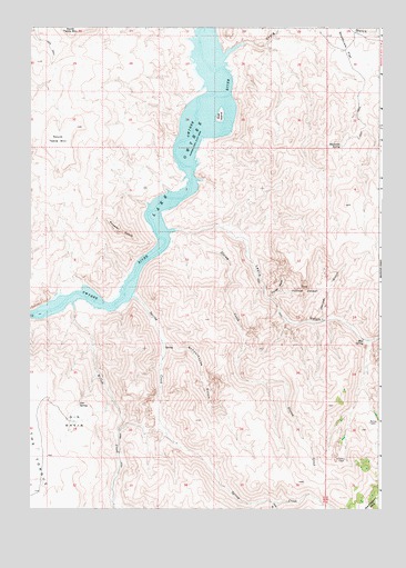
Rooster Comb, OR USGS Topographic Map
Click on map above to begin viewing in our Map Viewer.

This topographic map contains these locations and features:
Feature Name Type Latitude Longitude GNIS ID View Map
Barnes CabinLocaleN43.2727°W117.2538°1157822View Map
Craig GulchValleyN43.3699°W117.3010°1119500View Map
Dago GulchValleyN43.2938°W117.2552°1130099View Map
Doe IslandIslandN43.3532°W117.3079°1120002View Map
Gin BasinBasinN43.2724°W117.3596°1121140View Map
Gin Basin ReservoirReservoirN43.2723°W117.3586°1157797View Map
Gin SpringSpringN43.2769°W117.3577°1121141View Map
Hon GulchValleyN43.2513°W117.2888°1121952View Map
Juniper GulchValleyN43.2988°W117.2710°1122591View Map
Leslie GulchValleyN43.3218°W117.3238°1123049View Map
Leslie Gulch Boat RampLocaleN43.3221°W117.3263°2700035View Map
Leslie Gulch CampLocaleN43.3235°W117.3249°1130098View Map
Mud SpringSpringN43.2941°W117.2558°1124480View Map
Rooster CombSummitN43.3215°W117.3440°1126281View Map
Runaway CreekStreamN43.2943°W117.2521°1126359View Map
Schaffer CabinLocaleN43.2629°W117.2632°1126638View Map
Schoolhouse GulchValleyN43.2935°W117.3285°1126663View Map
Shadscale FlatFlatN43.3688°W117.2629°1126775View Map
Shadscale SpringSpringN43.3443°W117.2647°1126776View Map
Slocum CreekStreamN43.3221°W117.3210°1127090View Map
South Table MountainSummitN43.3457°W117.3691°1136767View Map
Spring CreekStreamN43.3049°W117.3390°1127426View Map
Spring Creek CampLocaleN43.3063°W117.3363°1130097View Map
The TongueSummitN43.2599°W117.3735°1161550View Map
The Yellow JacketAreaN43.3063°W117.2779°1128000View Map
Timber GulchValleyN43.3049°W117.2904°1158521View Map
Willow CreekStreamN43.3024°W117.3599°1129144View Map

Note: Coordinates in the location and feature list above are referenced to NAD83 datum.


Copyright (C) 2008-2025 Ryan Niemi / Sunset Dynamics ... All Rights Reserved