TopoQuest Logo
Do you find TopoQuest useful?
Help keep TopoQuest running and adding new maps/features by donating!
Bitcoin:  19c7KJd3qBynnjoSw5npx9KScwjBe4ifkT
Litecoin:  LXs6TkuXGGXo1vDsWCkWVdjQX94eUKd6ui
Home View Maps Find Maps Find Places Resources & Links


Rossburg, Ohio Topographic Map

USGS Map Title: Rossburg, OH
USGS Map MRC: 40084C6
DRG (GeoTIFF) Download: o40084c6.tif


Neighboring USGS Topographic Map Quads:


  Fort Recovery, OH  
40084D7
 

  Coldwater, OH  
40084D6
 

  Montezuma, OH  
40084D5
 

  Cosmos, OH  
40084C7
 

  Rossburg, OH  
40084C6
 

  North Star, OH  
40084C5
 

  Union City, IN  
40084B7
 

  Ansonia, OH  
40084B6
 

  Dawn, OH  
40084B5


Map MRC Location:

N41°
W85°
N41°
W84°
H8 H7 H6 H5 H4 H3 H2 H1
G8 G7 G6 G5 G4 G3 G2 G1
F8 F7 F6 F5 F4 F3 F2 F1
E8 E7 E6 E5 E4 E3 E2 E1
D8 D7 D6 D5 D4 D3 D2 D1
C8 C7 C6 C5 C4 C3 C2 C1
B8 B7 B6 B5 B4 B3 B2 B1
A8 A7 A6 A5 A4 A3 A2 A1
N40°
W85°
N40°
W84°

Rossburg, OH USGS 1:24K Topographic Map Preview:
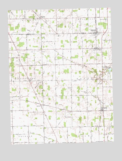
Rossburg, OH USGS Topographic Map
Click on map above to begin viewing in our Map Viewer.

This topographic map contains these locations and features:
Feature Name Type Latitude Longitude GNIS ID View Map
Bar-E Club LakeReservoirN40.3173°W84.6277°1078070View Map
Bar-E Club Lake DamDamN40.3184°W84.6283°1078069View Map
Berkettsville Post OfficePost OfficeN40.3514°W84.6416°2036686View Map
Broering FarmLocaleN40.3358°W84.6681°2711007View Map
BurkettsvillePopulated PlaceN40.3520°W84.6422°1060909View Map
Burkettsville Community Fire DepartmentBuildingN40.3516°W84.6443°2549620View Map
Burkettsville Elementary SchoolSchoolN40.3514°W84.6466°1055501View Map
Eldora SpeedwayLocaleN40.3187°W84.6336°1080089View Map
Fairview CemeteryCemeteryN40.3284°W84.6933°1040331View Map
Fields FarmsLocaleN40.2594°W84.7028°2711019View Map
Fortkamp FarmLocaleN40.3386°W84.7481°2711061View Map
Goulder School (historical)SchoolN40.3667°W84.7480°1077587View Map
Guggenbiller FarmsLocaleN40.3681°W84.6972°2711054View Map
Harrod FarmsLocaleN40.2700°W84.6928°2711018View Map
Hiestand ChurchChurchN40.3012°W84.6750°1041539View Map
Hiestand Community HallBuildingN40.3084°W84.6677°1041540View Map
Hoschover CemeteryCemeteryN40.2631°W84.6333°1041810View Map
Kaiser FarmLocaleN40.3731°W84.7050°2708262View Map
L M Swine FarmLocaleN40.3158°W84.6958°2710999View Map
LightsvillePopulated PlaceN40.2853°W84.7127°1048915View Map
Lightsville Post Office (historical)Post OfficeN40.2848°W84.7125°1968183View Map
Livingston FarmLocaleN40.2903°W84.7364°2711005View Map
Meiring FarmsLocaleN40.3625°W84.7131°2711052View Map
Meiring Poultry FarmLocaleN40.3650°W84.7275°2711074View Map
New Rose Hill CemeteryCemeteryN40.3117°W84.7269°1806180View Map
New WestonPopulated PlaceN40.3373°W84.6433°1065141View Map
New Weston Post OfficePost OfficeN40.3375°W84.6430°1967973View Map
Old Rose Hill CemeteryCemeteryN40.3117°W84.7280°1806184View Map
Rose HillPopulated PlaceN40.3087°W84.7255°1057969View Map
Rosehill Post Office (historical)Post OfficeN40.3084°W84.7250°1968197View Map
Ross LateralCanalN40.2553°W84.6519°1067527View Map
RossburgPopulated PlaceN40.2789°W84.6375°1057972View Map
Rossburg Fire DepartmentBuildingN40.2792°W84.6375°2550043View Map
Rossburg Post OfficePost OfficeN40.2792°W84.6375°1967977View Map
Rossburg United Methodist ChurchChurchN40.2798°W84.6383°1051889View Map
Saint Bernard Catholic ChurchChurchN40.3523°W84.6461°1069697View Map
Saint Bernard CemeteryCemeteryN40.3495°W84.6450°1045406View Map
Saint Marys CemeteryCemeteryN40.3609°W84.6306°1045642View Map
Saint Marys NovitiateSchoolN40.3645°W84.6308°1045671View Map
Saint Pauls Catholic CemeteryCemeteryN40.3670°W84.7119°1961402View Map
Saint Pauls Catholic ChurchChurchN40.3673°W84.7116°1069700View Map
Schrader FarmsLocaleN40.3097°W84.6386°2711017View Map
SharpsburgPopulated PlaceN40.3678°W84.7097°1061199View Map
Sharpsburg Elementary SchoolSchoolN40.3678°W84.7116°1054937View Map
Siefring Poultry FarmLocaleN40.3367°W84.7211°2711010View Map
Snyder FarmLocaleN40.3731°W84.7208°2711049View Map
South Fork Stillwater RiverStreamN40.2528°W84.6975°1066213View Map
Sutter FarmLocaleN40.3586°W84.6919°2711051View Map
Township of AllenCivilN40.3084°W84.6641°1086010View Map
Upper Wabash Structure Number Two DamDamN40.3634°W84.6833°1078856View Map
Upper Wabash Structure Number Two ReservoirReservoirN40.3634°W84.6833°1078857View Map
Village of BurkettsvilleCivilN40.3531°W84.6425°2397499View Map
Village of New WestonCivilN40.3370°W84.6436°2399487View Map
Village of RossburgCivilN40.2802°W84.6383°2399126View Map
Wabash Conservancy District Structure ReservoirReservoirN40.3167°W84.6350°1078855View Map
Webster CemeteryCemeteryN40.2792°W84.6758°1047650View Map
Weitzel FarmLocaleN40.3322°W84.6950°2711006View Map
Zerby CemeteryCemeteryN40.2862°W84.6905°1048233View Map
Zion Pilgrim ChurchChurchN40.2814°W84.6861°1048287View Map

Note: Coordinates in the location and feature list above are referenced to NAD83 datum.


Copyright (C) 2008-2024 Ryan Niemi / Sunset Dynamics ... All Rights Reserved