TopoQuest Logo
Do you find TopoQuest useful?
Help keep TopoQuest running and adding new maps/features by donating!
Bitcoin:  19c7KJd3qBynnjoSw5npx9KScwjBe4ifkT
Litecoin:  LXs6TkuXGGXo1vDsWCkWVdjQX94eUKd6ui
Home View Maps Find Maps Find Places Resources & Links


Rough Mountain, New Mexico Topographic Map

USGS Map Title: Rough Mountain, NM
USGS Map MRC: 34105B6
DRG (GeoTIFF) Download: o34105b6.tif


Neighboring USGS Topographic Map Quads:


  Progresso SE, NM  
34105C7
 

  Cedarvale, NM  
34105C6
 

  Corona North, NM  
34105C5
 

  Pajaro Canyon, NM  
34105B7
 

  Rough Mountain, NM  
34105B6
 

  Corona South, NM  
34105B5
 

  Claunch SE, NM  
34105A7
 

  Tecolote Peak, NM  
34105A6
 

  Pelon Hill, NM  
34105A5


Map MRC Location:

N35°
W106°
N35°
W105°
H8 H7 H6 H5 H4 H3 H2 H1
G8 G7 G6 G5 G4 G3 G2 G1
F8 F7 F6 F5 F4 F3 F2 F1
E8 E7 E6 E5 E4 E3 E2 E1
D8 D7 D6 D5 D4 D3 D2 D1
C8 C7 C6 C5 C4 C3 C2 C1
B8 B7 B6 B5 B4 B3 B2 B1
A8 A7 A6 A5 A4 A3 A2 A1
N34°
W106°
N34°
W105°

Rough Mountain, NM USGS 1:24K Topographic Map Preview:
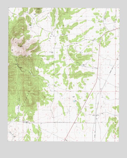
Rough Mountain, NM USGS Topographic Map
Click on map above to begin viewing in our Map Viewer.

This topographic map contains these locations and features:
Feature Name Type Latitude Longitude GNIS ID View Map
All American ProspectMineN34.2001°W105.7339°915421View Map
Bagley RanchLocaleN34.2376°W105.6438°903498View Map
Bates TankReservoirN34.2254°W105.6908°1926314View Map
Bates Trick TankReservoirN34.2051°W105.7228°1926321View Map
Big Ben ProspectMineN34.2001°W105.7339°916937View Map
Big LakeLakeN34.1628°W105.6758°1926339View Map
Bookout TankReservoirN34.1428°W105.7305°1926337View Map
BottleneckMineN34.2070°W105.7356°916219View Map
Bottleneck ProspectMineN34.2001°W105.7339°916220View Map
BryanLocaleN34.1531°W105.7383°913544View Map
Bryan RanchLocaleN34.1534°W105.7381°1926323View Map
BuckhornMineN34.2128°W105.7306°916942View Map
Congress ProspectMineN34.2001°W105.7339°916228View Map
Conqueror MineMineN34.1901°W105.7269°905294View Map
Conqueror Number Four ProspectMineN34.2001°W105.7339°916953View Map
Conqueror Number NineMineN34.1990°W105.7394°916230View Map
CoronaMineN34.1501°W105.7256°916957View Map
Corona Queen MineMineN34.1973°W105.7422°1926319View Map
Cougar TankReservoirN34.2440°W105.7194°1926313View Map
DeadwoodMineN34.1973°W105.7411°916238View Map
Eagle NestMineN34.2098°W105.7397°916239View Map
Eagle Nest ProspectMineN34.2001°W105.7339°916241View Map
El Paso WellsWellN34.1859°W105.7222°937065View Map
Erramouspe RanchLocaleN34.1781°W105.7039°913434View Map
Eureka ProspectMineN34.2001°W105.7339°915295View Map
GallinasPopulated PlaceN34.1504°W105.6542°906452View Map
Gallinas Rare Earth DepositsMineN34.1940°W105.7339°915403View Map
Gallinas Weather StationLocaleN34.1504°W105.6542°931822View Map
Granans RanchLocaleN34.1931°W105.6456°913436View Map
Helen SMineN34.2042°W105.7428°915301View Map
Herring RanchLocaleN34.1773°W105.6933°913435View Map
HilltopMineN34.2065°W105.7389°915303View Map
Hodges RanchLocaleN34.1753°W105.7036°906997View Map
Hoosier Girl ProspectMineN34.2001°W105.7339°915409View Map
Iron ChiefMineN34.1445°W105.7256°915413View Map
Jenkins TankReservoirN34.1295°W105.7442°1986849View Map
Last ChanceMineN34.2142°W105.7322°915317View Map
Little WonderMineN34.2126°W105.7306°915323View Map
Old Hickory MineMineN34.2001°W105.7339°916966View Map
Pine HillSummitN34.2037°W105.6708°1926318View Map
Pine Hill Trick TankReservoirN34.2132°W105.6805°1926315View Map
Pine TankReservoirN34.1929°W105.6658°1926317View Map
Porter TankReservoirN34.1669°W105.6779°1926338View Map
Red CliffMineN34.1445°W105.7239°916150View Map
Red Cloud CanyonValleyN34.1490°W105.6819°910050View Map
Red Cloud MineMineN34.2001°W105.7339°916151View Map
Red Cloud Trick TankReservoirN34.2101°W105.7472°913433View Map
Rough MountainSummitN34.2137°W105.7375°1934763View Map
South Mountain Trick TankReservoirN34.1687°W105.7292°1926322View Map
South Saddle Trick TankReservoirN34.1881°W105.7392°1926320View Map
Stroope TankReservoirN34.2336°W105.7249°1926312View Map
Stroope WellWellN34.2312°W105.7250°913432View Map
Summit ProspectMineN34.2001°W105.7339°916170View Map
T S TankReservoirN34.2132°W105.6746°1926316View Map

Note: Coordinates in the location and feature list above are referenced to NAD83 datum.


Copyright (C) 2008-2025 Ryan Niemi / Sunset Dynamics ... All Rights Reserved