TopoQuest Logo
Do you find TopoQuest useful?
Help keep TopoQuest running and adding new maps/features by donating!
Bitcoin:  19c7KJd3qBynnjoSw5npx9KScwjBe4ifkT
Litecoin:  LXs6TkuXGGXo1vDsWCkWVdjQX94eUKd6ui
Home View Maps Find Maps Find Places Resources & Links


Roxana, Kentucky Topographic Map

USGS Map Title: Roxana, KY
USGS Map MRC: 37082A8
DRG (GeoTIFF) Download: o37082a8.tif


Neighboring USGS Topographic Map Quads:


  Vicco, KY  
37083B1
 

  Blackey, KY  
37082B8
 

  Mayking, KY  
37082B7
 

  Tilford, KY  
37083A1
 

  Roxana, KY  
37082A8
 

  Whitesburg, KY  
37082A7
 

  Louellen, KY  
36083H1
 

  Benham, KY  
36082H8
 

  Appalachia, VA  
36082H7


Map MRC Location:

N38°
W83°
N38°
W82°
H8 H7 H6 H5 H4 H3 H2 H1
G8 G7 G6 G5 G4 G3 G2 G1
F8 F7 F6 F5 F4 F3 F2 F1
E8 E7 E6 E5 E4 E3 E2 E1
D8 D7 D6 D5 D4 D3 D2 D1
C8 C7 C6 C5 C4 C3 C2 C1
B8 B7 B6 B5 B4 B3 B2 B1
A8 A7 A6 A5 A4 A3 A2 A1
N37°
W83°
N37°
W82°

Roxana, KY USGS 1:24K Topographic Map Preview:
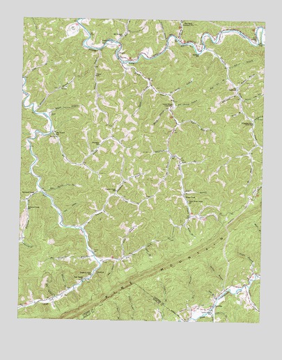
Roxana, KY USGS Topographic Map
Click on map above to begin viewing in our Map Viewer.

This topographic map contains these locations and features:
Feature Name Type Latitude Longitude GNIS ID View Map
Abner BranchStreamN37.0404°W82.9143°485730View Map
Alice Post Office (historical)Post OfficeN37.1138°W82.9070°2336237View Map
Andy BranchStreamN37.0095°W82.8971°485952View Map
Barking SchoolSchoolN37.1112°W82.9082°486352View Map
Barlow BranchStreamN37.0126°W82.8929°486361View Map
Big Bottom BranchStreamN37.0895°W82.9199°487086View Map
Big BranchStreamN37.0095°W82.9807°487092View Map
Big BranchStreamN37.0781°W82.9841°487093View Map
Big Branch SchoolSchoolN37.0768°W82.9818°487143View Map
Big Eli BranchStreamN37.1012°W82.8929°487168View Map
Big HollowValleyN37.0247°W82.9493°487186View Map
Bill Harris BranchStreamN37.0518°W82.9863°487302View Map
Blackey DivisionCivilN37.0840°W82.9796°1936877View Map
Bo ForkStreamN37.0737°W82.8779°487571View Map
Camp BranchStreamN37.0262°W82.9452°488667View Map
Cape Post Office (historical)Post OfficeN37.0775°W82.9221°2336263View Map
Carrion BranchStreamN37.0709°W82.9235°488978View Map
Chestnut Hill Post Office (historical)Post OfficeN37.0859°W82.9930°2336268View Map
Coal BranchStreamN37.0034°W82.8991°489720View Map
Colliers CreekStreamN37.0148°W82.8807°485675View Map
Connetts Post Office (historical)Post OfficeN37.0268°W82.9608°2336274View Map
Cornetts BranchStreamN37.0268°W82.9610°490124View Map
Cornetts CemeteryCemeteryN37.0287°W82.9613°490125View Map
Cottonpatch BranchStreamN37.0840°W82.8802°490149View Map
Day SchoolSchoolN37.0684°W82.9199°490704View Map
Day-Long BranchStreamN37.0705°W82.8814°2119696View Map
Deadening BranchStreamN37.0331°W82.9982°490724View Map
Defeated CreekPopulated PlaceN37.0518°W82.9929°490785View Map
Defeated CreekStreamN37.0531°W82.9888°511776View Map
Defeated Creek Post Office (historical)Post OfficeN37.0526°W82.9873°2336290View Map
Defeated Creek SchoolSchoolN37.0456°W82.9966°490787View Map
Dry ForkStreamN37.0243°W82.9579°491183View Map
Dry ForkStreamN37.1209°W82.8763°491202View Map
Elkins BranchStreamN37.0198°W82.8777°491694View Map
Extra Post Office (historical)Post OfficeN37.1225°W82.9712°2336304View Map
Field Post Office (historical)Post OfficeN37.1190°W82.8763°2336306View Map
FlintPopulated PlaceN37.0509°W82.9335°508013View Map
Flint Post Office (historical)Post OfficeN37.0510°W82.9335°2336310View Map
Flintfield BranchStreamN37.0526°W82.9504°492254View Map
Four Square ChurchChurchN37.0165°W82.9671°492380View Map
Frazier BranchStreamN37.0976°W82.8890°492477View Map
Fugate BranchStreamN37.0537°W82.9154°492595View Map
Gate City Police DepartmentBuildingN37.0769°W82.9739°2085984View Map
Holcomb BranchStreamN37.0118°W82.9735°494379View Map
Hot Spot Premium Post OfficePost OfficeN37.1226°W82.9174°494625View Map
Hubert (historical)Populated PlaceN37.0528°W82.9880°2336125View Map
Ike BranchStreamN37.0693°W82.9216°494881View Map
Ingram CreekStreamN37.0384°W82.9679°494991View Map
Ingram Creek SchoolSchoolN37.0537°W82.9499°494992View Map
Island BranchStreamN37.0856°W82.9885°495041View Map
Isom CemeteryCemeteryN37.1209°W82.9729°495052View Map
King Creek Post Office (historical)Post OfficeN37.0402°W82.9158°2336137View Map
Kingdom Come (historical)Populated PlaceN37.0804°W82.8803°2336138View Map
Kingdom Come CreekStreamN37.1137°W82.9060°495750View Map
Kingdom Come Creek SchoolSchoolN37.0823°W82.8799°495751View Map
Kingdom Come SchoolSchoolN37.0190°W82.9621°495752View Map
Kings CreekStreamN37.1073°W82.9479°495760View Map
Kings CreekPopulated PlaceN37.0518°W82.9146°508391View Map
Kings Creek Volunteer Fire DepartmentBuildingN37.0872°W82.9231°2637239View Map
Laurel BranchStreamN37.0306°W82.9352°496009View Map
Lewis CreekStreamN37.0043°W82.9013°496325View Map
Lewis Creek Post Office (historical)Post OfficeN37.0045°W82.9010°2336144View Map
Lewis Creek SchoolSchoolN37.0037°W82.8996°496328View Map
Lick BranchStreamN37.0657°W82.9171°496402View Map
Lilley Cornett WoodsParkN37.0823°W82.9932°2336146View Map
Line Fork (historical)Populated PlaceN37.0201°W82.9602°2336148View Map
Line Fork Post OfficePost OfficeN37.0199°W82.9500°2336149View Map
LineforkPopulated PlaceN37.0198°W82.9596°508466View Map
Linzy HollowValleyN37.0442°W82.9782°496594View Map
Looney BranchStreamN37.0498°W82.9961°2119698View Map
Lower Kings Creek SchoolSchoolN37.0893°W82.9216°497289View Map
Lucky BranchStreamN37.0940°W82.9229°497333View Map
Lynn BranchStreamN37.0818°W82.9188°497372View Map
Maggard Post Office (historical)Post OfficeN37.0155°W82.8829°2336155View Map
Mill BranchStreamN37.1157°W82.9507°498224View Map
Mill Branch SchoolSchoolN37.1182°W82.9479°498231View Map
Morgan CemeteryCemeteryN37.0848°W82.9849°498586View Map
Muddy BranchStreamN37.0879°W82.9224°499023View Map
Ned BranchStreamN37.1059°W82.8935°499211View Map
Oldhouse BranchStreamN37.1165°W82.9246°499905View Map
OscaloosaPopulated PlaceN37.0970°W82.8885°508761View Map
Pacies BranchStreamN37.0979°W82.9329°500094View Map
Partride Post OfficePost OfficeN37.0063°W82.8979°2336172View Map
PartridgePopulated PlaceN37.0065°W82.8979°508781View Map
Poplar Log HollowValleyN37.0923°W82.8866°501125View Map
RoxanaPopulated PlaceN37.1112°W82.9499°502435View Map
School Number Nine (historical)SchoolN37.0859°W82.9215°2336195View Map
SkylinePopulated PlaceN37.0759°W82.9816°509072View Map
Skyline Post Office (historical)Post OfficeN37.0756°W82.9817°2336205View Map
Smoot CreekStreamN37.1170°W82.9188°503826View Map
Smoot Creek Railroad Station (historical)LocaleN37.1173°W82.9194°2336208View Map
Sparkman BranchStreamN37.0609°W82.9944°2119697View Map
Spicewood BranchStreamN37.0954°W82.8882°504067View Map
Spring BranchStreamN37.0873°W82.8857°504100View Map
Tolby BranchStreamN37.1001°W82.9988°505318View Map
Tolson BranchStreamN37.1126°W82.9602°505328View Map
Tolson Branch ChurchChurchN37.1157°W82.9527°505329View Map
Tolson SchoolSchoolN37.1015°W82.9618°505330View Map
Upper Kings Creek SchoolSchoolN37.0498°W82.9129°505888View Map
UZ Post Office (historical)Post OfficeN37.1192°W82.8852°2336227View Map
UZ Railroad Station (historical)LocaleN37.1197°W82.8858°2336228View Map
Uz SchoolSchoolN37.1182°W82.8796°505932View Map
Whitaker BranchStreamN37.0859°W82.9932°506566View Map
Whitaker SchoolSchoolN37.0729°W82.9591°506569View Map
Win BranchStreamN37.0018°W82.9099°506922View Map

Note: Coordinates in the location and feature list above are referenced to NAD83 datum.


Copyright (C) 2008-2024 Ryan Niemi / Sunset Dynamics ... All Rights Reserved