TopoQuest Logo
Do you find TopoQuest useful?
Help keep TopoQuest running and adding new maps/features by donating!
Bitcoin:  19c7KJd3qBynnjoSw5npx9KScwjBe4ifkT
Litecoin:  LXs6TkuXGGXo1vDsWCkWVdjQX94eUKd6ui
Home View Maps Find Maps Find Places Resources & Links


Rudolph Hill, Colorado Topographic Map

USGS Map Title: Rudolph Hill, CO
USGS Map MRC: 38107B1
DRG (GeoTIFF) Download: o38107b1.tif


Neighboring USGS Topographic Map Quads:


  Gateview, CO  
38107C2
 

  Powderhorn, CO  
38107C1
 

  Spring Hill Creek, CO  
38106C8
 

  Powderhorn Lakes, CO  
38107B2
 

  Rudolph Hill, CO  
38107B1
 

  Rock Creek Park, CO  
38106B8
 

  Cannibal Plateau, CO  
38107A2
 

  Mineral Mountain, CO  
38107A1
 

  Stewart Peak, CO  
38106A8


Map MRC Location:

N39°
W108°
N39°
W107°
H8 H7 H6 H5 H4 H3 H2 H1
G8 G7 G6 G5 G4 G3 G2 G1
F8 F7 F6 F5 F4 F3 F2 F1
E8 E7 E6 E5 E4 E3 E2 E1
D8 D7 D6 D5 D4 D3 D2 D1
C8 C7 C6 C5 C4 C3 C2 C1
B8 B7 B6 B5 B4 B3 B2 B1
A8 A7 A6 A5 A4 A3 A2 A1
N38°
W108°
N38°
W107°

Rudolph Hill, CO USGS 1:24K Topographic Map Preview:
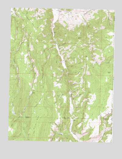
Rudolph Hill, CO USGS Topographic Map
Click on map above to begin viewing in our Map Viewer.

This topographic map contains these locations and features:
Feature Name Type Latitude Longitude GNIS ID View Map
Alexite MineMineN38.2378°W107.0664°1745602View Map
Bar GulchValleyN38.1506°W107.0490°188517View Map
Bear GulchValleyN38.1326°W107.0610°188518View Map
Bowers LakesReservoirN38.1326°W107.0624°201699View Map
Bowers Lakes DamDamN38.1317°W107.0623°201698View Map
Burnt CreekStreamN38.1328°W107.1056°188508View Map
Crystal CreekStreamN38.1708°W107.0523°188521View Map
Dempsey ParksFlatN38.1610°W107.0891°188544View Map
Devils HoleValleyN38.1358°W107.0089°188512View Map
Dry GulchValleyN38.1715°W107.0519°188524View Map
East Dempsey GulchValleyN38.2147°W107.0683°188539View Map
East Fork Powderhorn CreekStreamN38.2244°W107.1081°188513View Map
Fish CanyonValleyN38.1331°W107.0497°188514View Map
Hidden LakeReservoirN38.1655°W107.0495°188520View Map
Horse ParkFlatN38.2189°W107.0831°188537View Map
House GulchValleyN38.1575°W107.0480°188522View Map
Jardine RanchLocaleN38.2272°W107.0739°188536View Map
Johnson GulchValleyN38.2076°W107.0664°188531View Map
Johnson ParkFlatN38.2072°W107.0733°188530View Map
Kelso GulchValleyN38.2274°W107.0747°188540View Map
Middle Fork Powderhorn CreekStreamN38.2244°W107.1081°188506View Map
Miller HillSummitN38.2058°W107.0348°188527View Map
Mud GulchValleyN38.1944°W107.0566°188529View Map
North Beaver CreekStreamN38.2442°W107.0398°188345View Map
Park CreekStreamN38.1358°W107.0087°188516View Map
Phelps Cabin CreekStreamN38.1489°W107.1053°188507View Map
Polepatch HillSummitN38.1908°W107.0062°188528View Map
Powderhorn CemeteryCemeteryN38.2453°W107.0645°188538View Map
Road Beaver CreekStreamN38.2489°W107.0714°188541View Map
Rudolph GulchValleyN38.1945°W107.0588°188533View Map
Rudolph HillSummitN38.2231°W107.0442°188534View Map
Sammons RanchLocaleN38.2478°W107.0673°188535View Map
Smith PlacePopulated PlaceN38.2017°W107.0598°188532View Map
Swinehart GulchValleyN38.1762°W107.0523°188525View Map
Swinehart RidgeRidgeN38.1953°W107.0389°188526View Map
Tenmile SpringsSpringN38.1706°W107.0973°188543View Map
Vermiculite Mining Company MineMineN38.2381°W107.0459°1745603View Map
Water GulchValleyN38.1649°W107.0503°188523View Map
West Dempsey GulchValleyN38.2136°W107.0690°188542View Map
West Fork Powderhorn CreekStreamN38.2450°W107.1209°188505View Map
Youmans RanchLocaleN38.1453°W107.0481°188519View Map

Note: Coordinates in the location and feature list above are referenced to NAD83 datum.


Copyright (C) 2008-2024 Ryan Niemi / Sunset Dynamics ... All Rights Reserved