TopoQuest Logo
Do you find TopoQuest useful?
Help keep TopoQuest running and adding new maps/features by donating!
Bitcoin:  19c7KJd3qBynnjoSw5npx9KScwjBe4ifkT
Litecoin:  LXs6TkuXGGXo1vDsWCkWVdjQX94eUKd6ui
Home View Maps Find Maps Find Places Resources & Links


Rudyard, Michigan Topographic Map

USGS Map Title: Rudyard, MI
USGS Map MRC: 46084B5
DRG (GeoTIFF) Download: o46084b5.tif


Neighboring USGS Topographic Map Quads:


  Raco, MI  
46084C6
 

  Kinross, MI  
46084C5
 

  Dafter, MI  
46084C4
 

  Fibre, MI  
46084B6
 

  Rudyard, MI  
46084B5
 

  Pickford NW, MI  
46084B4
 

  Charles, MI  
46084A6
 

  Pontchartrain Shores, MI  
46084A5
 

  Hessel, MI  
46084A4


Map MRC Location:

N47°
W85°
N47°
W84°
H8 H7 H6 H5 H4 H3 H2 H1
G8 G7 G6 G5 G4 G3 G2 G1
F8 F7 F6 F5 F4 F3 F2 F1
E8 E7 E6 E5 E4 E3 E2 E1
D8 D7 D6 D5 D4 D3 D2 D1
C8 C7 C6 C5 C4 C3 C2 C1
B8 B7 B6 B5 B4 B3 B2 B1
A8 A7 A6 A5 A4 A3 A2 A1
N46°
W85°
N46°
W84°

Rudyard, MI USGS 1:24K Topographic Map Preview:
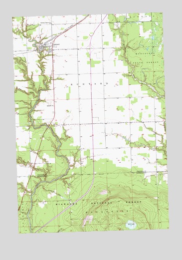
Rudyard, MI USGS Topographic Map
Click on map above to begin viewing in our Map Viewer.

This topographic map contains these locations and features:
Feature Name Type Latitude Longitude GNIS ID View Map
Apostolic ChurchChurchN46.1981°W84.5931°1619034View Map
Bear CreekStreamN46.2036°W84.6053°1619125View Map
Christian Reform ChurchChurchN46.2459°W84.5928°1622517View Map
Chub CreekStreamN46.1547°W84.6023°1619506View Map
Hiawatha RunStreamN46.1511°W84.6098°1620189View Map
Hill LakeLakeN46.1281°W84.5319°1620208View Map
North Pine RiverStreamN46.2056°W84.6048°1621054View Map
Presbyterian ChurchChurchN46.2331°W84.5936°2356271View Map
RudyardPopulated PlaceN46.2325°W84.6003°1621457View Map
Rudyard Bible ChurchChurchN46.2328°W84.5939°2356270View Map
Rudyard High SchoolSchoolN46.2292°W84.5969°2356277View Map
Rudyard Post OfficePost OfficeN46.2303°W84.5930°2356273View Map
Rudyard Public LibraryBuildingN46.2292°W84.5969°2356278View Map
Rudyard StationLocaleN46.2328°W84.6011°2356274View Map
Rudyard Township ParkParkN46.2356°W84.5897°2356275View Map
Rudyard Township Volunteer Fire DepartmentBuildingN46.2330°W84.5919°2626958View Map
Saint James Lutheran ChurchChurchN46.2289°W84.5947°2356269View Map
Saint Joseph Roman Catholic ChurchChurchN46.2306°W84.6094°2356272View Map
Saint Rudyard CemeteryCemeteryN46.1864°W84.5931°1621492View Map
South Rudyard CemeteryCemeteryN46.1867°W84.5931°2356425View Map
Township of RudyardCivilN46.2131°W84.6198°1627015View Map
Turner Howson Elementary SchoolSchoolN46.2261°W84.5961°2356276View Map

Note: Coordinates in the location and feature list above are referenced to NAD83 datum.


Copyright (C) 2008-2025 Ryan Niemi / Sunset Dynamics ... All Rights Reserved