TopoQuest Logo
Do you find TopoQuest useful?
Help keep TopoQuest running and adding new maps/features by donating!
Bitcoin:  19c7KJd3qBynnjoSw5npx9KScwjBe4ifkT
Litecoin:  LXs6TkuXGGXo1vDsWCkWVdjQX94eUKd6ui
Home View Maps Find Maps Find Places Resources & Links


Russellville, North Carolina Topographic Map

USGS Map Title: Russellville, NC
USGS Map MRC: 34080H2
DRG (GeoTIFF) Download: o34080h2.tif


Neighboring USGS Topographic Map Quads:


  Olive Branch, NC  
35080A3
 

  Polkton, NC  
35080A2
 

  Ansonville, NC  
35080A1
 

  Marshville, NC  
34080H3
 

  Russellville, NC  
34080H2
 

  Wadesboro, NC  
34080H1
 

  Hornsboro, SC  
34080G3
 

  Mount Croghan, SC  
34080G2
 

  Morven West, NC  
34080G1


Map MRC Location:

N35°
W81°
N35°
W80°
H8 H7 H6 H5 H4 H3 H2 H1
G8 G7 G6 G5 G4 G3 G2 G1
F8 F7 F6 F5 F4 F3 F2 F1
E8 E7 E6 E5 E4 E3 E2 E1
D8 D7 D6 D5 D4 D3 D2 D1
C8 C7 C6 C5 C4 C3 C2 C1
B8 B7 B6 B5 B4 B3 B2 B1
A8 A7 A6 A5 A4 A3 A2 A1
N34°
W81°
N34°
W80°

Russellville, NC USGS 1:24K Topographic Map Preview:
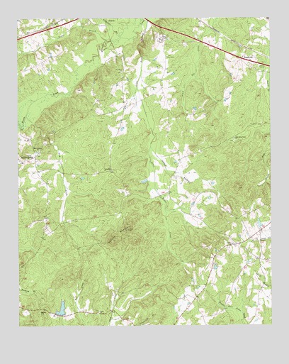
Russellville, NC USGS Topographic Map
Click on map above to begin viewing in our Map Viewer.

This topographic map contains these locations and features:
Feature Name Type Latitude Longitude GNIS ID View Map
Becky HillSummitN34.8810°W80.2395°1019039View Map
Brown Creek Correctional InstitutionBuildingN34.9861°W80.1800°2769828View Map
Camden ChurchChurchN34.9085°W80.1440°982473View Map
Camden Church CemeteryCemeteryN34.9084°W80.1437°2778988View Map
Frank Little PondReservoirN34.9166°W80.1304°998204View Map
Frank Little Pond DamDamN34.9152°W80.1298°998205View Map
Gaddys PondReservoirN34.8990°W80.1525°998196View Map
Gaddys Pond DamDamN34.8985°W80.1515°998197View Map
Gordon MountainSummitN34.9099°W80.2034°985834View Map
Kelly BranchStreamN34.9571°W80.2498°987902View Map
Lanesboro Correctional InstitutionBuildingN34.9856°W80.1837°2769829View Map
Ledbetter BranchStreamN34.9940°W80.1978°988277View Map
Leggett BranchStreamN34.9479°W80.1845°988330View Map
Lick CreekStreamN34.9610°W80.2453°988446View Map
Mineral SpringsPopulated PlaceN34.9440°W80.2412°1021488View Map
Mineral Springs Baptist Church CemeteryCemeteryN34.9443°W80.2405°2778995View Map
Mineral Springs ChurchChurchN34.9471°W80.2390°990048View Map
New Grove ChurchChurchN34.9785°W80.1981°990968View Map
Poplar Hill (historical)Populated PlaceN34.9463°W80.2026°1002144View Map
Poplar Hill ChurchChurchN34.9385°W80.2040°992694View Map
RussellvillePopulated PlaceN34.9835°W80.1384°1022447View Map
Swans BranchStreamN34.9910°W80.2059°995765View Map
Township of LanesboroCivilN34.9917°W80.2352°1026374View Map
TravisPopulated PlaceN34.9110°W80.1353°1023479View Map
Union ChurchChurchN34.8810°W80.2101°996447View Map
Unity ChapelChurchN34.9846°W80.1765°996525View Map
West Rocky Ford ChurchChurchN34.9515°W80.1426°997043View Map
White Store DamDamN34.8968°W80.2298°998191View Map
White Store LakeReservoirN34.8968°W80.2298°998192View Map

Note: Coordinates in the location and feature list above are referenced to NAD83 datum.


Copyright (C) 2008-2024 Ryan Niemi / Sunset Dynamics ... All Rights Reserved