TopoQuest Logo
Do you find TopoQuest useful?
Help keep TopoQuest running and adding new maps/features by donating!
Bitcoin:  19c7KJd3qBynnjoSw5npx9KScwjBe4ifkT
Litecoin:  LXs6TkuXGGXo1vDsWCkWVdjQX94eUKd6ui
Home View Maps Find Maps Find Places Resources & Links


Saddle Mountain, Oklahoma Topographic Map

USGS Map Title: Saddle Mountain, OK
USGS Map MRC: 34098G6
DRG (GeoTIFF) Download: o34098g6.tif


Neighboring USGS Topographic Map Quads:


  Unap Mountain, OK  
34098H7
 

  Bally Mountain, OK  
34098H6
 

  Alden, OK  
34098H5
 

  Cooperton, OK  
34098G7
 

  Saddle Mountain, OK  
34098G6
 

  Meers, OK  
34098G5
 

  Odetta, OK  
34098F7
 

  Quanah Mountain, OK  
34098F6
 

  Mount Scott, OK  
34098F5


Map MRC Location:

N35°
W99°
N35°
W98°
H8 H7 H6 H5 H4 H3 H2 H1
G8 G7 G6 G5 G4 G3 G2 G1
F8 F7 F6 F5 F4 F3 F2 F1
E8 E7 E6 E5 E4 E3 E2 E1
D8 D7 D6 D5 D4 D3 D2 D1
C8 C7 C6 C5 C4 C3 C2 C1
B8 B7 B6 B5 B4 B3 B2 B1
A8 A7 A6 A5 A4 A3 A2 A1
N34°
W99°
N34°
W98°

Saddle Mountain, OK USGS 1:24K Topographic Map Preview:
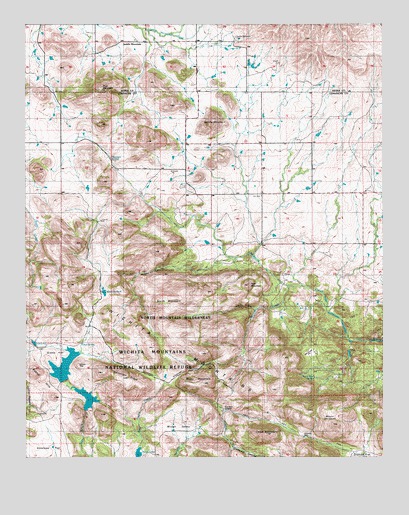
Saddle Mountain, OK USGS Topographic Map
Click on map above to begin viewing in our Map Viewer.

This topographic map contains these locations and features:
Feature Name Type Latitude Longitude GNIS ID View Map
Antelope FlatFlatN34.7556°W98.7437°1101039View Map
Antelope FlatFlatN34.7509°W98.7459°1089641View Map
Black Bear SpringSpringN34.7731°W98.6501°1101152View Map
Blue MountainSummitN34.8559°W98.7234°1090286View Map
Cedar MountainSummitN34.7570°W98.6662°1091128View Map
Cold SpringSpringN34.7831°W98.7145°1101147View Map
Comanche LakeReservoirN34.7673°W98.7288°1091590View Map
Comanche Lake DamDamN34.7634°W98.7303°1751776View Map
Elk PassGapN34.7651°W98.7217°1092537View Map
Geronimo RidgeRidgeN34.7751°W98.7167°1093170View Map
Grama FlatFlatN34.7820°W98.7384°1093296View Map
Grama LakeReservoirN34.7765°W98.7370°1751093View Map
Gramma Lake DamDamN34.7717°W98.7387°1751092View Map
Gray Wolf CrossingCrossingN34.7642°W98.6798°1777890View Map
Gray Wolf SpringSpringN34.7648°W98.6817°1101148View Map
Greenleaf CanyonValleyN34.7528°W98.6782°1093386View Map
Harrington SpringSpringN34.8367°W98.7209°1101145View Map
Hobbs CanyonValleyN34.8078°W98.6780°1093808View Map
Hollis PondReservoirN34.7832°W98.7474°1093849View Map
Hourigan SpringSpringN34.8365°W98.7206°1777891View Map
Kiowa LakeReservoirN34.7514°W98.7110°1094408View Map
Kiowa Lake DamDamN34.7501°W98.7053°1751094View Map
Medicine TankReservoirN34.7976°W98.7228°1095294View Map
Moko MountainSummitN34.7715°W98.6951°1095470View Map
Moose CanyonValleyN34.7934°W98.6706°1095502View Map
Mount LauramacSummitN34.7595°W98.6428°1094513View Map
North MountainSummitN34.7962°W98.6992°1095983View Map
North Mountain WildernessReserveN34.7896°W98.6956°1101149View Map
Oknoname 123006 DamDamN34.8267°W98.6303°1753461View Map
Oknoname 123006 ReservoirReservoirN34.8267°W98.6303°1753462View Map
Pearl MountainSummitN34.8001°W98.6723°1096505View Map
Rain Gauge FlatFlatN34.7801°W98.6520°1101150View Map
Saddle MountainLocaleN34.8698°W98.7073°1097566View Map
Saddle MountainSummitN34.8465°W98.6840°1097567View Map
Saddle Mountain CemeteryCemeteryN34.8712°W98.6768°1101146View Map
Saddle Mountain Fire DepartmentBuildingN34.8486°W98.6895°2658551View Map
Saddle Mountain Indian Mission (historical)ChurchN34.8723°W98.6798°1101232View Map
Soldiers DamDamN34.7565°W98.6537°1101151View Map
Spencer CreekStreamN34.7995°W98.6584°1098351View Map
Township of Saddle MountainCivilN34.8292°W98.6753°1825346View Map
Turkey PassGapN34.7698°W98.6967°1099060View Map
Whistle PeakSummitN34.7767°W98.7326°1099687View Map
Wichita MountainsRangeN34.7595°W98.6434°1101242View Map
Wichita Mountains Wilderness (North Mountain Unit)ReserveN34.7892°W98.6951°2035340View Map
Wichita Mountains Wildlife RefugeParkN34.7520°W98.6874°1100110View Map
Winter ValleyValleyN34.7539°W98.6967°1099923View Map

Note: Coordinates in the location and feature list above are referenced to NAD83 datum.


Copyright (C) 2008-2024 Ryan Niemi / Sunset Dynamics ... All Rights Reserved