TopoQuest Logo
Do you find TopoQuest useful?
Help keep TopoQuest running and adding new maps/features by donating!
Bitcoin:  19c7KJd3qBynnjoSw5npx9KScwjBe4ifkT
Litecoin:  LXs6TkuXGGXo1vDsWCkWVdjQX94eUKd6ui
Home View Maps Find Maps Find Places Resources & Links


Saint George SW, South Carolina Topographic Map

USGS Map Title: Saint George SW, SC
USGS Map MRC: 33080A6
DRG (GeoTIFF) Download: o33080a6.tif


Neighboring USGS Topographic Map Quads:


  Branchville South, SC  
33080B7
 

  Reevesville, SC  
33080B6
 

  Saint George, SC  
33080B5
 

  Williams, SC  
33080A7
 

  Saint George SW, SC  
33080A6
 

  Canadys, SC  
33080A5
 

  Sniders Crossroads, SC  
32080H7
 

  Walterboro, SC  
32080H6
 

  Round O, SC  
32080H5


Map MRC Location:

N34°
W81°
N34°
W80°
H8 H7 H6 H5 H4 H3 H2 H1
G8 G7 G6 G5 G4 G3 G2 G1
F8 F7 F6 F5 F4 F3 F2 F1
E8 E7 E6 E5 E4 E3 E2 E1
D8 D7 D6 D5 D4 D3 D2 D1
C8 C7 C6 C5 C4 C3 C2 C1
B8 B7 B6 B5 B4 B3 B2 B1
A8 A7 A6 A5 A4 A3 A2 A1
N33°
W81°
N33°
W80°

Saint George SW, SC USGS 1:24K Topographic Map Preview:
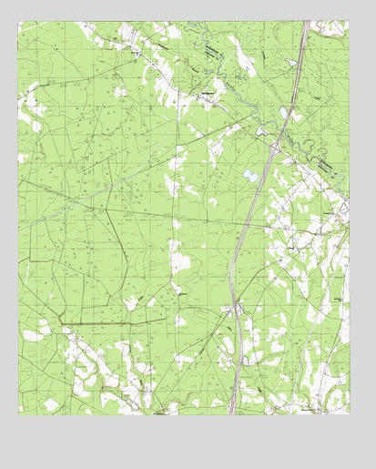
Saint George SW, SC USGS Topographic Map
Click on map above to begin viewing in our Map Viewer.

This topographic map contains these locations and features:
Feature Name Type Latitude Longitude GNIS ID View Map
Brickhouse BranchStreamN33.1085°W80.6745°1240569View Map
Canaan ChurchChurchN33.0641°W80.6312°1240575View Map
Cokers PondReservoirN33.0035°W80.7015°1239394View Map
Cokers Pond Dam D-0649DamN33.0035°W80.7015°1239393View Map
Green PondLakeN33.1096°W80.6995°1240628View Map
Green Pond CemeteryCemeteryN33.1143°W80.7037°1240629View Map
Green Pond ChurchChurchN33.1143°W80.7018°1245830View Map
Interchange 62CrossingN33.0027°W80.6693°1228307View Map
Interchange 68CrossingN33.0843°W80.6526°1228308View Map
Linder SchoolSchoolN33.0199°W80.7190°1223942View Map
Mount Carmel ChurchChurchN33.0007°W80.6943°1249557View Map
Mount Carmel School (historical)SchoolN33.0004°W80.6943°1240681View Map
Mount Pleasant ChurchChurchN33.0382°W80.6890°1224776View Map
Mount Pleasant School (historical)SchoolN33.0385°W80.6895°1240684View Map
Oakman Branch School (historical)SchoolN33.0532°W80.6457°1240692View Map
Oakman ChurchChurchN33.0541°W80.6470°1249933View Map
Pleasant Grove ChurchChurchN33.0016°W80.6376°1225532View Map
Pleasant Grove School (historical)SchoolN33.0007°W80.6373°1240710View Map
Raysor BridgeBridgeN33.1002°W80.6657°1225772View Map
Red Bank (historical)Populated PlaceN33.0302°W80.6276°1240713View Map
Red Bank ChurchChurchN33.0368°W80.6279°1240714View Map
Roadside School (historical)SchoolN33.0074°W80.6368°1240723View Map
South Carolina Noname 15033 D-2388 DamDamN33.1218°W80.7048°1238815View Map
Spell CemeteryCemeteryN33.1188°W80.7120°1240751View Map
SpringtownPopulated PlaceN33.0991°W80.6762°1240753View Map
Springtown ChurchChurchN33.1016°W80.6809°1240754View Map
Springtown Fire Department Station 17BuildingN33.1136°W80.7034°2368171View Map
Springtown SchoolSchoolN33.1013°W80.6812°1226849View Map
Stokes Lookout TowerTowerN33.0079°W80.7012°1240757View Map
WeeksPopulated PlaceN33.0468°W80.6265°1227460View Map

Note: Coordinates in the location and feature list above are referenced to NAD83 datum.


Copyright (C) 2008-2025 Ryan Niemi / Sunset Dynamics ... All Rights Reserved