TopoQuest Logo
Do you find TopoQuest useful?
Help keep TopoQuest running and adding new maps/features by donating!
Bitcoin:  19c7KJd3qBynnjoSw5npx9KScwjBe4ifkT
Litecoin:  LXs6TkuXGGXo1vDsWCkWVdjQX94eUKd6ui
Home View Maps Find Maps Find Places Resources & Links


Saint Libory, Illinois Topographic Map

USGS Map Title: Saint Libory, IL
USGS Map MRC: 38089C6
DRG (GeoTIFF) Download: o38089c6.tif


Neighboring USGS Topographic Map Quads:


  Mascoutah, IL  
38089D7
 

  Venedy, IL  
38089D6
 

  Okawville, IL  
38089D5
 

  New Athens East, IL  
38089C7
 

  Saint Libory, IL  
38089C6
 

  Oakdale, IL  
38089C5
 

  Baldwin, IL  
38089B7
 

  Tilden, IL  
38089B6
 

  Coulterville, IL  
38089B5


Map MRC Location:

N39°
W90°
N39°
W89°
H8 H7 H6 H5 H4 H3 H2 H1
G8 G7 G6 G5 G4 G3 G2 G1
F8 F7 F6 F5 F4 F3 F2 F1
E8 E7 E6 E5 E4 E3 E2 E1
D8 D7 D6 D5 D4 D3 D2 D1
C8 C7 C6 C5 C4 C3 C2 C1
B8 B7 B6 B5 B4 B3 B2 B1
A8 A7 A6 A5 A4 A3 A2 A1
N38°
W90°
N38°
W89°

Saint Libory, IL USGS 1:24K Topographic Map Preview:
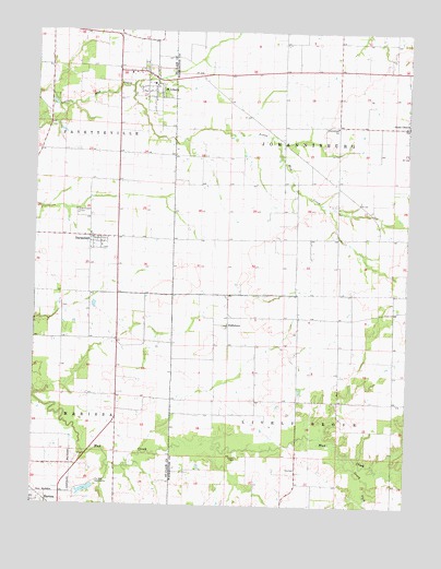
Saint Libory, IL USGS Topographic Map
Click on map above to begin viewing in our Map Viewer.

This topographic map contains these locations and features:
Feature Name Type Latitude Longitude GNIS ID View Map
BiddlebornPopulated PlaceN38.2978°W89.6848°422461View Map
CasparsPopulated PlaceN38.3000°W89.6618°1823757View Map
Caspars Post Office (historical)Post OfficeN38.3000°W89.6618°1823758View Map
DarmstadtPopulated PlaceN38.3209°W89.7318°426309View Map
Darmstadt Census Designated PlaceCensusN38.3190°W89.7288°2583437View Map
Darmstadt Memorial CemeteryCemeteryN38.3273°W89.7359°426310View Map
Johannisburg Grade SchoolSchoolN38.3500°W89.6493°411132View Map
Lively Grove TownhallBuildingN38.2598°W89.6618°1823783View Map
Marissa ReservoirReservoirN38.2540°W89.7319°1691412View Map
Marissa Reservoir DamDamN38.2550°W89.7301°1691411View Map
Marissa WaterworksLocaleN38.2562°W89.7282°426423View Map
Saint Damian CemeteryCemeteryN38.3406°W89.6254°1965772View Map
Saint LiboryPopulated PlaceN38.3625°W89.7098°426510View Map
Saint Libory Post OfficePost OfficeN38.3641°W89.7142°2788902View Map
Saint Libory Volunteer Fire DepartmentBuildingN38.3652°W89.7136°2640635View Map
Salem CemeteryCemeteryN38.2628°W89.6806°417856View Map
Shubert Airport (historical)AirportN38.2745°W89.6351°427469View Map
South Fork Mud CreekStreamN38.2637°W89.6451°418768View Map
Stone ChurchPopulated PlaceN38.3503°W89.6254°419162View Map
Stone Church Post Office (historical)Post OfficeN38.3500°W89.6259°1823806View Map
Township of JohannisburgCivilN38.3496°W89.6486°429185View Map
Township of Lively GroveCivilN38.2627°W89.6482°429268View Map
Village of Saint LiboryCivilN38.3636°W89.7135°2399167View Map

Note: Coordinates in the location and feature list above are referenced to NAD83 datum.


Copyright (C) 2008-2024 Ryan Niemi / Sunset Dynamics ... All Rights Reserved