TopoQuest Logo
Do you find TopoQuest useful?
Help keep TopoQuest running and adding new maps/features by donating!
Bitcoin:  19c7KJd3qBynnjoSw5npx9KScwjBe4ifkT
Litecoin:  LXs6TkuXGGXo1vDsWCkWVdjQX94eUKd6ui
Home View Maps Find Maps Find Places Resources & Links


San Rafael, New Mexico Topographic Map

USGS Map Title: San Rafael, NM
USGS Map MRC: 35107A8
DRG (GeoTIFF) Download: o35107a8.tif


Neighboring USGS Topographic Map Quads:


  Mount Sedgwick, NM  
35108B1
 

  Milan, NM  
35107B8
 

  Grants, NM  
35107B7
 

  Paxton Springs, NM  
35108A1
 

  San Rafael, NM  
35107A8
 

  Grants SE, NM  
35107A7
 

  Ice Caves, NM  
34108H1
 

  Arrosa Ranch, NM  
34107H8
 

  Los Pilares, NM  
34107H7


Map MRC Location:

N36°
W108°
N36°
W107°
H8 H7 H6 H5 H4 H3 H2 H1
G8 G7 G6 G5 G4 G3 G2 G1
F8 F7 F6 F5 F4 F3 F2 F1
E8 E7 E6 E5 E4 E3 E2 E1
D8 D7 D6 D5 D4 D3 D2 D1
C8 C7 C6 C5 C4 C3 C2 C1
B8 B7 B6 B5 B4 B3 B2 B1
A8 A7 A6 A5 A4 A3 A2 A1
N35°
W108°
N35°
W107°

San Rafael, NM USGS 1:24K Topographic Map Preview:
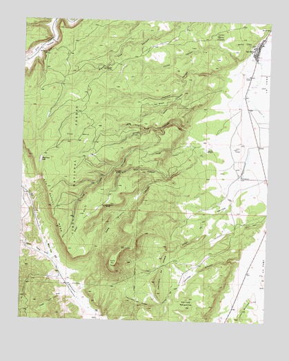
San Rafael, NM USGS Topographic Map
Click on map above to begin viewing in our Map Viewer.

This topographic map contains these locations and features:
Feature Name Type Latitude Longitude GNIS ID View Map
10021 Water WellWellN35.0198°W107.8770°922111View Map
10036 Water WellWellN35.1178°W107.8795°919620View Map
10037 Water WellWellN35.1220°W107.8759°919621View Map
10038 Water WellWellN35.1220°W107.8759°919622View Map
10039 Water WellWellN35.0812°W107.8753°919623View Map
10043 Water WellWellN35.0600°W107.8881°921352View Map
Agua Fria Trail CanyonValleyN35.0803°W107.9176°903010View Map
Arroyo de los CerritosValleyN35.0645°W107.8878°903301View Map
Atarque del DoterReservoirN35.0714°W107.9076°903456View Map
Boneekay MineMineN35.0012°W107.9995°916420View Map
Cerrito ColoradoSummitN35.1189°W107.9012°904914View Map
Cerritos MargaritasSummitN35.0059°W107.9159°904924View Map
Chute MesaRidgeN35.1106°W107.9892°905146View Map
CibolaMineN35.1000°W107.9339°916902View Map
Cooperation District MineMineN35.0853°W107.9939°939857View Map
Copper Hill District MineMineN35.0853°W107.9939°940119View Map
Deer HillSummitN35.0292°W107.9764°905695View Map
Fools Gold DrawValleyN35.0109°W107.9737°906324View Map
Franks CanyonValleyN35.0884°W107.9120°906377View Map
Frijol MorroAreaN35.0767°W107.9731°906405View Map
Gallo PeakSummitN35.0237°W107.9526°906463View Map
Hanosh MineMineN35.0853°W107.9939°940123View Map
Hondo CanyonValleyN35.1084°W107.8906°907057View Map
Irene Number Two MineMineN35.0195°W107.9839°916422View Map
Jose Ignacio CanyonValleyN35.0712°W107.9101°907445View Map
Jose Ignacio SpringSpringN35.0479°W107.9579°907446View Map
KLLT-FM (Grants)TowerN35.1195°W107.9028°938662View Map
KZNM-FM (Grants)TowerN35.1192°W107.9028°938661View Map
Log Cabin CanyonValleyN35.0800°W107.9298°908114View Map
Loma MontosaSummitN35.0050°W107.8870°908133View Map
Loma PeladaSummitN35.0723°W107.8912°908136View Map
Lost CanyonValleyN35.0789°W107.9384°908237View Map
Low Lease MineMineN35.0853°W107.9939°940124View Map
Manga CanyonValleyN35.0714°W107.9184°908384View Map
Mathew - Whiteside MineMineN35.0853°W107.9939°940118View Map
Mesa CortadaSummitN35.0737°W107.9339°908595View Map
Miable MineMineN35.0853°W107.9939°917875View Map
Montezuma District MineMineN35.0853°W107.9939°939937View Map
Morada CanyonValleyN35.1145°W107.8842°908896View Map
Ojitos Cuates DrawValleyN35.0264°W107.9856°909282View Map
Ojo del GalloSpringN35.1223°W107.8758°917993View Map
Ojo del GalloSpringN35.1223°W107.8756°909296View Map
Pink Rose CanyonValleyN35.0587°W107.9276°909704View Map
Pink Rose SpringSpringN35.0617°W107.9504°909705View Map
Porter CemeteryCemeteryN35.1020°W107.8859°909797View Map
Punta MesaSummitN35.0400°W107.8862°909900View Map
Punta MesaRidgeN35.0400°W107.8837°1987617View Map
San RafaelPopulated PlaceN35.1125°W107.8826°923685View Map
San Rafael Census Designated PlaceCensusN35.0878°W107.8894°2584213View Map
San Rafael Elementary SchoolSchoolN35.1128°W107.8826°925110View Map
San Rafael Historical MarkerParkN35.1125°W107.8826°932324View Map
San Rafael MesaSummitN35.0473°W107.9851°910708View Map
San Rafael ParishChurchN35.1125°W107.8826°920420View Map
San Rafael Post OfficePost OfficeN35.1080°W107.8828°937887View Map
San Rafael Volunteer Fire DepartmentBuildingN35.1086°W107.8837°2658113View Map
Sawmill CanyonValleyN35.1017°W107.8978°910836View Map
Section 15 ProspectMineN35.0195°W107.9839°916402View Map
Slide Water WellWellN35.0525°W107.9992°918558View Map
Snooter SpringSpringN35.1051°W107.9592°911171View Map
Valle de los CerritosValleyN35.0262°W107.8889°912031View Map
West Trail LakeLakeN35.0667°W107.9912°912269View Map

Note: Coordinates in the location and feature list above are referenced to NAD83 datum.


Copyright (C) 2008-2024 Ryan Niemi / Sunset Dynamics ... All Rights Reserved