TopoQuest Logo
Do you find TopoQuest useful?
Help keep TopoQuest running and adding new maps/features by donating!
Bitcoin:  19c7KJd3qBynnjoSw5npx9KScwjBe4ifkT
Litecoin:  LXs6TkuXGGXo1vDsWCkWVdjQX94eUKd6ui
Home View Maps Find Maps Find Places Resources & Links


Sanderson, Texas Topographic Map

USGS Map Title: Sanderson, TX
USGS Map MRC: 30102B4
DRG (GeoTIFF) Download: o30102b4.tif


Neighboring USGS Topographic Map Quads:


  Toms Canyon, TX  
30102C5
 

  Big Canyon Ranch SW, TX  
30102C4
 

  Big Canyon Ranch, TX  
30102C3
 

  Ninemile Ranch, TX  
30102B5
 

  Sanderson, TX  
30102B4
 

  Sanderson NE, TX  
30102B3
 

  Big Brindle Canyon, TX  
30102A5
 

  Hagler Canyon, TX  
30102A4
 

  Sanderson SE, TX  
30102A3


Map MRC Location:

N31°
W103°
N31°
W102°
H8 H7 H6 H5 H4 H3 H2 H1
G8 G7 G6 G5 G4 G3 G2 G1
F8 F7 F6 F5 F4 F3 F2 F1
E8 E7 E6 E5 E4 E3 E2 E1
D8 D7 D6 D5 D4 D3 D2 D1
C8 C7 C6 C5 C4 C3 C2 C1
B8 B7 B6 B5 B4 B3 B2 B1
A8 A7 A6 A5 A4 A3 A2 A1
N30°
W103°
N30°
W102°

Sanderson, TX USGS 1:24K Topographic Map Preview:
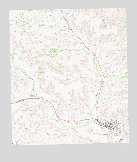
Sanderson, TX USGS Topographic Map
Click on map above to begin viewing in our Map Viewer.

This topographic map contains these locations and features:
Feature Name Type Latitude Longitude GNIS ID View Map
Cedar Grove CemeteryCemeteryN30.1319°W102.3863°1332428View Map
Deaf Smith County LibraryBuildingN30.1705°W102.3993°2015014View Map
Deaton RanchLocaleN30.1460°W102.4435°1334167View Map
Downie RanchLocaleN30.2316°W102.4396°1334587View Map
Goldwire RanchLocaleN30.2155°W102.4165°1336659View Map
Red Windmill DrawValleyN30.1717°W102.4794°1344969View Map
SandersonPopulated PlaceN30.1424°W102.3940°1346563View Map
Sanderson Census Designated PlaceCensusN30.1508°W102.4079°2409269View Map
Sanderson Post OfficePost OfficeN30.1407°W102.3996°2731880View Map
Santa Rita CemeteryCemeteryN30.1332°W102.3871°1346666View Map
Soil Conservation Service Site 10 DamDamN30.1869°W102.3971°1863829View Map
Soil Conservation Service Site 10 ReservoirReservoirN30.1864°W102.3961°1863830View Map
Soil Conservation Service Site 7 DamDamN30.2302°W102.4421°1863805View Map
Soil Conservation Service Site 7 ReservoirReservoirN30.2302°W102.4421°1863806View Map
Soil Conservation Service Site 8 DamDamN30.2119°W102.4254°1863242View Map
Soil Conservation Service Site 8 ReservoirReservoirN30.2130°W102.4275°1863243View Map
Soil Conservation Service Site 9 DamDamN30.1719°W102.4138°1863561View Map
Soil Conservation Service Site 9 ReservoirReservoirN30.1723°W102.4151°1863562View Map
Terrell County Emergency Medical ServiceBuildingN30.1410°W102.3965°2655757View Map
Terrell County Sheriff's OfficeBuildingN30.1434°W102.3947°2750527View Map
Terrell County Volunteer Fire DepartmentBuildingN30.1408°W102.3965°2552074View Map
Threemile DrawValleyN30.1471°W102.4145°1348533View Map
United States Border Patrol StationBuildingN30.1489°W102.4230°2750838View Map

Note: Coordinates in the location and feature list above are referenced to NAD83 datum.


Copyright (C) 2008-2025 Ryan Niemi / Sunset Dynamics ... All Rights Reserved