TopoQuest Logo
Do you find TopoQuest useful?
Help keep TopoQuest running and adding new maps/features by donating!
Bitcoin:  19c7KJd3qBynnjoSw5npx9KScwjBe4ifkT
Litecoin:  LXs6TkuXGGXo1vDsWCkWVdjQX94eUKd6ui
Home View Maps Find Maps Find Places Resources & Links


Sanford, Texas Topographic Map

USGS Map Title: Sanford, TX
USGS Map MRC: 35101F5
DRG (GeoTIFF) Download: o35101f5.tif


Neighboring USGS Topographic Map Quads:


  Pollard Creek, TX  
35101G6
 

  Camp Creek, TX  
35101G5
 

  Stinnett, TX  
35101G4
 

  Evans Canyon, TX  
35101F6
 

  Sanford, TX  
35101F5
 

  Borger, TX  
35101F4
 

  Alibates Ranch, TX  
35101E6
 

  Deal, TX  
35101E5
 

  McBride, TX  
35101E4


Map MRC Location:

N36°
W102°
N36°
W101°
H8 H7 H6 H5 H4 H3 H2 H1
G8 G7 G6 G5 G4 G3 G2 G1
F8 F7 F6 F5 F4 F3 F2 F1
E8 E7 E6 E5 E4 E3 E2 E1
D8 D7 D6 D5 D4 D3 D2 D1
C8 C7 C6 C5 C4 C3 C2 C1
B8 B7 B6 B5 B4 B3 B2 B1
A8 A7 A6 A5 A4 A3 A2 A1
N35°
W102°
N35°
W101°

Sanford, TX USGS 1:24K Topographic Map Preview:
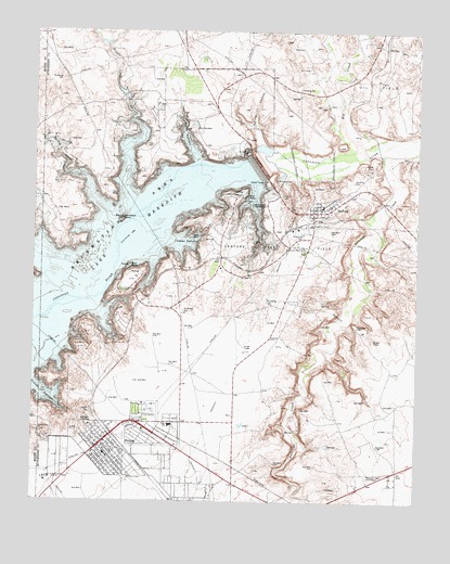
Sanford, TX USGS Topographic Map
Click on map above to begin viewing in our Map Viewer.

This topographic map contains these locations and features:
Feature Name Type Latitude Longitude GNIS ID View Map
Arrowhead IslandIslandN35.7003°W101.5966°1351276View Map
Big CreekStreamN35.7167°W101.5168°1372543View Map
Bugbee CanyonValleyN35.7056°W101.5954°2036409View Map
Bugbee CreekStreamN35.7064°W101.5954°1353218View Map
Camp CreekStreamN35.7300°W101.5254°1353631View Map
Cedar CanyonValleyN35.6939°W101.5810°1354043View Map
City of FritchCivilN35.6431°W101.5964°2410550View Map
FritchPopulated PlaceN35.6398°W101.6032°1357770View Map
Fritch City HallBuildingN35.6397°W101.6047°2753234View Map
Fritch Emergency Medical ServicesBuildingN35.6392°W101.6057°2656048View Map
Fritch Fortress Picnic AreaLocaleN35.6809°W101.5988°1357772View Map
Fritch Police DepartmentBuildingN35.6389°W101.6052°2750313View Map
Fritch Post OfficePost OfficeN35.6388°W101.6064°2731720View Map
Fritch Volunteer Fire DepartmentBuildingN35.6391°W101.6057°2551352View Map
Lake Meredith Aquatic and Wildlife MuseumBuildingN35.6392°W101.6043°2014619View Map
Lake Meredith Estates Census Designated PlaceCensusN35.6640°W101.6027°2586948View Map
North CanyonValleyN35.7155°W101.5721°1364013View Map
Oil CityPopulated PlaceN35.7470°W101.5135°1380290View Map
SanfordPopulated PlaceN35.7020°W101.5346°1367731View Map
Sanford - Fritch Elementary SchoolSchoolN35.6393°W101.6073°2006256View Map
Sanford CemeteryCemeteryN35.7102°W101.5215°1367732View Map
Sanford City HallBuildingN35.7037°W101.5333°2753745View Map
Sanford DamDamN35.7141°W101.5522°1367733View Map
Sanford Post OfficePost OfficeN35.7024°W101.5318°2731294View Map
Sanford Recreational AreaParkN35.7225°W101.5688°2029352View Map
Sanford Yake Oil FieldOilfieldN35.6898°W101.5488°1367735View Map
Spring CanyonValleyN35.7202°W101.5519°1368956View Map
Town of SanfordCivilN35.7026°W101.5318°2413257View Map
Turkey CreekStreamN35.7028°W101.6029°1370254View Map
Westlawn Memorial ParkCemeteryN35.6312°W101.5164°1384160View Map
Yake RanchLocaleN35.7456°W101.5382°1372001View Map

Note: Coordinates in the location and feature list above are referenced to NAD83 datum.


Copyright (C) 2008-2025 Ryan Niemi / Sunset Dynamics ... All Rights Reserved