TopoQuest Logo
Do you find TopoQuest useful?
Help keep TopoQuest running and adding new maps/features by donating!
Bitcoin:  19c7KJd3qBynnjoSw5npx9KScwjBe4ifkT
Litecoin:  LXs6TkuXGGXo1vDsWCkWVdjQX94eUKd6ui
Home View Maps Find Maps Find Places Resources & Links


Sapps Lake, Georgia Topographic Map

USGS Map Title: Sapps Lake, GA
USGS Map MRC: 31083C3
DRG (GeoTIFF) Download: o31083c3.tif


Neighboring USGS Topographic Map Quads:


  Tifton East, GA  
31083D4
 

  Enigma, GA  
31083D3
 

  Alapaha, GA  
31083D2
 

  Lenox, GA  
31083C4
 

  Sapps Lake, GA  
31083C3
 

  Tenmile Bay, GA  
31083C2
 

  Adel, GA  
31083B4
 

  Nashville West, GA  
31083B3
 

  Nashville East, GA  
31083B2


Map MRC Location:

N32°
W84°
N32°
W83°
H8 H7 H6 H5 H4 H3 H2 H1
G8 G7 G6 G5 G4 G3 G2 G1
F8 F7 F6 F5 F4 F3 F2 F1
E8 E7 E6 E5 E4 E3 E2 E1
D8 D7 D6 D5 D4 D3 D2 D1
C8 C7 C6 C5 C4 C3 C2 C1
B8 B7 B6 B5 B4 B3 B2 B1
A8 A7 A6 A5 A4 A3 A2 A1
N31°
W84°
N31°
W83°

Sapps Lake, GA USGS 1:24K Topographic Map Preview:
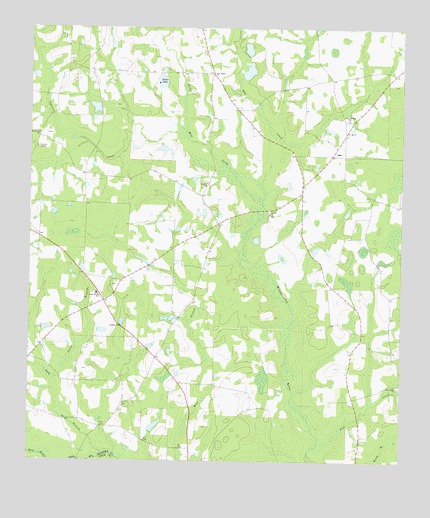
Sapps Lake, GA USGS Topographic Map
Click on map above to begin viewing in our Map Viewer.

This topographic map contains these locations and features:
Feature Name Type Latitude Longitude GNIS ID View Map
Cypress CreekStreamN31.3096°W83.3024°313239View Map
Ebenezer ChurchChurchN31.3444°W83.3721°313819View Map
Emmaus Primitive Baptist Church (historical)ChurchN31.2716°W83.2513°346064View Map
Enigma DivisionCivilN31.3657°W83.3473°1936252View Map
Flat CreekStreamN31.2555°W83.2771°314176View Map
Flat Creek CemeteryCemeteryN31.2719°W83.2504°346068View Map
Flat Creek ChurchChurchN31.2719°W83.2510°355822View Map
Gainey BridgeBridgeN31.2505°W83.3577°343886View Map
Gaskins LakeReservoirN31.2601°W83.3323°341946View Map
Gaskins Lake DamDamN31.2585°W83.3332°341945View Map
Gum BranchStreamN31.2521°W83.3479°314956View Map
Hardy Mill CreekStreamN31.3241°W83.2965°356173View Map
Hog CreekStreamN31.3241°W83.2965°315502View Map
Liberty ChurchChurchN31.3213°W83.2938°316800View Map
Lindsey LakeReservoirN31.3107°W83.2794°341944View Map
Lindsey Lake DamDamN31.3102°W83.2799°341943View Map
McMillian LakeReservoirN31.3628°W83.3016°342147View Map
McMillian LakeReservoirN31.3520°W83.3528°341942View Map
McMillian Lake DamDamN31.3602°W83.3032°342146View Map
McMillian Lake DamDamN31.3519°W83.3515°341941View Map
Parkers ChapelChurchN31.3405°W83.3727°320226View Map
Pine Ridge ChurchChurchN31.3616°W83.3124°320643View Map
Pleasant Hill ChurchChurchN31.3485°W83.2674°320869View Map
Poley BranchStreamN31.2746°W83.3663°320976View Map
Sapps LakeReservoirN31.3597°W83.3306°322520View Map
Sapps Lake DamDamN31.3599°W83.3293°340832View Map
Vickers CemeteryCemeteryN31.3307°W83.3163°346111View Map
Vickers ChurchChurchN31.3305°W83.3146°324692View Map
Vickers School (historical)SchoolN31.3302°W83.3157°346112View Map
West Berrien SchoolSchoolN31.2982°W83.3518°325037View Map
West Berrien Volunteer Fire DepartmentBuildingN31.3153°W83.3721°2604285View Map

Note: Coordinates in the location and feature list above are referenced to NAD83 datum.


Copyright (C) 2008-2024 Ryan Niemi / Sunset Dynamics ... All Rights Reserved