TopoQuest Logo
Do you find TopoQuest useful?
Help keep TopoQuest running and adding new maps/features by donating!
Bitcoin:  19c7KJd3qBynnjoSw5npx9KScwjBe4ifkT
Litecoin:  LXs6TkuXGGXo1vDsWCkWVdjQX94eUKd6ui
Home View Maps Find Maps Find Places Resources & Links


Satolah, Georgia Topographic Map

USGS Map Title: Satolah, GA
USGS Map MRC: 34083H2
DRG (GeoTIFF) Download: o34083h2.tif


Neighboring USGS Topographic Map Quads:


  Scaly Mountain, NC  
35083A3
 

  Highlands, NC  
35083A2
 

  Cashiers, NC  
35083A1
 

  Rabun Bald, GA  
34083H3
 

  Satolah, GA  
34083H2
 

  Tamassee, SC  
34083H1
 

  Rainy Mountain, GA  
34083G3
 

  Whetstone, SC  
34083G2
 

  Walhalla, SC  
34083G1


Map MRC Location:

N35°
W84°
N35°
W83°
H8 H7 H6 H5 H4 H3 H2 H1
G8 G7 G6 G5 G4 G3 G2 G1
F8 F7 F6 F5 F4 F3 F2 F1
E8 E7 E6 E5 E4 E3 E2 E1
D8 D7 D6 D5 D4 D3 D2 D1
C8 C7 C6 C5 C4 C3 C2 C1
B8 B7 B6 B5 B4 B3 B2 B1
A8 A7 A6 A5 A4 A3 A2 A1
N34°
W84°
N34°
W83°

Satolah, GA USGS 1:24K Topographic Map Preview:
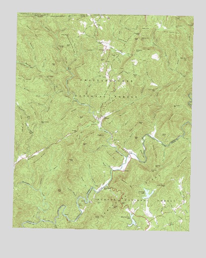
Satolah, GA USGS Topographic Map
Click on map above to begin viewing in our Map Viewer.

This topographic map contains these locations and features:
Feature Name Type Latitude Longitude GNIS ID View Map
Adline BranchStreamN34.8990°W83.1929°326920View Map
Alf HillSummitN34.9209°W83.1732°331018View Map
Bee Bait MountainSummitN34.9737°W83.1290°327049View Map
Bent RidgeRidgeN34.9601°W83.2432°327071View Map
Bethlehem Baptist ChurchChurchN34.8790°W83.1393°1246842View Map
Bethlehem CemeteryCemeteryN34.8793°W83.1393°1244792View Map
Big CreekStreamN34.9679°W83.2135°327106View Map
Big MountainRidgeN34.9426°W83.1371°327117View Map
Big RidgeRidgeN34.9943°W83.2046°327120View Map
Big ShoalsBarN34.8887°W83.2038°327124View Map
Big ShoalsRapidsN34.8895°W83.2038°1220733View Map
Big Stakey MountainSummitN34.9126°W83.1327°1220736View Map
Bill MountainSummitN34.9779°W83.1590°327132View Map
Billingsley CemeteryCemeteryN34.9384°W83.1893°311431View Map
Billingsley CreekStreamN34.9695°W83.2360°327134View Map
Boston BranchStreamN34.9334°W83.2013°327196View Map
Brack HillSummitN34.9190°W83.1602°331223View Map
Brown MountainSummitN34.9754°W83.1790°331254View Map
Brown MountainSummitN34.9890°W83.2390°331255View Map
Brush RidgeRidgeN34.9562°W83.1840°327242View Map
Burrell BranchStreamN34.9668°W83.2302°327298View Map
Burrell CemeteryCemeteryN34.9373°W83.1915°327299View Map
Burrell MountainSummitN34.9279°W83.1990°327300View Map
Burrells Ford TrailTrailN34.9395°W83.1615°327301View Map
Buzzard RockSummitN34.9773°W83.1660°331297View Map
Bynum BranchStreamN34.8970°W83.1965°327315View Map
Cabin MountainSummitN34.9434°W83.2371°327317View Map
Callas GapGapN34.8906°W83.1735°1221206View Map
Callas MountainSummitN34.8884°W83.1790°1231122View Map
Camp BranchStreamN34.9304°W83.1813°327329View Map
Carey GapGapN34.9643°W83.1299°327358View Map
Carrol MountainSummitN34.9423°W83.1727°327364View Map
Cedar CliffCliffN34.9895°W83.1582°327394View Map
Chattooga LakeReservoirN34.8962°W83.1550°1221523View Map
Chattooga Lake Dam D-1637DamN34.8940°W83.1554°1238288View Map
Chattooga RidgeRidgeN34.8962°W83.1682°1221524View Map
Chattooga River ProspectMineN34.9173°W83.1843°352899View Map
Chattooga Wild and Scenic RiverParkN34.8898°W83.2046°347182View Map
Clear CreekStreamN34.9859°W83.2215°327466View Map
Cold Mine BranchStreamN34.8962°W83.2304°327488View Map
Cook MountainSummitN34.9834°W83.1621°331453View Map
Cornpen GapGapN34.9312°W83.2057°355325View Map
Double Bridge BranchStreamN34.9837°W83.1779°327672View Map
Drip Nose MountainSummitN34.9873°W83.1357°327685View Map
Dyer BranchStreamN34.9848°W83.1807°327721View Map
Dyer MountainSummitN34.9945°W83.1846°331609View Map
Earls FordCrossingN34.8795°W83.2285°331611View Map
Earls Ford Recreation SiteLocaleN34.8765°W83.2277°1251588View Map
Galloway CreekStreamN34.9529°W83.1588°327911View Map
Gates Store (historical)LocaleN34.8795°W83.2290°1243002View Map
Gibbs MountainSummitN34.9615°W83.1649°331806View Map
Glade Hope CemeteryCemeteryN34.9954°W83.1454°330750View Map
Glade Hope School (historical)SchoolN34.9762°W83.1438°351474View Map
Glade MountainSummitN34.9968°W83.1340°327940View Map
Goldmine BranchStreamN34.9762°W83.1768°327954View Map
Gordons LakeReservoirN34.8818°W83.1299°1238982View Map
Gordons Lake Dam D-1640DamN34.8818°W83.1299°1238981View Map
Hamby CemeteryCemeteryN34.9181°W83.2410°328043View Map
Hanging RockPillarN34.9873°W83.1618°328048View Map
Hanging Rock GapGapN34.9845°W83.1615°328049View Map
Hedden CemeteryCemeteryN34.9773°W83.1740°328098View Map
Hedden CreekStreamN34.9665°W83.1365°328099View Map
Hedden Placer MineMineN34.9751°W83.1777°352900View Map
Henson BranchStreamN34.9951°W83.2127°328113View Map
Hickory TopSummitN34.9090°W83.1527°1223146View Map
Hicks CreekStreamN34.9565°W83.1471°328137View Map
Hicks MineMineN34.9659°W83.1582°352901View Map
Hicks MineMineN34.9629°W83.1343°352902View Map
High TopSummitN34.9701°W83.2218°328158View Map
Highway 28 Recreation SiteLocaleN34.9065°W83.1802°1230533View Map
Holcomb CreekStreamN34.9681°W83.2135°328189View Map
Holden BranchStreamN34.9095°W83.1796°328190View Map
Holden CemeteryCemeteryN34.9004°W83.1893°328192View Map
Holden MountainSummitN34.9176°W83.1793°332006View Map
Ira BranchStreamN34.9248°W83.1435°1223457View Map
Jim Harden GapGapN34.9918°W83.1374°328323View Map
John Teague GapGapN34.9620°W83.2288°328338View Map
Laurel BranchStreamN34.8923°W83.2046°328447View Map
Laurel CreekStreamN34.9376°W83.1882°328449View Map
Laurel Creek MineMineN34.9479°W83.1740°352903View Map
Law Ground CreekStreamN34.9393°W83.1913°328455View Map
Lick Log CreekStreamN34.9304°W83.1310°1223903View Map
Little CreekStreamN34.9798°W83.1852°328535View Map
Little MountainSummitN34.9309°W83.1465°332240View Map
Little Stakey MountainSummitN34.9006°W83.1421°1224056View Map
Long Bottom FordPopulated PlaceN34.8995°W83.1857°1246453View Map
Long Bottom FordCrossingN34.8998°W83.1860°328608View Map
Long BranchStreamN34.9543°W83.2218°328620View Map
Macedonia ChurchChurchN34.9784°W83.1874°328684View Map
Maple Spring GapGapN34.9354°W83.2315°328703View Map
Metcalf CreekStreamN34.9520°W83.2235°328760View Map
Mill Creek School (historical)SchoolN34.8993°W83.1852°1243055View Map
Millstone BranchStreamN34.9851°W83.1938°328812View Map
Morsingills CreekStreamN34.8984°W83.2371°328845View Map
Mose BranchStreamN34.9193°W83.1682°328848View Map
Mose MountainSummitN34.9273°W83.1649°328849View Map
Moss Mill CreekStreamN34.8779°W83.2199°1224670View Map
Mount Pleasant ChurchChurchN34.9268°W83.1796°328892View Map
Mountain Rest LakeReservoirN34.8807°W83.1649°1251607View Map
Mountain Rest Lake Dam D-1638DamN34.8781°W83.1629°1238287View Map
Nicholas FordCrossingN34.9193°W83.1688°351484View Map
Nicholas FordCrossingN34.9193°W83.1688°1243071View Map
Norton RidgeRidgeN34.9412°W83.2118°329064View Map
Oakey TopSummitN34.9362°W83.1602°329081View Map
Oakey TopSummitN34.9151°W83.2079°329082View Map
Old Camp BranchStreamN34.9626°W83.1910°329090View Map
Old Mossy MountainSummitN34.9284°W83.1896°332567View Map
Overflow CreekStreamN34.9673°W83.2132°329105View Map
Owen BranchStreamN34.9751°W83.1713°329107View Map
Owl GapGapN34.9579°W83.2218°329113View Map
Page BranchStreamN34.9340°W83.1899°329122View Map
Page CemeteryCemeteryN34.9370°W83.1949°329123View Map
Page MountainSummitN34.9398°W83.2054°332593View Map
Persimmon GapGapN34.9554°W83.1518°329176View Map
Pigpen BranchStreamN34.9240°W83.1821°329203View Map
Pigpen BranchStreamN34.9287°W83.1265°1225419View Map
Pigpen GapGapN34.9243°W83.2015°329204View Map
Pin Mill BranchStreamN34.9912°W83.1740°329209View Map
Pine MountainPopulated PlaceN34.9404°W83.1871°329221View Map
Pine MountainSummitN34.9515°W83.1815°332679View Map
Piney KnobSummitN34.8820°W83.1924°1225502View Map
Pounding Mill CreekStreamN34.9159°W83.2393°329317View Map
Rand MountainSummitN34.9559°W83.1363°329369View Map
Redside MountainSummitN34.9923°W83.1252°332811View Map
Reed CreekStreamN34.9293°W83.1518°329394View Map
Reed Mill CreekStreamN34.9465°W83.1974°329395View Map
Reed MountainSummitN34.9206°W83.1510°1231714View Map
Reed Mountain GapGapN34.9126°W83.1504°1225800View Map
Reid MineMineN34.9537°W83.1707°352905View Map
Ridley BranchStreamN34.9670°W83.1363°329436View Map
Ross Field BranchStreamN34.9751°W83.1713°329523View Map
Russell (historical)Populated PlaceN34.9093°W83.1727°1243134View Map
Russell BridgeBridgeN34.9193°W83.1685°1226079View Map
Russell BridgeBridgeN34.9193°W83.1677°329549View Map
Russell MountainSummitN34.9009°W83.1682°1226082View Map
Salt Log KnobSummitN34.9795°W83.2157°329579View Map
Salt Trough GapGapN34.9476°W83.1377°329580View Map
Sandy GapGapN34.9726°W83.1899°329590View Map
Sandy GapGapN34.9804°W83.2146°329591View Map
SatolahPopulated PlaceN34.9904°W83.1929°332986View Map
Satolah Volunteer Fire DepartmentBuildingN34.9630°W83.1836°2604418View Map
Smith BranchStreamN34.9440°W83.2268°329731View Map
Snyder CemeteryCemeteryN34.8909°W83.1902°1226739View Map
Stoney MountainSummitN34.9681°W83.2063°329857View Map
Stooping White Oak BranchStreamN34.9751°W83.2068°329862View Map
Stooping White Oak RidgeRidgeN34.9804°W83.2102°329863View Map
Talley Mill CreekStreamN34.9804°W83.1921°329920View Map
Three ForksPopulated PlaceN34.9679°W83.2135°333221View Map
Three Forks TrailTrailN34.9845°W83.2113°329980View Map
Tottery Pole CreekStreamN34.9540°W83.2132°330023View Map
Turn HoleLakeN34.8912°W83.1951°330078View Map
Village Creek School (historical)SchoolN34.8965°W83.1252°1243198View Map
Warwoman CreekStreamN34.8804°W83.2293°356619View Map
Warwoman FordCrossingN34.8848°W83.2282°330170View Map
West Fork Chattooga RiverStreamN34.9168°W83.1696°330215View Map
Wheel Branch GapGapN34.9862°W83.2127°330231View Map
Willis KnobSummitN34.8970°W83.2154°330301View Map
Woodall RidgeRidgeN34.9154°W83.2304°330358View Map

Note: Coordinates in the location and feature list above are referenced to NAD83 datum.


Copyright (C) 2008-2024 Ryan Niemi / Sunset Dynamics ... All Rights Reserved