TopoQuest Logo
Do you find TopoQuest useful?
Help keep TopoQuest running and adding new maps/features by donating!
Bitcoin:  19c7KJd3qBynnjoSw5npx9KScwjBe4ifkT
Litecoin:  LXs6TkuXGGXo1vDsWCkWVdjQX94eUKd6ui
Home View Maps Find Maps Find Places Resources & Links


Sawik Mountain, Arizona Topographic Map

USGS Map Title: Sawik Mountain, AZ
USGS Map MRC: 33111E7
DRG (GeoTIFF) Download: o33111e7.tif


Neighboring USGS Topographic Map Quads:


  Currys Corner, AZ  
33111F8
 

  McDowell Peak, AZ  
33111F7
 

  Fort McDowell, AZ  
33111F6
 

  Paradise Valley, AZ  
33111E8
 

  Sawik Mountain, AZ  
33111E7
 

  Granite Reef Dam, AZ  
33111E6
 

  Tempe, AZ  
33111D8
 

  Mesa, AZ  
33111D7
 

  Buckhorn, AZ  
33111D6


Map MRC Location:

N34°
W112°
N34°
W111°
H8 H7 H6 H5 H4 H3 H2 H1
G8 G7 G6 G5 G4 G3 G2 G1
F8 F7 F6 F5 F4 F3 F2 F1
E8 E7 E6 E5 E4 E3 E2 E1
D8 D7 D6 D5 D4 D3 D2 D1
C8 C7 C6 C5 C4 C3 C2 C1
B8 B7 B6 B5 B4 B3 B2 B1
A8 A7 A6 A5 A4 A3 A2 A1
N33°
W112°
N33°
W111°

Sawik Mountain, AZ USGS 1:24K Topographic Map Preview:
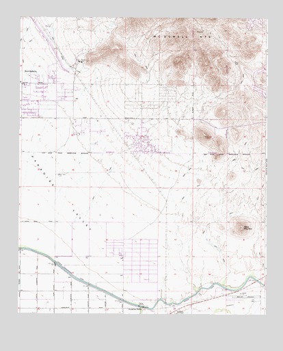
Sawik Mountain, AZ USGS Topographic Map
Click on map above to begin viewing in our Map Viewer.

This topographic map contains these locations and features:
Feature Name Type Latitude Longitude GNIS ID View Map
Anasazi Elementary SchoolSchoolN33.5962°W111.8121°2467208View Map
Ancala Country ClubLocaleN33.5939°W111.8286°2670030View Map
Ancala Village Shopping CenterLocaleN33.5867°W111.8377°2467033View Map
AndalusiaPopulated PlaceN33.5695°W111.8701°24714View Map
Beeline DragwayLocaleN33.5078°W111.7604°43163View Map
Cactus VillaPopulated PlaceN33.5884°W111.8551°24752View Map
Camelback Desert School Scottsdale CampusSchoolN33.5912°W111.8733°2517487View Map
Canon SpringSpringN33.6000°W111.8674°24014View Map
Casa RicaPopulated PlaceN33.5889°W111.8590°24764View Map
Cheyenne Traditional Elementary SchoolSchoolN33.5891°W111.8410°2466676View Map
Cheyenne Traditional SchoolSchoolN33.6099°W111.8658°2466631View Map
Chimney HillPopulated PlaceN33.5848°W111.8563°24782View Map
City of Grace ChurchChurchN33.5982°W111.8735°2670786View Map
Continental VillagePopulated PlaceN33.5695°W111.8588°24799View Map
Desert Mountain High SchoolSchoolN33.5886°W111.8090°2467362View Map
District DCivilN33.5337°W111.8586°2418923View Map
District GCivilN33.5182°W111.8044°2418926View Map
Eagle Mountain Golf ClubLocaleN33.5736°W111.7587°2670116View Map
Eagle Mountain Marketplace Shopping CenterLocaleN33.5790°W111.7604°2467065View Map
Ensenada del OroPopulated PlaceN33.5798°W111.8701°24850View Map
Evergreen StationLocaleN33.5031°W111.8126°4522View Map
Evergreen SubstationLocaleN33.5009°W111.7951°4523View Map
Fountain Hills Dam Number SevenDamN33.6067°W111.7504°36986View Map
Frank Lloyd Wright School of Architecture Taliesin West CampusSchoolN33.6069°W111.8457°2517529View Map
Haciendas del LagoPopulated PlaceN33.5778°W111.8718°24880View Map
HealthSouth Scottsdale Rehabilitation HospitalHospitalN33.5834°W111.8726°80012View Map
Heritage CourtPopulated PlaceN33.5817°W111.8579°24885View Map
Kingdom Hall of Jehovahs WitnessesChurchN33.5754°W111.8108°2671197View Map
Laguna Elementary SchoolSchoolN33.5784°W111.8567°2467484View Map
Landmark Pentecostal ChurchChurchN33.5793°W111.8138°2671536View Map
Little Lamb Community SchoolSchoolN33.5836°W111.8010°2467497View Map
Lost Dog WashArroyoN33.5858°W111.8261°2118217View Map
Mayo Clinic ScottsdaleBuildingN33.5841°W111.7951°2669779View Map
McDowell Mountain Community ChurchChurchN33.5834°W111.8143°2671573View Map
Meridian Point HospitalHospitalN33.5833°W111.8735°2467008View Map
MiradorPopulated PlaceN33.5778°W111.8646°24952View Map
Mission MontereyPopulated PlaceN33.5739°W111.8674°24953View Map
Mountainside Middle SchoolSchoolN33.5886°W111.8060°2467247View Map
Preston HillsPopulated PlaceN33.5848°W111.8674°25028View Map
Saddle Mountain Plaza Shopping CenterLocaleN33.5915°W111.7863°2467124View Map
Saint Anthony on the Desert Episcopal ChurchChurchN33.5835°W111.8008°2671262View Map
Saint Bernard of Clairvaux Catholic ChurchChurchN33.5853°W111.8128°2671270View Map
Salt River DivisionCivilN33.5576°W111.7527°1934977View Map
Salt River Fire Department Fire Station 293BuildingN33.5391°W111.8684°2672617View Map
Salt River LandfillLocaleN33.5089°W111.7788°2671965View Map
Salt River ReservationCivilN33.5198°W111.7939°37072View Map
Sanctuary Golf CourseLocaleN33.6169°W111.8595°2670477View Map
Sawik MountainSummitN33.5367°W111.7613°10974View Map
Scottsdale Fire Department Station 6BuildingN33.5866°W111.8470°2672577View Map
Scottsdale Fire Department Station 7 Rio MontanaBuildingN33.5874°W111.7977°2672578View Map
Scottsdale Fire Department Station 8 Cactus AcresBuildingN33.5977°W111.8744°2672719View Map
Scottsdale Public Library Palomino BranchBuildingN33.5885°W111.8109°2669479View Map
Scottsdale RanchPopulated PlaceN33.5750°W111.8582°25079View Map
Shepard of the Desert Lutheran SchoolSchoolN33.5830°W111.8750°2517446View Map
Shepherd of the Desert Lutheran ChurchChurchN33.5830°W111.8746°2671653View Map
Shiloh CanyonPopulated PlaceN33.5848°W111.8463°25090View Map
SunRidge Canyon Golf ClubLocaleN33.6106°W111.7516°2670046View Map
Taliesin OverlookGapN33.6183°W111.8267°2118215View Map
Taliesin WashArroyoN33.6067°W111.8547°2118216View Map
Taliesin WestPopulated PlaceN33.6070°W111.8432°24639View Map
Talking Stick Golf ClubLocaleN33.5450°W111.8651°2670048View Map
Via Linda Senior CenterBuildingN33.5762°W111.8553°2670564View Map

Note: Coordinates in the location and feature list above are referenced to NAD83 datum.


Copyright (C) 2008-2024 Ryan Niemi / Sunset Dynamics ... All Rights Reserved