TopoQuest Logo
Do you find TopoQuest useful?
Help keep TopoQuest running and adding new maps/features by donating!
Bitcoin:  19c7KJd3qBynnjoSw5npx9KScwjBe4ifkT
Litecoin:  LXs6TkuXGGXo1vDsWCkWVdjQX94eUKd6ui
Home View Maps Find Maps Find Places Resources & Links


Schoodic Head, Maine Topographic Map

USGS Map Title: Schoodic Head, ME
USGS Map MRC: 44068C1
DRG (GeoTIFF) Download: o44068c1.tif


Neighboring USGS Topographic Map Quads:


  Bar Harbor, ME  
44068D2
 

  Winter Harbor, ME  
44068D1
 

  Petit Manan Point, ME  
44067D8
 

  Seal Harbor, ME  
44068C2
 

  Schoodic Head, ME  
44068C1


  Baker Island, ME  
44068B2


Map MRC Location:

N45°
W69°
N45°
W68°
H8 H7 H6 H5 H4 H3 H2 H1
G8 G7 G6 G5 G4 G3 G2 G1
F8 F7 F6 F5 F4 F3 F2 F1
E8 E7 E6 E5 E4 E3 E2 E1
D8 D7 D6 D5 D4 D3 D2 D1
C8 C7 C6 C5 C4 C3 C2 C1
B8 B7 B6 B5 B4 B3 B2 B1
A8 A7 A6 A5 A4 A3 A2 A1
N44°
W69°
N44°
W68°

Schoodic Head, ME USGS 1:24K Topographic Map Preview:
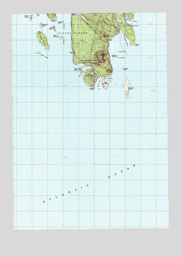
Schoodic Head, ME USGS Topographic Map
Click on map above to begin viewing in our Map Viewer.

This topographic map contains these locations and features:
Feature Name Type Latitude Longitude GNIS ID View Map
Alder Path TrailTrailN44.3426°W68.0525°1911334View Map
Arey CoveBayN44.3351°W68.0544°561286View Map
Big Moose IslandIslandN44.3367°W68.0622°562210View Map
Buck CoveBayN44.3598°W68.0453°1911443View Map
Buck Cove MountainSummitN44.3616°W68.0516°1911444View Map
Bunkers HarborBayN44.3695°W68.0272°563194View Map
East PondBayN44.3356°W68.0486°565667View Map
Frazer CreekStreamN44.3742°W68.0714°1911618View Map
Grindstone LedgeIslandN44.3695°W68.0883°580859View Map
Grindstone PointCapeN44.3717°W68.0886°567341View Map
Heron IslandIslandN44.3726°W68.1081°567961View Map
Little Moose IslandIslandN44.3334°W68.0500°569911View Map
Mark IslandIslandN44.3618°W68.0881°570781View Map
Middle LedgeBarN44.3498°W68.0317°580023View Map
Mountain BrookStreamN44.3667°W68.0383°1911787View Map
Mountain BrookStreamN44.3665°W68.0389°580861View Map
Ned IslandIslandN44.3659°W68.0903°581466View Map
Old WomanBarN44.3723°W68.0000°572737View Map
Pond IslandIslandN44.3429°W68.0700°581482View Map
Pulpit LedgeBarN44.3729°W68.0978°580690View Map
Ravens NestCliffN44.3520°W68.0747°574054View Map
Roaring BullBarN44.3676°W68.0939°581879View Map
Rolling IslandIslandN44.3501°W68.0403°574439View Map
Schoodic HarborBayN44.3512°W68.0347°574995View Map
Schoodic HeadSummitN44.3507°W68.0529°574996View Map
Schoodic Head TrailTrailN44.3451°W68.0653°1911910View Map
Schoodic IslandIslandN44.3317°W68.0325°574997View Map
Schoodic LedgeBarN44.3426°W68.0356°1911911View Map
Schoodic PeninsulaCapeN44.3667°W68.0581°575003View Map
Schoodic PointCapeN44.3306°W68.0489°575004View Map
Spectacle IslandIslandN44.3679°W68.1003°576003View Map
Spruce PointCapeN44.3576°W68.0256°576155View Map
The AnvilSummitN44.3416°W68.0466°576741View Map
The Anvil TrailTrailN44.3440°W68.0508°1912004View Map
The HeathSwampN44.3698°W68.0394°580860View Map
Town of Winter HarborCivilN44.3384°W68.0861°582821View Map
Turtle IslandIslandN44.3592°W68.0989°577451View Map
Turtle Island LedgeBarN44.3517°W68.1003°577454View Map
West PondBayN44.3429°W68.0661°578204View Map
White LedgeBarN44.3556°W68.0903°580022View Map
Winter HarborBayN44.3645°W68.0811°579095View Map
Winter Harbor LightLocaleN44.3601°W68.0878°1912096View Map
Wonsqueak HarborBayN44.3587°W68.0311°578642View Map

Note: Coordinates in the location and feature list above are referenced to NAD83 datum.


Copyright (C) 2008-2024 Ryan Niemi / Sunset Dynamics ... All Rights Reserved