TopoQuest Logo
Do you find TopoQuest useful?
Help keep TopoQuest running and adding new maps/features by donating!
Bitcoin:  19c7KJd3qBynnjoSw5npx9KScwjBe4ifkT
Litecoin:  LXs6TkuXGGXo1vDsWCkWVdjQX94eUKd6ui
Home View Maps Find Maps Find Places Resources & Links


Scranton, North Carolina Topographic Map

USGS Map Title: Scranton, NC
USGS Map MRC: 35076D4
DRG (GeoTIFF) Download: o35076d4.tif


Neighboring USGS Topographic Map Quads:


  Belhaven, NC  
35076E5
 

  Ponzer, NC  
35076E4
 

  New Lake SE, NC  
35076E3
 

  Pamlico Beach, NC  
35076D5
 

  Scranton, NC  
35076D4
 

  Swanquarter, NC  
35076D3
 

  Lowland, NC  
35076C5
 

  Pamlico Point, NC  
35076C4
 

  Great Island, NC  
35076C3


Map MRC Location:

N36°
W77°
N36°
W76°
H8 H7 H6 H5 H4 H3 H2 H1
G8 G7 G6 G5 G4 G3 G2 G1
F8 F7 F6 F5 F4 F3 F2 F1
E8 E7 E6 E5 E4 E3 E2 E1
D8 D7 D6 D5 D4 D3 D2 D1
C8 C7 C6 C5 C4 C3 C2 C1
B8 B7 B6 B5 B4 B3 B2 B1
A8 A7 A6 A5 A4 A3 A2 A1
N35°
W77°
N35°
W76°

Scranton, NC USGS 1:24K Topographic Map Preview:
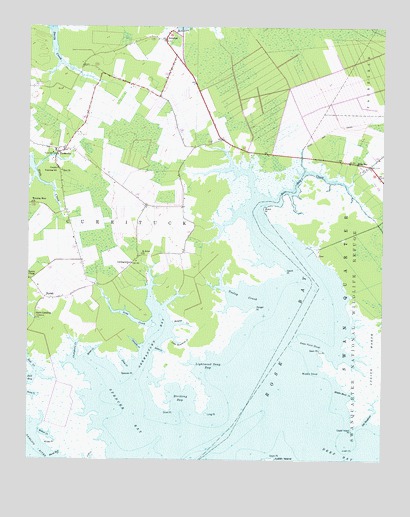
Scranton, NC USGS Topographic Map
Click on map above to begin viewing in our Map Viewer.

This topographic map contains these locations and features:
Feature Name Type Latitude Longitude GNIS ID View Map
Bell BayBayN35.3985°W76.4999°1019064View Map
Bell CreekStreamN35.3996°W76.4969°980937View Map
Bell Island Recreation AreaAreaN35.4354°W76.3977°1018689View Map
Berry CreekBayN35.3941°W76.4996°981040View Map
BeulahPopulated PlaceN35.4216°W76.4933°981256View Map
Chellybelle CreekStreamN35.4029°W76.4827°983068View Map
Ditch CreekStreamN35.4016°W76.4646°984210View Map
Drum PointCapeN35.3760°W76.4124°984347View Map
Eunice ChapelChurchN35.4274°W76.4991°984842View Map
GermantownPopulated PlaceN35.4318°W76.4630°1020420View Map
Germantown BayBayN35.4171°W76.4527°985640View Map
Hodges Farm AirportAirportN35.4388°W76.4494°997927View Map
House CreekStreamN35.4049°W76.4771°987169View Map
Hyde County Training SchoolSchoolN35.4588°W76.4899°1008331View Map
Island PointCapeN35.4296°W76.4091°987434View Map
Jeanette CreekStreamN35.4068°W76.4599°987536View Map
Lightwood Snag BayBayN35.4010°W76.4377°988480View Map
Little Hammock CreekStreamN35.4104°W76.4483°988659View Map
Long CreekStreamN35.4157°W76.4555°988952View Map
Long PointCapeN35.3882°W76.4366°988988View Map
Marsh Rock CreekBayN35.3771°W76.4885°989372View Map
Middle ShoalBarN35.4016°W76.3991°989798View Map
Middle Shoal CreekBayN35.3935°W76.3874°989799View Map
Midgette CreekStreamN35.4141°W76.4483°989813View Map
Old HauloverStreamN35.3857°W76.3794°991564View Map
Ranger PointCapeN35.4188°W76.4196°993030View Map
Rose BayBayN35.4138°W76.4083°993683View Map
Rose BayPopulated PlaceN35.4607°W76.3835°1022392View Map
Rose Bay CreekStreamN35.4499°W76.4174°993685View Map
Saint Johns ChurchChurchN35.4346°W76.4596°993946View Map
ScrantonPopulated PlaceN35.4971°W76.4513°994440View Map
Scranton Post OfficePost OfficeN35.4955°W76.4520°2774118View Map
Scranton Volunteer Fire DepartmentBuildingN35.4647°W76.4901°2638244View Map
Short PointCapeN35.3896°W76.4496°994772View Map
SladesvillePopulated PlaceN35.4638°W76.4894°994901View Map
Spencer BayBayN35.3871°W76.4644°995291View Map
Spencer PointCapeN35.4004°W76.4666°995295View Map
Stave LandingLocaleN35.4179°W76.4969°1022782View Map
Striking BayBayN35.3913°W76.4455°995613View Map
Swan CreekStreamN35.4077°W76.4535°995743View Map
Swan PointCapeN35.4068°W76.3969°995752View Map
Swan Point ShoalBarN35.4099°W76.4013°995753View Map
Swanquarter National Wildlife RefugeParkN35.4180°W76.3775°995763View Map
Tooley CreekBayN35.4224°W76.4238°996159View Map
Upper Island PointCapeN35.3841°W76.3849°996553View Map
Watch PointCapeN35.4477°W76.4166°996838View Map
Weeping Mary ChurchChurchN35.4491°W76.4985°996925View Map
Willow CreekBayN35.3818°W76.4913°997416View Map
Willow PointCapeN35.3804°W76.4930°997420View Map
Zion ChurchChurchN35.4582°W76.4883°997766View Map

Note: Coordinates in the location and feature list above are referenced to NAD83 datum.


Copyright (C) 2008-2024 Ryan Niemi / Sunset Dynamics ... All Rights Reserved