TopoQuest Logo
Do you find TopoQuest useful?
Help keep TopoQuest running and adding new maps/features by donating!
Bitcoin:  19c7KJd3qBynnjoSw5npx9KScwjBe4ifkT
Litecoin:  LXs6TkuXGGXo1vDsWCkWVdjQX94eUKd6ui
Home View Maps Find Maps Find Places Resources & Links


Sea Island, Georgia Topographic Map

USGS Map Title: Sea Island, GA
USGS Map MRC: 31081B3
DRG (GeoTIFF) Download: o31081b3.tif


Neighboring USGS Topographic Map Quads:


  Darien, GA  
31081C4
 

  Altamaha Sound, GA  
31081C3


  Brunswick East, GA  
31081B4
 

  Sea Island, GA  
31081B3


  Jekyll Island, GA  
31081A4


Map MRC Location:

N32°
W82°
N32°
W81°
H8 H7 H6 H5 H4 H3 H2 H1
G8 G7 G6 G5 G4 G3 G2 G1
F8 F7 F6 F5 F4 F3 F2 F1
E8 E7 E6 E5 E4 E3 E2 E1
D8 D7 D6 D5 D4 D3 D2 D1
C8 C7 C6 C5 C4 C3 C2 C1
B8 B7 B6 B5 B4 B3 B2 B1
A8 A7 A6 A5 A4 A3 A2 A1
N31°
W82°
N31°
W81°

Sea Island, GA USGS 1:24K Topographic Map Preview:
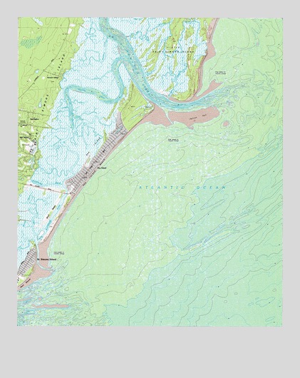
Sea Island, GA USGS Topographic Map
Click on map above to begin viewing in our Map Viewer.

This topographic map contains these locations and features:
Feature Name Type Latitude Longitude GNIS ID View Map
Black BanksLeveeN31.1713°W81.3587°311462View Map
Blackbank RiverChannelN31.1827°W81.3590°354754View Map
Bloody MarshSwampN31.1596°W81.3731°311528View Map
German VillagePopulated PlaceN31.2219°W81.3576°331804View Map
German Village Plantation (historical)LocaleN31.2258°W81.3554°1671504View Map
Glynn County Fire Department Station 7BuildingN31.2482°W81.3511°2603639View Map
Glynn County Police Department Sea Island SubstationBuildingN31.1800°W81.3581°2733488View Map
Goulds InletChannelN31.1597°W81.3657°314738View Map
Hampton RiverStreamN31.2158°W81.3059°315077View Map
HarringtonPopulated PlaceN31.2066°W81.3701°331917View Map
Mosquito CreekStreamN31.2400°W81.2848°318527View Map
Ocean Forest Golf ClubLocaleN31.2125°W81.3215°2502690View Map
Pelican SpitBarN31.2097°W81.2951°320352View Map
Postell CreekStreamN31.1619°W81.3662°321088View Map
Saint Simons DivisionCivilN31.2178°W81.3111°1936522View Map
Saint Simons IslandIslandN31.2183°W81.3612°356512View Map
Saint Simons IslandPopulated PlaceN31.1505°W81.3695°332958View Map
Sea IslandIslandN31.2002°W81.3332°322673View Map
Sea IslandPopulated PlaceN31.1836°W81.3498°333000View Map
Sea Island BeachBeachN31.1894°W81.3376°322674View Map
Sea Island Post OfficePost OfficeN31.1837°W81.3744°2502495View Map
Sea Palms Golf ClubLocaleN31.1988°W81.3707°1671591View Map
Village BluffPopulated PlaceN31.2263°W81.3582°1671602View Map
Village CreekChannelN31.2200°W81.3390°324709View Map

Note: Coordinates in the location and feature list above are referenced to NAD83 datum.


Copyright (C) 2008-2024 Ryan Niemi / Sunset Dynamics ... All Rights Reserved