TopoQuest Logo
Do you find TopoQuest useful?
Help keep TopoQuest running and adding new maps/features by donating!
Bitcoin:  19c7KJd3qBynnjoSw5npx9KScwjBe4ifkT
Litecoin:  LXs6TkuXGGXo1vDsWCkWVdjQX94eUKd6ui
Home View Maps Find Maps Find Places Resources & Links


Sears Point, California Topographic Map

USGS Map Title: Sears Point, CA
USGS Map MRC: 38122B4
DRG (GeoTIFF) Download: o38122b4.tif


Neighboring USGS Topographic Map Quads:


  Glen Ellen, CA  
38122C5
 

  Sonoma, CA  
38122C4
 

  Napa, CA  
38122C3
 

  Petaluma River, CA  
38122B5
 

  Sears Point, CA  
38122B4
 

  Cuttings Wharf, CA  
38122B3
 

  Novato, CA  
38122A5
 

  Petaluma Point, CA  
38122A4
 

  Mare Island, CA  
38122A3


Map MRC Location:

N39°
W123°
N39°
W122°
H8 H7 H6 H5 H4 H3 H2 H1
G8 G7 G6 G5 G4 G3 G2 G1
F8 F7 F6 F5 F4 F3 F2 F1
E8 E7 E6 E5 E4 E3 E2 E1
D8 D7 D6 D5 D4 D3 D2 D1
C8 C7 C6 C5 C4 C3 C2 C1
B8 B7 B6 B5 B4 B3 B2 B1
A8 A7 A6 A5 A4 A3 A2 A1
N38°
W123°
N38°
W122°

Sears Point, CA USGS 1:24K Topographic Map Preview:
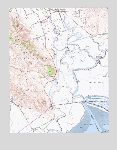
Sears Point, CA USGS Topographic Map
Click on map above to begin viewing in our Map Viewer.

This topographic map contains these locations and features:
Feature Name Type Latitude Longitude GNIS ID View Map
Arroyo SecoStreamN38.2449°W122.4347°218408View Map
Big BendPopulated PlaceN38.2363°W122.4622°219133View Map
Bush SloughGutN38.1783°W122.4311°220264View Map
Camp FourLocaleN38.2121°W122.4041°220458View Map
Camp OneLocaleN38.1944°W122.4350°220477View Map
Camp SixLocaleN38.1769°W122.4158°220489View Map
Camp ThreeLocaleN38.2005°W122.4233°220493View Map
Camp TwoLocaleN38.2227°W122.4380°220497View Map
China SloughGutN38.2033°W122.4125°221058View Map
Cline Cellars WineryLocaleN38.2138°W122.4583°1799824View Map
East BranchGutN38.1708°W122.4308°222851View Map
EmbarcaderoPopulated PlaceN38.2399°W122.4497°1702051View Map
FairvillePopulated PlaceN38.1780°W122.4455°1658523View Map
Fairville QuarryMineN38.1875°W122.4403°2677517View Map
Fowler CreekStreamN38.2410°W122.4525°223770View Map
Gloria Ferrer WineryLocaleN38.2277°W122.4594°1799835View Map
Goose LakeLakeN38.2052°W122.4813°224324View Map
Gravelly LakeLakeN38.2133°W122.4929°224494View Map
Greenwood (historical)Populated PlaceN38.1327°W122.4608°1702052View Map
Homewood WineryLocaleN38.2446°W122.4203°1799838View Map
Infineon RacewayLocaleN38.1608°W122.4539°1799872View Map
Island Land ClubLocaleN38.1260°W122.4364°226008View Map
Lee LakeLakeN38.2194°W122.4981°226993View Map
McGillPopulated PlaceN38.1985°W122.4366°252734View Map
Naval Supply Detachment MontereyMilitaryN38.1766°W122.3932°2511946View Map
North BranchGutN38.1791°W122.4397°229603View Map
Railroad SloughGutN38.2266°W122.4353°231180View Map
Rainbow SloughGutN38.1921°W122.3853°231189View Map
RamalPopulated PlaceN38.2213°W122.3947°1659461View Map
ReclamationLocaleN38.1288°W122.4714°231306View Map
Roche WineryLocaleN38.1741°W122.4525°1799868View Map
Rodgers CreekStreamN38.2488°W122.4619°231809View Map
Rose School (historical)SchoolN38.1549°W122.4944°1702054View Map
San Pablo Bay National Wildlife RefugeParkN38.1332°W122.3877°277262View Map
Schell - Vista Fire Protection District Station 1 HeadquartersBuildingN38.2441°W122.4478°2623778View Map
Schell CreekStreamN38.2382°W122.4325°232645View Map
Schell SloughStreamN38.2282°W122.4247°232647View Map
SchellvillePopulated PlaceN38.2460°W122.4397°252789View Map
Sears PointPopulated PlaceN38.1510°W122.4478°252790View Map
Second Napa SloughGutN38.1916°W122.3930°232776View Map
Shellville ColonyPopulated PlaceN38.2438°W122.4169°1702055View Map
Skaggs IslandIslandN38.1750°W122.3833°2790986View Map
Sleepy Hollow 2 426 DamDamN38.1583°W122.4944°1663883View Map
Sleepy Hollow RanchLocaleN38.1588°W122.4961°1732500View Map
Sonoma CreekStreamN38.1505°W122.4036°234882View Map
Sonoma Creek WineryLocaleN38.2371°W122.4475°1799875View Map
Sonoma ValleyValleyN38.2083°W122.4178°234890View Map
Sonoma Valley AirportAirportN38.2237°W122.4539°1653997View Map
Sonoma Valley ClubLocaleN38.2135°W122.4289°234891View Map
Steamboat SloughGutN38.2210°W122.4247°235419View Map
Sweetwater ClubLocaleN38.2230°W122.3841°235894View Map
Third Napa SloughGutN38.2071°W122.4039°236244View Map
Tubbs IslandIslandN38.1496°W122.4241°236586View Map
Tule Vista SchoolSchoolN38.2455°W122.4180°236609View Map
Viansa WineryLocaleN38.2027°W122.4458°1799877View Map
West End Land ClubLocaleN38.1588°W122.3869°1654510View Map
Wildcat MountainSummitN38.1944°W122.4739°237802View Map
WingoPopulated PlaceN38.2091°W122.4266°1660194View Map

Note: Coordinates in the location and feature list above are referenced to NAD83 datum.


Copyright (C) 2008-2024 Ryan Niemi / Sunset Dynamics ... All Rights Reserved