TopoQuest Logo
Do you find TopoQuest useful?
Help keep TopoQuest running and adding new maps/features by donating!
Bitcoin:  19c7KJd3qBynnjoSw5npx9KScwjBe4ifkT
Litecoin:  LXs6TkuXGGXo1vDsWCkWVdjQX94eUKd6ui
Home View Maps Find Maps Find Places Resources & Links


Seligman West, Arizona Topographic Map

USGS Map Title: Seligman West, AZ
USGS Map MRC: 35112C8
DRG (GeoTIFF) Download: o35112c8.tif


Neighboring USGS Topographic Map Quads:


  Audley, AZ  
35113D1
 

  Red Mesa, AZ  
35112D8
 

  Trinity Mountain, AZ  
35112D7
 

  Yampai SE, AZ  
35113C1
 

  Seligman West, AZ  
35112C8
 

  Seligman East, AZ  
35112C7
 

  Squaw Peak, AZ  
35113B1
 

  Purcell Canyon, AZ  
35112B8
 

  Turkey Canyon NE, AZ  
35112B7


Map MRC Location:

N36°
W113°
N36°
W112°
H8 H7 H6 H5 H4 H3 H2 H1
G8 G7 G6 G5 G4 G3 G2 G1
F8 F7 F6 F5 F4 F3 F2 F1
E8 E7 E6 E5 E4 E3 E2 E1
D8 D7 D6 D5 D4 D3 D2 D1
C8 C7 C6 C5 C4 C3 C2 C1
B8 B7 B6 B5 B4 B3 B2 B1
A8 A7 A6 A5 A4 A3 A2 A1
N35°
W113°
N35°
W112°

Seligman West, AZ USGS 1:24K Topographic Map Preview:
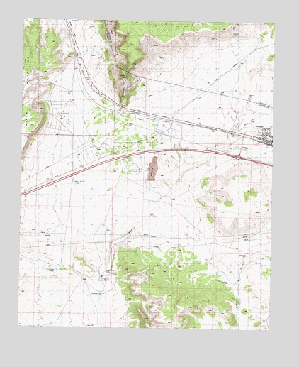
Seligman West, AZ USGS Topographic Map
Click on map above to begin viewing in our Map Viewer.

This topographic map contains these locations and features:
Feature Name Type Latitude Longitude GNIS ID View Map
Aubrey ValleyValleyN35.2997°W112.9705°886View Map
Buck Rogers WellWellN35.2642°W112.9588°21199View Map
Canyon Mouth DamDamN35.2722°W112.9557°21211View Map
Chino PointCliffN35.3453°W112.9499°21219View Map
Chino PointCliffN35.3508°W112.9463°2867View Map
Chino StationLocaleN35.3319°W112.9413°2871View Map
Chino WashStreamN35.2628°W112.9599°2873View Map
Chino WellWellN35.3458°W112.9766°21221View Map
Fox DamDamN35.2958°W112.9341°21269View Map
Quintanna TankReservoirN35.2735°W112.9826°21393View Map
Railroad EmbankmentDamN35.3200°W112.8974°21395View Map
Railroad Embankment ReservoirReservoirN35.3200°W112.8974°21396View Map
Red MesaSummitN35.3710°W112.9375°2707688View Map
Santa Fe WellsWellN35.2703°W112.9591°21419View Map
SeligmanPopulated PlaceN35.3256°W112.8774°11070View Map
Seligman AirportAirportN35.3336°W112.8874°45497View Map
Seligman DamDamN35.3231°W112.8896°21424View Map
Seligman Fire DistrictBuildingN35.3278°W112.8793°2672583View Map
Seligman Post OfficePost OfficeN35.3276°W112.8827°44894View Map
Seligman Railroad StationBuildingN35.3258°W112.8766°21428View Map
Shorty TankReservoirN35.3088°W112.9740°21441View Map
West Seligman InterchangeCrossingN35.3203°W112.8930°21492View Map

Note: Coordinates in the location and feature list above are referenced to NAD83 datum.


Copyright (C) 2008-2025 Ryan Niemi / Sunset Dynamics ... All Rights Reserved