TopoQuest Logo
Do you find TopoQuest useful?
Help keep TopoQuest running and adding new maps/features by donating!
Bitcoin:  19c7KJd3qBynnjoSw5npx9KScwjBe4ifkT
Litecoin:  LXs6TkuXGGXo1vDsWCkWVdjQX94eUKd6ui
Home View Maps Find Maps Find Places Resources & Links


Seneca, Kansas Topographic Map

USGS Map Title: Seneca, KS
USGS Map MRC: 39096G1
DRG (GeoTIFF) Download: o39096g1.tif


Neighboring USGS Topographic Map Quads:


  Seneca NW, KS  
39096H2
 

  Saint Benedict, KS  
39096H1
 

  Bern, KS  
39095H8
 

  Baileyville, KS  
39096G2
 

  Seneca, KS  
39096G1
 

  Oneida, KS  
39095G8
 

  Centralia, KS  
39096F2
 

  Corning, KS  
39096F1
 

  Goff, KS  
39095F8


Map MRC Location:

N40°
W97°
N40°
W96°
H8 H7 H6 H5 H4 H3 H2 H1
G8 G7 G6 G5 G4 G3 G2 G1
F8 F7 F6 F5 F4 F3 F2 F1
E8 E7 E6 E5 E4 E3 E2 E1
D8 D7 D6 D5 D4 D3 D2 D1
C8 C7 C6 C5 C4 C3 C2 C1
B8 B7 B6 B5 B4 B3 B2 B1
A8 A7 A6 A5 A4 A3 A2 A1
N39°
W97°
N39°
W96°

Seneca, KS USGS 1:24K Topographic Map Preview:
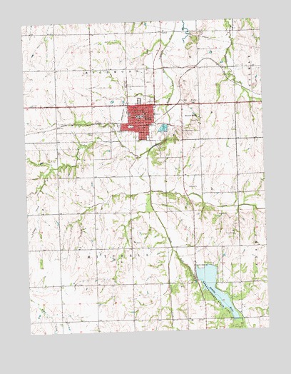
Seneca, KS USGS Topographic Map
Click on map above to begin viewing in our Map Viewer.

This topographic map contains these locations and features:
Feature Name Type Latitude Longitude GNIS ID View Map
Blair Grain ElevatorLocaleN39.8335°W96.0676°2695141View Map
Church of the Coming KingChurchN39.8310°W96.0736°2690935View Map
City of SenecaCivilN39.8377°W96.0691°485651View Map
Fisher CreekStreamN39.8231°W96.0603°472945View Map
Flying H AirportAirportN39.7535°W96.0279°2717306View Map
Heinen AirportAirportN39.7826°W96.0022°2770573View Map
Illinois CreekStreamN39.7828°W96.0497°472953View Map
Kansas Highway Patrol Troop B NemahaBuildingN39.8371°W96.0646°2504276View Map
KMZA - FM (Seneca)BuildingN39.8259°W96.0296°2625294View Map
Marshall-Nemaha SchoolSchoolN39.8344°W96.0631°480220View Map
Maxwell SpringSpringN39.8369°W96.0344°472951View Map
Nemaha Central High SchoolSchoolN39.8376°W96.0718°480223View Map
Nemaha CountyCivilN39.7834°W96.0141°485029View Map
Nemaha County CourthouseBuildingN39.8367°W96.0646°2625126View Map
Nemaha County Historical MuseumBuildingN39.8360°W96.0636°2694237View Map
Nemaha County JailBuildingN39.8370°W96.0644°2504365View Map
Nemaha County Sheriff's OfficeBuildingN39.8370°W96.0644°2504133View Map
Nemaha County State LakeReservoirN39.7733°W96.0369°479897View Map
Nemaha County State Lake DamDamN39.7733°W96.0369°479896View Map
Nemaha County State ParkParkN39.7617°W96.0267°472954View Map
Nemaha State Fishing Lake and Wildlife AreaParkN39.7617°W96.0267°479770View Map
Nemaha Valley Community HospitalHospitalN39.8371°W96.0781°2499101View Map
Nemaha Valley Elementary and Middle SchoolSchoolN39.8361°W96.0719°480222View Map
Nemaha Valley School District OfficesSchoolN39.8345°W96.0582°2506461View Map
New Hope Baptist ChurchChurchN39.8409°W96.0926°2690689View Map
Saint Benedict Junior High SchoolSchoolN39.8378°W96.0617°480225View Map
Saints Peter and Paul Catholic ChurchChurchN39.8378°W96.0618°2690659View Map
Saints Peter and Paul CemeteryCemeteryN39.8497°W96.0711°472956View Map
Saints Peter and Paul SchoolSchoolN39.8387°W96.0622°472957View Map
SenecaPopulated PlaceN39.8342°W96.0642°472949View Map
Seneca City Fire DepartmentBuildingN39.8346°W96.0643°2111858View Map
Seneca City HallBuildingN39.8345°W96.0637°2693215View Map
Seneca Emergency Medical ServicesBuildingN39.8346°W96.0642°2696428View Map
Seneca Free LibraryBuildingN39.8340°W96.0646°2694777View Map
Seneca Grade SchoolSchoolN39.8369°W96.0661°480221View Map
Seneca Mobile Home ParkPopulated PlaceN39.8276°W96.0632°2694158View Map
Seneca Municipal AirportAirportN39.8430°W96.1173°472950View Map
Seneca Police DepartmentBuildingN39.8370°W96.0644°2503927View Map
Seneca Post OfficePost OfficeN39.8345°W96.0646°2693968View Map
Seneca Sewer Treatment PlantLocaleN39.8308°W96.0522°2692135View Map
Seneca United Methodist ChurchChurchN39.8340°W96.0656°2689546View Map
Spring Creek Golf ClubLocaleN39.8454°W96.0805°2694534View Map
Tennessee CreekStreamN39.8067°W96.0600°472952View Map
Township of MitchellCivilN39.7835°W96.0704°472944View Map
Township of RichmondCivilN39.8721°W96.0704°472720View Map

Note: Coordinates in the location and feature list above are referenced to NAD83 datum.


Copyright (C) 2008-2025 Ryan Niemi / Sunset Dynamics ... All Rights Reserved