TopoQuest Logo
Do you find TopoQuest useful?
Help keep TopoQuest running and adding new maps/features by donating!
Bitcoin:  19c7KJd3qBynnjoSw5npx9KScwjBe4ifkT
Litecoin:  LXs6TkuXGGXo1vDsWCkWVdjQX94eUKd6ui
Home View Maps Find Maps Find Places Resources & Links


Shandon, Ohio Topographic Map

USGS Map Title: Shandon, OH
USGS Map MRC: 39084C6
DRG (GeoTIFF) Download: o39084c6.tif


Neighboring USGS Topographic Map Quads:


  Reily, OH  
39084D7
 

  Millville, OH  
39084D6
 

  Hamilton, OH  
39084D5
 

  Harrison, OH  
39084C7
 

  Shandon, OH  
39084C6
 

  Greenhills, OH  
39084C5
 

  Hooven, OH  
39084B7
 

  Addyston, OH  
39084B6
 

  Cincinnati West, OH  
39084B5


Map MRC Location:

N40°
W85°
N40°
W84°
H8 H7 H6 H5 H4 H3 H2 H1
G8 G7 G6 G5 G4 G3 G2 G1
F8 F7 F6 F5 F4 F3 F2 F1
E8 E7 E6 E5 E4 E3 E2 E1
D8 D7 D6 D5 D4 D3 D2 D1
C8 C7 C6 C5 C4 C3 C2 C1
B8 B7 B6 B5 B4 B3 B2 B1
A8 A7 A6 A5 A4 A3 A2 A1
N39°
W85°
N39°
W84°

Shandon, OH USGS 1:24K Topographic Map Preview:
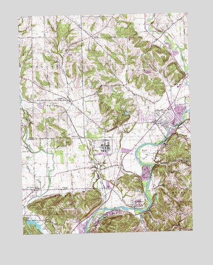
Shandon, OH USGS Topographic Map
Click on map above to begin viewing in our Map Viewer.

This topographic map contains these locations and features:
Feature Name Type Latitude Longitude GNIS ID View Map
Atomic ViewPopulated PlaceN39.3114°W84.6744°2353371View Map
BirdlandPopulated PlaceN39.3114°W84.6433°2353374View Map
Blue Rock CreekStreamN39.2614°W84.6630°1056225View Map
Butterfield CemeteryCemeteryN39.3084°W84.6549°1038572View Map
Camp Fort ScottLocaleN39.2742°W84.6658°1038696View Map
Camp Ross TrailLocaleN39.3212°W84.6736°1048314View Map
Camp Ross Trails LakeReservoirN39.3180°W84.6716°1077912View Map
Camp Ross Trails Lake DamDamN39.3167°W84.6699°1077911View Map
Chapel CemeteryCemeteryN39.3342°W84.7405°1038987View Map
Colerain Township Department of Fire and Emergency Medical Services Training CenterBuildingN39.3031°W84.6324°2550327View Map
Crawford CemeteryCemeteryN39.2592°W84.6714°2089639View Map
Crosby Elementary SchoolSchoolN39.2762°W84.7172°1059665View Map
Crosby Township Fire Department Station 27BuildingN39.2645°W84.6666°2549201View Map
Crosby Township Fire Department Station 28BuildingN39.2756°W84.7422°2549534View Map
Crosby United Methodist ChurchChurchN39.2770°W84.7399°1064059View Map
Dever PondReservoirN39.3143°W84.7279°1079364View Map
Dever Pond DamDamN39.3134°W84.7283°1079363View Map
Dry Ridge Census Designated PlaceCensusN39.2587°W84.6339°2585507View Map
Dry RunStreamN39.3006°W84.6533°1039813View Map
Dunlap Census Designated PlaceCensusN39.2908°W84.6303°2585508View Map
Dunlap RunStreamN39.2889°W84.6527°1066691View Map
Elda Elementary SchoolSchoolN39.3201°W84.6405°1081258View Map
Feed Materials Production Center (historical)LocaleN39.2994°W84.6886°2094773View Map
FernaldPopulated PlaceN39.2756°W84.6897°1064648View Map
First Baptist Church of RossChurchN39.3187°W84.6499°1063729View Map
Fort ScottPopulated PlaceN39.2709°W84.6597°1062476View Map
Fort Scott Camps Post Office (historical)Post OfficeN39.2709°W84.6597°1926730View Map
Hedges CemeteryCemeteryN39.2939°W84.6561°1041459View Map
Howard CreekStreamN39.2723°W84.7358°436537View Map
Indian CreekStreamN39.3195°W84.6269°436742View Map
LayhighPopulated PlaceN39.3617°W84.6961°1064976View Map
Miami Whitewater Forest DamDamN39.2601°W84.7466°1077945View Map
Miami Whitewater Forest LakeReservoirN39.2548°W84.7391°1077946View Map
Morgan Township Volunteer Fire Department Okeana StationBuildingN39.3393°W84.7419°2549446View Map
Morgan Township Volunteer Fire Department Shandon StationBuildingN39.3260°W84.7143°2549254View Map
Mount Hope Pet CemeteryCemeteryN39.2559°W84.7277°1043575View Map
New BaltimorePopulated PlaceN39.2648°W84.6674°1065109View Map
New Baltimore Census Designated PlaceCensusN39.2743°W84.6705°2585516View Map
New HavenPopulated PlaceN39.2756°W84.7408°1065119View Map
New Haven CemeteryCemeteryN39.2787°W84.7402°1960288View Map
New Haven Census Designated PlaceCensusN39.2773°W84.7446°2585518View Map
New Haven United Methodist ChurchChurchN39.2751°W84.7405°1064060View Map
New London CemeteryCemeteryN39.3256°W84.7277°1043840View Map
Owl CreekStreamN39.2731°W84.6580°1044255View Map
Paddys RunStreamN39.2642°W84.6913°1044270View Map
Raylene AirportAirportN39.2952°W84.7499°1082732View Map
RossPopulated PlaceN39.3123°W84.6505°1061628View Map
Ross Census Designated PlaceCensusN39.3146°W84.6599°2393217View Map
Ross High SchoolSchoolN39.3337°W84.6316°1045205View Map
Ross Middle SchoolSchoolN39.3323°W84.6330°1052615View Map
Ross Post OfficePost OfficeN39.3126°W84.6499°1965268View Map
Ross Township CemeteryCemeteryN39.3614°W84.6924°1806446View Map
Ross Township Fire Department Station 1BuildingN39.3114°W84.6501°2549453View Map
Sater CemeteryCemeteryN39.2878°W84.7311°1045970View Map
School Number 5 (historical)SchoolN39.3531°W84.6849°1069312View Map
School Number 6 (historical)SchoolN39.3634°W84.6524°1069313View Map
Scott CemeteryCemeteryN39.2757°W84.6848°1046054View Map
Shaker CemeteryCemeteryN39.2910°W84.7409°1046122View Map
Shaker Village (historical)Populated PlaceN39.2931°W84.7405°1059666View Map
ShandonPopulated PlaceN39.3264°W84.7147°1079590View Map
Shandon CemeteryCemeteryN39.3253°W84.7127°1806451View Map
Shandon Post OfficePost OfficeN39.3264°W84.7152°1965274View Map
Shandon StationLocaleN39.3062°W84.7074°1046128View Map
Shandon United Church of ChristChurchN39.3270°W84.7161°1063728View Map
Township of ColerainCivilN39.2541°W84.6256°1086202View Map
Township of CrosbyCivilN39.2788°W84.7144°1086204View Map
Township of RossCivilN39.3506°W84.6541°1085819View Map
United Brethren CemeteryCemeteryN39.2592°W84.6314°2089641View Map
Venice CemeteryCemeteryN39.3181°W84.6522°1047437View Map
Venice Presbyterian ChurchChurchN39.3134°W84.6505°1063730View Map
Venice United Methodist ChurchChurchN39.3126°W84.6494°1063731View Map

Note: Coordinates in the location and feature list above are referenced to NAD83 datum.


Copyright (C) 2008-2024 Ryan Niemi / Sunset Dynamics ... All Rights Reserved