TopoQuest Logo
Do you find TopoQuest useful?
Help keep TopoQuest running and adding new maps/features by donating!
Bitcoin:  19c7KJd3qBynnjoSw5npx9KScwjBe4ifkT
Litecoin:  LXs6TkuXGGXo1vDsWCkWVdjQX94eUKd6ui
Home View Maps Find Maps Find Places Resources & Links


Shell Rock, Iowa Topographic Map

USGS Map Title: Shell Rock, IA
USGS Map MRC: 42092F5
DRG (GeoTIFF) Download: o42092f5.tif


Neighboring USGS Topographic Map Quads:


  Clarksville, IA  
42092G6
 

  Plainfield, IA  
42092G5
 

  Bremer, IA  
42092G4
 

  Coster, IA  
42092F6
 

  Shell Rock, IA  
42092F5
 

  Waverly, IA  
42092F4
 

  Stout, IA  
42092E6
 

  New Hartford, IA  
42092E5
 

  Cedar Falls, IA  
42092E4


Map MRC Location:

N43°
W93°
N43°
W92°
H8 H7 H6 H5 H4 H3 H2 H1
G8 G7 G6 G5 G4 G3 G2 G1
F8 F7 F6 F5 F4 F3 F2 F1
E8 E7 E6 E5 E4 E3 E2 E1
D8 D7 D6 D5 D4 D3 D2 D1
C8 C7 C6 C5 C4 C3 C2 C1
B8 B7 B6 B5 B4 B3 B2 B1
A8 A7 A6 A5 A4 A3 A2 A1
N42°
W93°
N42°
W92°

Shell Rock, IA USGS 1:24K Topographic Map Preview:
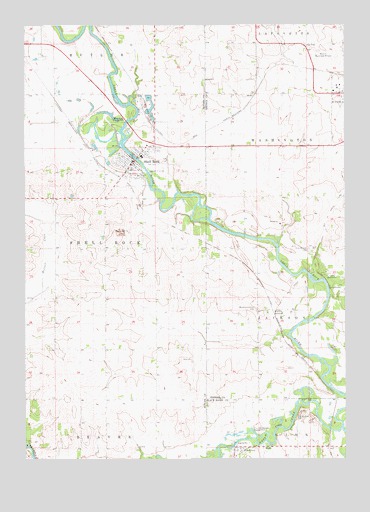
Shell Rock, IA USGS Topographic Map
Click on map above to begin viewing in our Map Viewer.

This topographic map contains these locations and features:
Feature Name Type Latitude Longitude GNIS ID View Map
Benny Gambaiani Public LibraryBuildingN42.7108°W92.5821°1945416View Map
Camp HeyataLocaleN42.6750°W92.5057°455121View Map
Camp WahpatonLocaleN42.6783°W92.5082°455134View Map
Cherry Street BridgeBridgeN42.7116°W92.5819°1945558View Map
City of Shell RockCivilN42.7122°W92.5819°2395870View Map
Curry CreekStreamN42.7275°W92.5846°465375View Map
Faith Lutheran ChurchChurchN42.7136°W92.5769°1945427View Map
Family Health Center - Shell RockHospitalN42.7097°W92.5835°1945422View Map
Farmers Co-op ElevatorLocaleN42.7066°W92.5871°1945417View Map
FinchfordPopulated PlaceN42.6272°W92.5438°456590View Map
Finchford CemeteryCemeteryN42.6267°W92.5396°1958318View Map
Finchford Community ChurchChurchN42.6278°W92.5419°2002131View Map
Finchford Post Office (historical)Post OfficeN42.6272°W92.5438°2001908View Map
First Baptist ChurchChurchN42.7114°W92.5846°1945425View Map
Jehovahs Witnesses Kingdom HallChurchN42.7141°W92.5799°1945429View Map
Klock CreekStreamN42.6608°W92.5241°465373View Map
Maxwell Chiropractic ClinicHospitalN42.7105°W92.5832°1945421View Map
Peace Lutheran ChurchChurchN42.7097°W92.5821°1945426View Map
PILOT MOUND CEMETERYCemeteryN42.6857°W92.5144°460156View Map
Riverside CemeteryCemeteryN42.7133°W92.5882°1945424View Map
Shell RockPopulated PlaceN42.7103°W92.5830°461561View Map
Shell RockLocaleN42.7066°W92.5871°1945418View Map
Shell Rock Access AreaParkN42.6791°W92.5141°1948270View Map
Shell Rock Ambulance ServiceBuildingN42.7106°W92.5835°2599970View Map
Shell Rock BridgeBridgeN42.7116°W92.5819°1945557View Map
Shell Rock County ParkParkN42.7230°W92.5907°461562View Map
Shell Rock Elementary SchoolSchoolN42.7122°W92.5796°1945430View Map
Shell Rock Fire StationBuildingN42.7105°W92.5835°1945415View Map
Shell Rock Health Care CenterHospitalN42.7150°W92.5744°1945423View Map
Shell Rock Police DepartmentBuildingN42.7101°W92.5835°1945419View Map
Shell Rock Post OfficePost OfficeN42.7114°W92.5838°1945420View Map
Shell Rock RiverStreamN42.6341°W92.5013°461563View Map
Shell Rock Wildlife AreaParkN42.7222°W92.5946°1945377View Map
Shell Rock Wildlife AreaParkN42.6528°W92.5113°1948269View Map
Thunder Woman County ParkParkN42.6316°W92.5363°462236View Map
Township of Shell RockCivilN42.6863°W92.6137°468689View Map
United Methodist ChurchChurchN42.7097°W92.5813°1945428View Map
Waverly JunctionLocaleN42.6678°W92.5282°1948275View Map
Waverly JunctionPopulated PlaceN42.6678°W92.5282°464797View Map
Waverly Junction BridgeBridgeN42.6655°W92.5121°1948487View Map
Waverly Junction Post Office (historical)Post OfficeN42.6678°W92.5282°1948274View Map
Waverly Municipal AirportAirportN42.7420°W92.5079°466974View Map
WEST POINT CEMETERYCemeteryN42.6680°W92.5349°462758View Map
Winslow Post Office (historical)Post OfficeN42.6291°W92.5113°2001907View Map

Note: Coordinates in the location and feature list above are referenced to NAD83 datum.


Copyright (C) 2008-2024 Ryan Niemi / Sunset Dynamics ... All Rights Reserved