TopoQuest Logo
Do you find TopoQuest useful?
Help keep TopoQuest running and adding new maps/features by donating!
Bitcoin:  19c7KJd3qBynnjoSw5npx9KScwjBe4ifkT
Litecoin:  LXs6TkuXGGXo1vDsWCkWVdjQX94eUKd6ui
Home View Maps Find Maps Find Places Resources & Links


Ship Shoal Inlet, Virginia Topographic Map

USGS Map Title: Ship Shoal Inlet, VA
USGS Map MRC: 37075B7
DRG (GeoTIFF) Download: o37075b7.tif


Neighboring USGS Topographic Map Quads:


  Cheriton, VA  
37075C8
 

  Cobb Island, VA  
37075C7
 

  Great Machipongo Inlet, VA  
37075C6
 

  Townsend, VA  
37075B8
 

  Ship Shoal Inlet, VA  
37075B7


  Fishermans Island, VA  
37075A8


Map MRC Location:

N38°
W76°
N38°
W75°
H8 H7 H6 H5 H4 H3 H2 H1
G8 G7 G6 G5 G4 G3 G2 G1
F8 F7 F6 F5 F4 F3 F2 F1
E8 E7 E6 E5 E4 E3 E2 E1
D8 D7 D6 D5 D4 D3 D2 D1
C8 C7 C6 C5 C4 C3 C2 C1
B8 B7 B6 B5 B4 B3 B2 B1
A8 A7 A6 A5 A4 A3 A2 A1
N37°
W76°
N37°
W75°

Ship Shoal Inlet, VA USGS 1:24K Topographic Map Preview:
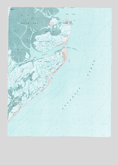
Ship Shoal Inlet, VA USGS Topographic Map
Click on map above to begin viewing in our Map Viewer.

This topographic map contains these locations and features:
Feature Name Type Latitude Longitude GNIS ID View Map
Big Creek MarshSwampN37.1799°W75.8549°1463342View Map
Black Rock ChannelGutN37.2238°W75.8455°1463503View Map
Bungalow InletGutN37.1551°W75.8591°1464096View Map
Evans CreekGutN37.2032°W75.8733°1495517View Map
Godwin IslandIslandN37.2176°W75.8302°1477913View Map
Godwin Island CreekGutN37.2138°W75.8269°1467184View Map
Little InletGutN37.1824°W75.8233°1469570View Map
Main Ship Shoal ChannelChannelN37.1954°W75.8594°1470019View Map
Mink CreekGutN37.1965°W75.8216°1470606View Map
Mink IslandIslandN37.1974°W75.8310°1470610View Map
Mink Island BayBayN37.1788°W75.8430°1470611View Map
Mud HoleLakeN37.1665°W75.8449°1471213View Map
Mud Hole CreekGutN37.1757°W75.8260°1471214View Map
Mud Hole InletGutN37.1668°W75.8477°1471215View Map
Myrtle IslandIslandN37.1932°W75.8166°1471300View Map
Myrtle Island BeachBeachN37.1915°W75.8099°1471301View Map
New InletBayN37.2432°W75.7994°1471456View Map
Pudding CreekGutN37.1624°W75.8716°1472846View Map
Red Drum DrainGutN37.2410°W75.8252°1473043View Map
Shell CreekGutN37.1768°W75.8369°1474469View Map
Ship Shoal InletGutN37.2115°W75.8035°1474533View Map
Ship Shoal IslandIslandN37.2196°W75.8021°1474534View Map
Smith IslandIslandN37.1440°W75.8696°1477933View Map
South BayBayN37.2471°W75.8460°1474833View Map
White Perch ChannelGutN37.2015°W75.8696°1476626View Map

Note: Coordinates in the location and feature list above are referenced to NAD83 datum.


Copyright (C) 2008-2024 Ryan Niemi / Sunset Dynamics ... All Rights Reserved