TopoQuest Logo
Do you find TopoQuest useful?
Help keep TopoQuest running and adding new maps/features by donating!
Bitcoin:  19c7KJd3qBynnjoSw5npx9KScwjBe4ifkT
Litecoin:  LXs6TkuXGGXo1vDsWCkWVdjQX94eUKd6ui
Home View Maps Find Maps Find Places Resources & Links


Shirley, Indiana Topographic Map

USGS Map Title: Shirley, IN
USGS Map MRC: 39085H5
DRG (GeoTIFF) Download: o39085h5.tif


Neighboring USGS Topographic Map Quads:


  Anderson South, IN  
40085A6
 

  Middletown, IN  
40085A5
 

  Sulphur Springs, IN  
40085A4
 

  Pendleton, IN  
39085H6
 

  Shirley, IN  
39085H5
 

  New Castle West, IN  
39085H4
 

  Cleveland, IN  
39085G6
 

  Knightstown, IN  
39085G5
 

  Dunreith, IN  
39085G4


Map MRC Location:

N40°
W86°
N40°
W85°
H8 H7 H6 H5 H4 H3 H2 H1
G8 G7 G6 G5 G4 G3 G2 G1
F8 F7 F6 F5 F4 F3 F2 F1
E8 E7 E6 E5 E4 E3 E2 E1
D8 D7 D6 D5 D4 D3 D2 D1
C8 C7 C6 C5 C4 C3 C2 C1
B8 B7 B6 B5 B4 B3 B2 B1
A8 A7 A6 A5 A4 A3 A2 A1
N39°
W86°
N39°
W85°

Shirley, IN USGS 1:24K Topographic Map Preview:
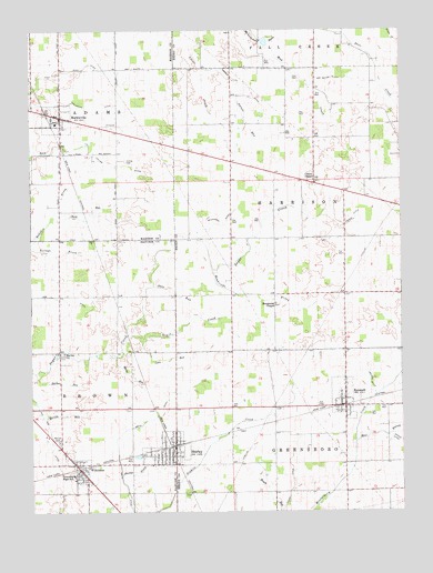
Shirley, IN USGS Topographic Map
Click on map above to begin viewing in our Map Viewer.

This topographic map contains these locations and features:
Feature Name Type Latitude Longitude GNIS ID View Map
Center ChapelChurchN39.9612°W85.5294°432314View Map
Chadwick DitchCanalN39.9809°W85.6036°432378View Map
Chick RunStreamN39.9534°W85.6155°432470View Map
Collier CemeteryCemeteryN39.9661°W85.5927°432785View Map
Collier DitchCanalN39.9650°W85.5961°432786View Map
Corn RunStreamN39.9195°W85.5872°432977View Map
Farmer DitchCanalN39.9850°W85.5533°434396View Map
Fort DitchCanalN39.9900°W85.6069°434685View Map
Grain CreekStreamN39.9209°W85.5922°435293View Map
Harlan ChurchChurchN39.9164°W85.6141°435738View Map
Harlan RunStreamN39.9112°W85.6239°435739View Map
Hendricks BrookStreamN39.9378°W85.5639°436017View Map
Hendricks ChapelChurchN39.9289°W85.5425°436018View Map
Judge DitchCanalN39.8806°W85.5380°437136View Map
KennardPopulated PlaceN39.9039°W85.5194°437241View Map
Kennard Volunteer Fire DepartmentBuildingN39.9043°W85.5187°2625969View Map
Maize RunStreamN39.9153°W85.5964°438488View Map
MarklevillePopulated PlaceN39.9778°W85.6147°438628View Map
McCray CemeteryCemeteryN39.8931°W85.6158°438829View Map
McCray RunStreamN39.9000°W85.6214°438830View Map
Mont BranchStreamN39.8928°W85.5161°439351View Map
Nelson DitchCanalN39.9092°W85.5111°439996View Map
Oats RunStreamN39.9339°W85.5839°440489View Map
Owner RunStreamN39.9864°W85.5544°440813View Map
Pee Dee DitchCanalN39.8964°W85.6191°440972View Map
Pierce DitchChurchN39.9495°W85.5211°441109View Map
ShirleyPopulated PlaceN39.8920°W85.5769°443421View Map
Shirley DrainStreamN39.8848°W85.5947°443423View Map
Shirley Police DepartmentBuildingN39.8928°W85.5768°2758426View Map
Shirley Volunteer Fire DepartmentBuildingN39.8904°W85.5764°2626035View Map
Smith DitchCanalN39.8939°W85.5969°443690View Map
Sugar Creek Air ParkAirportN39.9220°W85.5988°2677033View Map
Town of KennardCivilN39.9054°W85.5222°2397014View Map
Town of MarklevilleCivilN39.9764°W85.6168°2396737View Map
Town of ShirleyCivilN39.8910°W85.5801°2397659View Map
Town of WilkinsonCivilN39.8854°W85.6084°2397744View Map
Township of AdamsCivilN39.9966°W85.6246°453078View Map
Township of GreensboroCivilN39.8904°W85.5039°453353View Map
Township of HarrisonCivilN39.9536°W85.5099°453388View Map
Van Meter DitchCanalN39.9875°W85.5228°445213View Map
Weeks DitchCanalN39.8928°W85.5008°445636View Map
WilkinsonPopulated PlaceN39.8859°W85.6089°446041View Map
Wilkinson DitchCanalN39.9500°W85.5608°446042View Map
Wilkinson Fire DepartmentBuildingN39.8882°W85.6110°2701349View Map
Wilkinson Volunteer Fire DepartmentBuildingN39.8877°W85.6046°2625646View Map
WoodvillePopulated PlaceN39.9156°W85.5447°452162View Map

Note: Coordinates in the location and feature list above are referenced to NAD83 datum.


Copyright (C) 2008-2025 Ryan Niemi / Sunset Dynamics ... All Rights Reserved