TopoQuest Logo
Do you find TopoQuest useful?
Help keep TopoQuest running and adding new maps/features by donating!
Bitcoin:  19c7KJd3qBynnjoSw5npx9KScwjBe4ifkT
Litecoin:  LXs6TkuXGGXo1vDsWCkWVdjQX94eUKd6ui
Home View Maps Find Maps Find Places Resources & Links


Black Hills, Colorado Topographic Map

USGS Map Title: Black Hills, CO
USGS Map MRC: 37104F8
DRG (GeoTIFF) Download: o37104f8.tif


Neighboring USGS Topographic Map Quads:


  Badito Cone, CO  
37105G1
 

  Hayden Butte, CO  
37104G8
 

  Huerfano Butte, CO  
37104G7
 

  Farisita, CO  
37105F1
 

  Black Hills, CO  
37104F8
 

  Walsenburg North, CO  
37104F7
 

  La Veta, CO  
37105E1
 

  Ritter Arroyo, CO  
37104E8
 

  Walsenburg South, CO  
37104E7


Map MRC Location:

N38°
W105°
N38°
W104°
H8 H7 H6 H5 H4 H3 H2 H1
G8 G7 G6 G5 G4 G3 G2 G1
F8 F7 F6 F5 F4 F3 F2 F1
E8 E7 E6 E5 E4 E3 E2 E1
D8 D7 D6 D5 D4 D3 D2 D1
C8 C7 C6 C5 C4 C3 C2 C1
B8 B7 B6 B5 B4 B3 B2 B1
A8 A7 A6 A5 A4 A3 A2 A1
N37°
W105°
N37°
W104°

Black Hills, CO USGS 1:24K Topographic Map Preview:
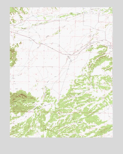
Black Hills, CO USGS Topographic Map
Click on map above to begin viewing in our Map Viewer.

This topographic map contains these locations and features:
Feature Name Type Latitude Longitude GNIS ID View Map
AlamoPopulated PlaceN37.6556°W104.9586°194234View Map
Alamo Mine Number 1MineN37.6578°W104.9630°194232View Map
Barbour MineMineN37.6658°W104.9561°1735125View Map
Bells GapGapN37.7103°W104.8767°194227View Map
Big Four MineMineN37.7000°W104.9280°1735133View Map
Black HillsSummitN37.6636°W104.9919°194230View Map
Butte Valley MineMineN37.6664°W104.9561°194233View Map
Calumet Number One MineMineN37.7133°W104.8814°1735127View Map
Dan Mahan DitchCanalN37.7442°W104.8975°194220View Map
DelcarbonPopulated PlaceN37.7125°W104.8769°194226View Map
Huerfano CountyCivilN37.6847°W104.9606°198143View Map
Jack Allen DitchCanalN37.7487°W104.8877°2722942View Map
Kebler MineMineN37.7011°W104.9283°194228View Map
Kebler Number Two MineMineN37.7011°W104.9283°1735128View Map
Larrimore MineMineN37.7158°W104.8994°1735129View Map
Major MineMineN37.7156°W104.9014°194223View Map
Major RanchLocaleN37.6592°W104.9703°194231View Map
Martin Ditch Number 2CanalN37.7325°W104.9892°169516View Map
Ojo de Alamo ArroyoStreamN37.7475°W104.8758°194221View Map
Pino DitchCanalN37.7378°W104.9419°194219View Map
Shamrock MineMineN37.7111°W104.9075°194222View Map
StrongPopulated PlaceN37.7125°W104.9022°194224View Map
Sunnyside MineMineN37.7195°W104.8936°1735130View Map
TiogaPopulated PlaceN37.6989°W104.9275°194229View Map
Turner MineMineN37.7136°W104.8828°194225View Map
Turner MineMineN37.7231°W104.8758°1735156View Map
Vigil and Saint VrainCivilN37.7445°W104.9172°203709View Map

Note: Coordinates in the location and feature list above are referenced to NAD83 datum.


Copyright (C) 2008-2025 Ryan Niemi / Sunset Dynamics ... All Rights Reserved