TopoQuest Logo
Do you find TopoQuest useful?
Help keep TopoQuest running and adding new maps/features by donating!
Bitcoin:  19c7KJd3qBynnjoSw5npx9KScwjBe4ifkT
Litecoin:  LXs6TkuXGGXo1vDsWCkWVdjQX94eUKd6ui
Home View Maps Find Maps Find Places Resources & Links


Sinton West, Texas Topographic Map

USGS Map Title: Sinton West, TX
USGS Map MRC: 28097A5
DRG (GeoTIFF) Download: o28097a5.tif


Neighboring USGS Topographic Map Quads:


  Bullshead Creek, TX  
28097B6
 

  Papalote, TX  
28097B5


  West Sinton, TX  
28097A6
 

  Sinton West, TX  
28097A5


  Edroy, TX  
27097H6
 

  Odem, TX  
27097H5
 

  Taft, TX  
27097H4


Map MRC Location:

N29°
W98°
N29°
W97°
H8 H7 H6 H5 H4 H3 H2 H1
G8 G7 G6 G5 G4 G3 G2 G1
F8 F7 F6 F5 F4 F3 F2 F1
E8 E7 E6 E5 E4 E3 E2 E1
D8 D7 D6 D5 D4 D3 D2 D1
C8 C7 C6 C5 C4 C3 C2 C1
B8 B7 B6 B5 B4 B3 B2 B1
A8 A7 A6 A5 A4 A3 A2 A1
N28°
W98°
N28°
W97°

Sinton West, TX USGS 1:24K Topographic Map Preview:
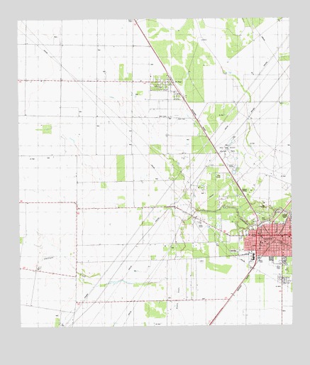
Sinton West, TX USGS Topographic Map
Click on map above to begin viewing in our Map Viewer.

This topographic map contains these locations and features:
Feature Name Type Latitude Longitude GNIS ID View Map
Alfred C 'Bubba' Thomas AirportAirportN28.0410°W97.5418°1387548View Map
Church of ChristChurchN28.0356°W97.5131°2023561View Map
City of SintonCivilN28.0404°W97.5145°2411906View Map
City of Sinton Emergency Medical ServiceBuildingN28.0381°W97.5077°2656091View Map
Colony Estates of Sinton ColoniaPopulated PlaceN28.0083°W97.5633°2011354View Map
Corriente Estates ColoniaPopulated PlaceN28.0222°W97.5503°2011355View Map
County of San Patricio - Juvenile Probation DepartmentSchoolN28.0276°W97.5118°2434533View Map
Dave Odem Elementary SchoolSchoolN28.0359°W97.5014°2008885View Map
Del Sol Census Designated PlaceCensusN28.0132°W97.5202°2586923View Map
Del Sol ColoniaPopulated PlaceN28.0122°W97.5172°2011359View Map
Del Sol-Loma Linda Census Designated Place (historical)CensusN28.0114°W97.5056°2408653View Map
Dodd ColoniaPopulated PlaceN28.0314°W97.5042°2011360View Map
Dodd Number 2 ColoniaPopulated PlaceN28.0303°W97.5033°2011361View Map
First Baptist ChurchChurchN28.0356°W97.5131°2023672View Map
Gonzales 12 ColoniaPopulated PlaceN28.0192°W97.5033°2011315View Map
Grace Lutheran ChurchChurchN28.0331°W97.5108°2023568View Map
J G Gonzales ColoniaPopulated PlaceN28.0192°W97.5064°2011319View Map
La Paloma Addition Census Designated PlaceCensusN28.0170°W97.5009°2586950View Map
La Paloma Addition ColoniaPopulated PlaceN28.0183°W97.5033°2011322View Map
Lamar Elementary SchoolSchoolN28.0294°W97.5176°2008878View Map
Loma Linda ColoniaPopulated PlaceN28.0053°W97.5014°2011327View Map
M Merle Smith Junior High SchoolSchoolN28.0280°W97.5180°2008890View Map
Morgan Farm Census Designated PlaceCensusN28.0055°W97.5535°1852738View Map
Morgan Farm ColoniaPopulated PlaceN28.0192°W97.5483°2011329View Map
O'Farrell Acres Number 2 ColoniaPopulated PlaceN28.0253°W97.5633°2011289View Map
Peters SwaleStreamN28.0200°W97.5525°1343903View Map
Rob and Bessie Welder ParkParkN28.0695°W97.5275°1345295View Map
Saint PaulPopulated PlaceN28.0989°W97.5564°2034695View Map
Saint PaulPopulated PlaceN28.0995°W97.5558°1346060View Map
Saint Paul Census Designated PlaceCensusN28.0910°W97.5632°2409231View Map
Saint Paul Estates ColoniaPopulated PlaceN28.0803°W97.5672°2011294View Map
Saint Paul Number 1 ColoniaPopulated PlaceN28.0803°W97.5722°2011295View Map
San Patricio CountyCivilN28.0088°W97.5183°1383990View Map
San Patricio County Constable's Office Precinct 1BuildingN28.0276°W97.5118°2739441View Map
San Patricio County JailBuildingN28.0394°W97.5100°2738781View Map
San Patricio County Sheriff's OfficeBuildingN28.0396°W97.5099°2335112View Map
SintonPopulated PlaceN28.0367°W97.5092°1347172View Map
Sinton Alternative SchoolSchoolN28.0345°W97.5144°2008888View Map
Sinton City HallBuildingN28.0380°W97.5077°2753476View Map
Sinton Police DepartmentBuildingN28.0381°W97.5085°2335036View Map
Sinton Post OfficePost OfficeN28.0363°W97.5170°2731977View Map
Sinton Presbyterian ChurchChurchN28.0345°W97.5119°2023509View Map
Sinton SidingLocaleN28.0553°W97.5233°1347174View Map
Sinton Volunteer Fire DepartmentBuildingN28.0381°W97.5073°2334258View Map
Sinton-Odem DivisionCivilN28.0208°W97.5778°1939198View Map
Sun Country Estates ColoniaPopulated PlaceN28.0164°W97.6183°2011299View Map
Sunkist Country Estates ColoniaPopulated PlaceN28.0083°W97.5503°2011300View Map
W J Ranch ColoniaPopulated PlaceN28.0014°W97.5553°2011252View Map
Welder Elementary SchoolSchoolN28.0420°W97.5002°2008895View Map
Welder ParkParkN28.0483°W97.5111°1349628View Map

Note: Coordinates in the location and feature list above are referenced to NAD83 datum.


Copyright (C) 2008-2025 Ryan Niemi / Sunset Dynamics ... All Rights Reserved