TopoQuest Logo
Do you find TopoQuest useful?
Help keep TopoQuest running and adding new maps/features by donating!
Bitcoin:  19c7KJd3qBynnjoSw5npx9KScwjBe4ifkT
Litecoin:  LXs6TkuXGGXo1vDsWCkWVdjQX94eUKd6ui
Home View Maps Find Maps Find Places Resources & Links


Sioux Rapids, Iowa Topographic Map

USGS Map Title: Sioux Rapids, IA
USGS Map MRC: 42095H2
DRG (GeoTIFF) Download: o42095h2.tif


Neighboring USGS Topographic Map Quads:


  Royal, IA  
43095A3
 

  Greenville, IA  
43095A2
 

  Gillett Grove, IA  
43095A1
 

  Peterson, IA  
42095H3
 

  Sioux Rapids, IA  
42095H2
 

  Webb, IA  
42095H1
 

  Peterson SE, IA  
42095G3
 

  Rembrandt, IA  
42095G2
 

  Sioux Rapids SE, IA  
42095G1


Map MRC Location:

N43°
W96°
N43°
W95°
H8 H7 H6 H5 H4 H3 H2 H1
G8 G7 G6 G5 G4 G3 G2 G1
F8 F7 F6 F5 F4 F3 F2 F1
E8 E7 E6 E5 E4 E3 E2 E1
D8 D7 D6 D5 D4 D3 D2 D1
C8 C7 C6 C5 C4 C3 C2 C1
B8 B7 B6 B5 B4 B3 B2 B1
A8 A7 A6 A5 A4 A3 A2 A1
N42°
W96°
N42°
W95°

Sioux Rapids, IA USGS 1:24K Topographic Map Preview:
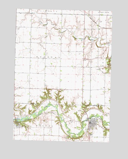
Sioux Rapids, IA USGS Topographic Map
Click on map above to begin viewing in our Map Viewer.

This topographic map contains these locations and features:
Feature Name Type Latitude Longitude GNIS ID View Map
Barnes Township CemeteryCemeteryN42.8880°W95.2400°463386View Map
Bluebird AccessLocaleN42.8953°W95.2308°1925846View Map
Bluebird CreekStreamN42.8964°W95.2386°464418View Map
Buena Vista County Ambulance Sioux RapidsBuildingN42.8928°W95.1502°2599948View Map
City of Linn GroveCivilN42.8928°W95.2423°2395722View Map
City of Sioux RapidsCivilN42.8916°W95.1488°468721View Map
CornellPopulated PlaceN42.9444°W95.1400°455632View Map
Cornell (historical)LocaleN42.9444°W95.1400°1944230View Map
Cornell Post Office (historical)Post OfficeN42.9444°W95.1400°1944231View Map
Douglas Centre Post Office (historical)Post OfficeN42.9458°W95.1619°466451View Map
Douglas TownhallBuildingN42.9539°W95.2108°463355View Map
Douglas Township CemeteryCemeteryN42.9255°W95.2453°463354View Map
Faith Lutheran ChurchChurchN42.8925°W95.1464°1925805View Map
Fanny Fern CemeteryCemeteryN42.9530°W95.1611°456537View Map
First Co-op ElevatorLocaleN42.8933°W95.1511°1925798View Map
First Lutheran ChurchChurchN42.8878°W95.1517°1925807View Map
First United ChurchChurchN42.8925°W95.1475°1925804View Map
Fox and Boyd Dental CenterHospitalN42.8933°W95.1503°1925802View Map
Gabrielson ParkParkN42.8800°W95.1497°1925811View Map
Gilbert James Wildlife AreaParkN42.9250°W95.1942°1944242View Map
Gustafson LakeLakeN42.8800°W95.1497°1925812View Map
KTFG-FM (Sioux Rapids)TowerN42.9094°W95.1600°467346View Map
Liberty CemeteryCemeteryN42.9897°W95.1419°458319View Map
Linn GrovePopulated PlaceN42.8916°W95.2467°458415View Map
Linn Grove Dam ParkParkN42.8930°W95.2467°1925847View Map
Linn Grove Post OfficePost OfficeN42.8916°W95.2467°1925844View Map
Linn Grove Public LibraryBuildingN42.8916°W95.2467°1925843View Map
Linngrove (historical)LocaleN42.8925°W95.2447°1925845View Map
Little Sioux Country ClubLocaleN42.9044°W95.1619°465865View Map
Lone Tree CemeteryCemeteryN42.8819°W95.1494°458580View Map
Presbyterian ChurchChurchN42.8916°W95.2467°1925842View Map
Saint Joseph's Catholic ChurchChurchN42.8925°W95.1436°1925806View Map
Saint Josephs CemeteryCemeteryN42.8883°W95.1328°461130View Map
Sioux Care CenterHospitalN42.8947°W95.1439°1925803View Map
Sioux RapidsPopulated PlaceN42.8933°W95.1511°461655View Map
Sioux Rapids (historical)LocaleN42.8961°W95.1469°1925809View Map
Sioux Rapids Area Historical Association MuseumBuildingN42.8933°W95.1511°1925801View Map
Sioux Rapids Baptist ChurchChurchN42.8919°W95.1480°1925808View Map
Sioux Rapids City HallBuildingN42.8933°W95.1511°1925800View Map
Sioux Rapids City ParkParkN42.8961°W95.1503°1925810View Map
Sioux Rapids Fire DepartmentBuildingN42.8967°W95.1435°1925797View Map
Sioux Rapids Memorial LibraryBuildingN42.8933°W95.1511°1925799View Map
Sioux Rapids Post OfficePost OfficeN42.8933°W95.1511°1925796View Map
Soldier CreekStreamN42.8825°W95.1772°461742View Map
Township of DouglasCivilN42.9529°W95.2106°467727View Map
Trinity Lutheran ChurchChurchN42.8916°W95.2467°1925841View Map
Zion CemeteryCemeteryN42.9807°W95.2498°463264View Map

Note: Coordinates in the location and feature list above are referenced to NAD83 datum.


Copyright (C) 2008-2025 Ryan Niemi / Sunset Dynamics ... All Rights Reserved